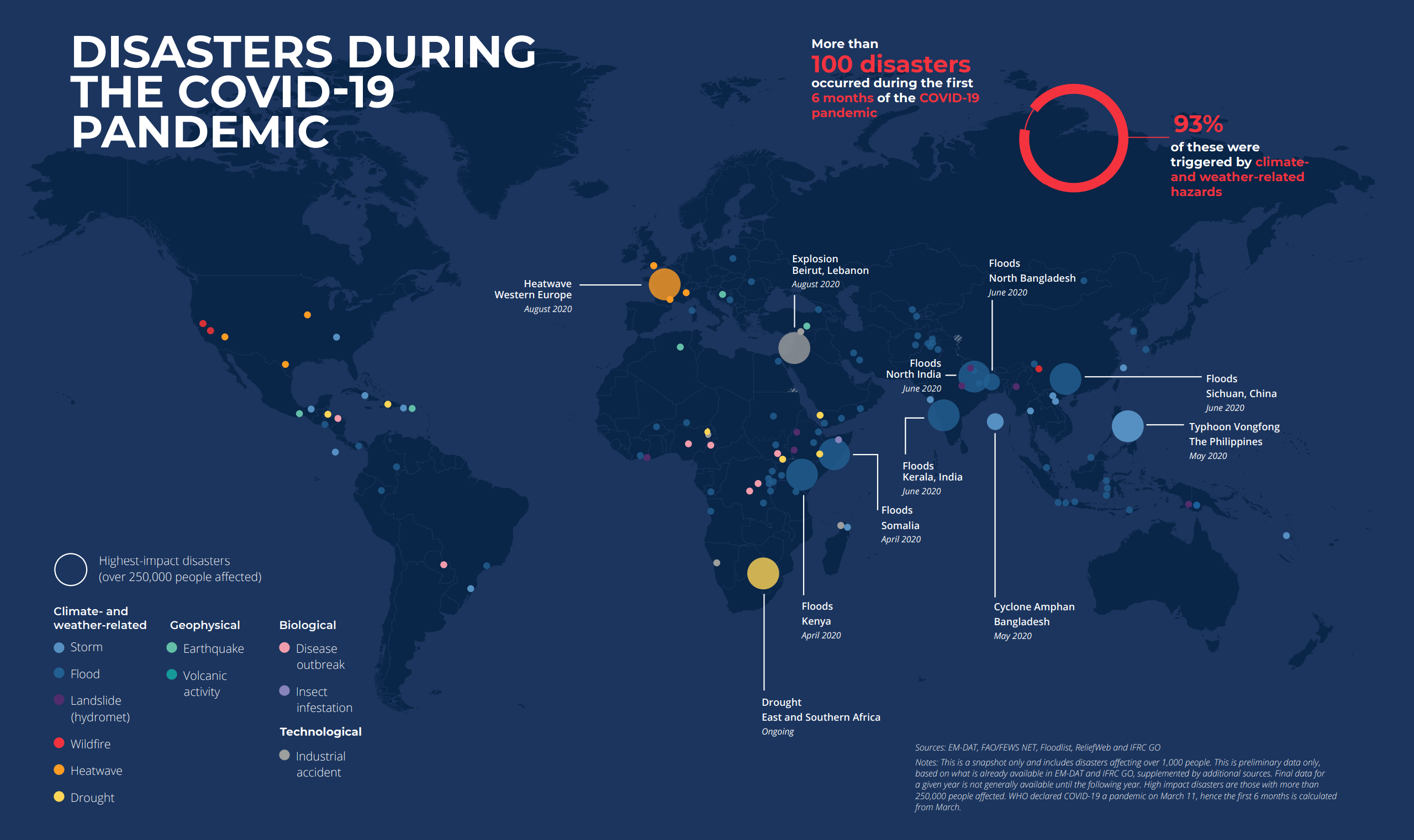
GOES-17 satellite view of the largest known stratospheric smoke injection, from Australia wildfires, 2 January 2020. This photo shows the first phase (29-31 December 2019) of the Australian New Year Super Outbreak (Anyso), which had unprecedented fire and pyrocumulonimbus cloud (pyroCb) activity. this event was the first known pyroCb “super outbreak”, with 32 updrafts over ~45hrs (day and night). Previous events recorded less than 10 updrafts in less than 24 hours. Photo: CIRA

Towering pyrocumulonimbus clouds can spew as much aerosol as volcanic eruptions – The Australian 2019-2020 outbreak exceeded previously unprecedented events “on almost every level”

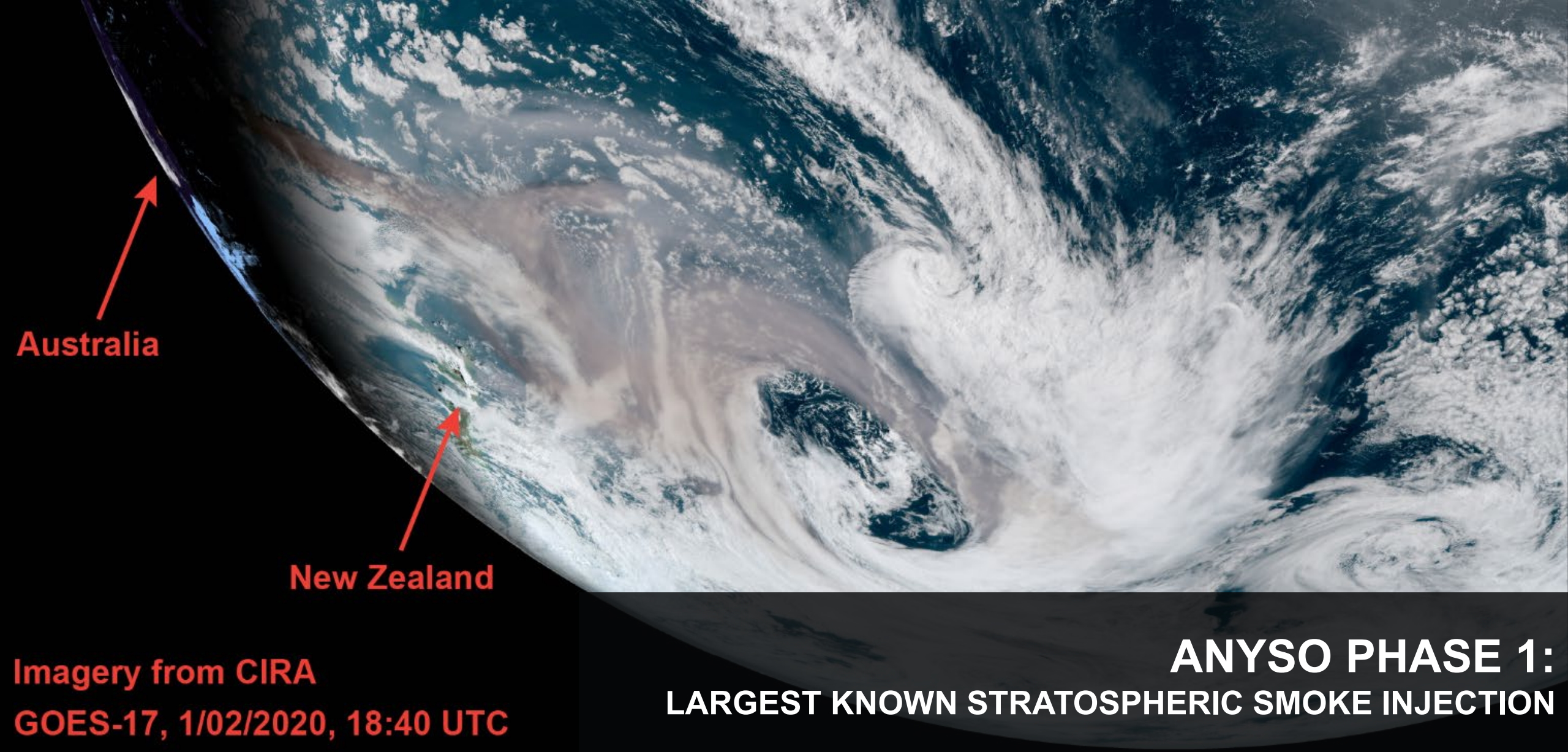
By Carolyn Gramling 15 December 2020 (Science News) – A massive tower of smoke generated by Australian wildfires in late 2019 set a new record for the loftiest and largest fire-spawned thunderstorms ever measured. It also may represent a new class of volcanic-scale “pyrocumulonimbus” events, scientists said in an online news conference 11 December 2020 at […]

Map showing the age of sea ice in the Arctic at winter maximum in 2000 (left, week of March 18) and 2020 (right, week of March 21). Ice older than 5 years (white) is very rare today; only a small ribbon remains along the islands of the Canadian Arctic. Age is a stand-in for ice thickness and durability; young ice is thinner and more likely to melt in the summer. NOAA Climate.gov map, based on data from the National Snow and Ice Data Center. Graphic: NOAA

Sea ice loss and extreme wildfires mark another year of Arctic change – “The transformation of the Arctic to a warmer, less frozen, and biologically changed region is well underway”

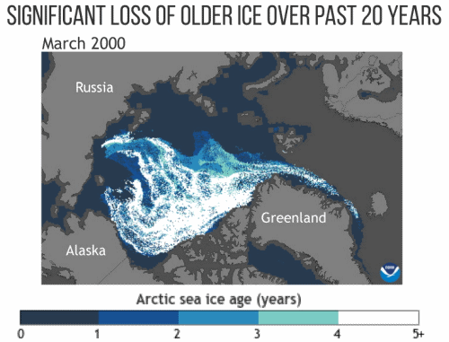
8 December 2020 (NOAA) – NOAA’s 15th Arctic Report Card catalogs for 2020 the numerous ways that climate change continues to disrupt the polar region, with second-highest air temperatures and second-lowest summer sea ice driving a cascade of impacts, including the loss of snow and extraordinary wildfires in northern Russia. The Arctic Report Card is […]

The global COVID-19 lockdowns caused fossil carbon dioxide emissions to decline by an estimated 2.4 billion tonnes in 2020 - a record drop according to researchers at the University of East Anglia, University of Exeter and the Global Carbon Project. It means that in 2020 fossil CO2 emissions are predicted to be approximately 34 GtCO2, seven per cent lower than in 2019. Emissions from transport account for the largest share of the global decrease. Those from surface transport, such as car journeys, fell by approximately half at the peak of the COVID lockdowns. Total CO2 emissions from human activities - from fossil CO2 and land-use change - are set to be around 39 GtCO2 in 2020. Video: UEA

COVID lockdown causes record drop in carbon dioxide emissions for 2020

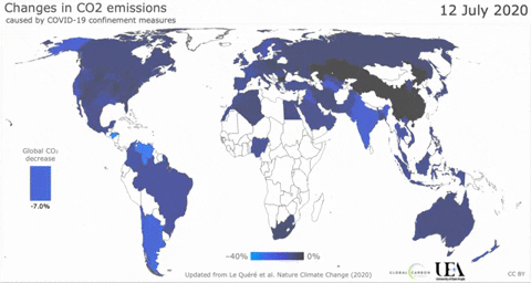
11 December 2020 (UEA) – The global COVID-19 lockdowns caused fossil carbon dioxide emissions to decline by an estimated 2.4 billion tonnes in 2020 – a record drop according to researchers at the University of East Anglia (UEA), University of Exeter, and the Global Carbon Project. The fall is considerably larger than previous significant decreases […]

Overall state of all natural World Heritage sites in 2014, 2017, and 2020. Graphic: IUCN

Climate change now top threat to natural World Heritage sites – Great Barrier Reef declines to “critical” status

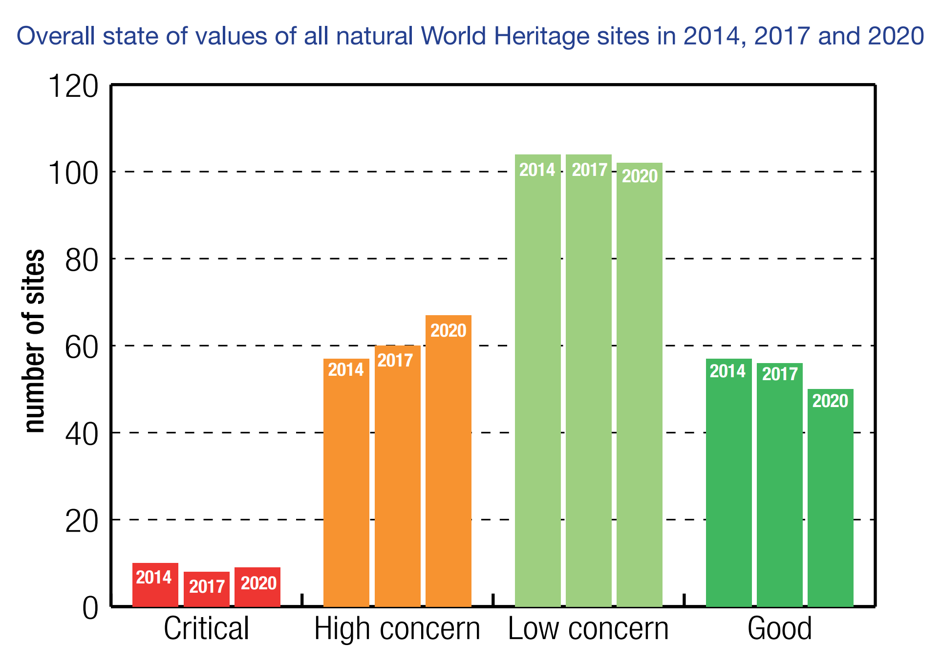
GLAND, SWITZERLAND, 2 December 2020 (IUCN) – Climate change is now the biggest threat to natural World Heritage, according to a report [pdf] published today by IUCN (International Union for Conservation of Nature). A third (33%) of natural World Heritage sites are threatened by climate change, including the world’s largest coral reef, the Great Barrier […]

Global map of temperature anomalies relative to the 1981-2010 long-term average from the ERA5 reanalysis for January to October 2020. Graphic: Copernicus Climate Change Service / ECMWF

WMO: 2020 on track to be one of three warmest years on record – More than 80 percent of the global ocean experienced a marine heatwave in 2020

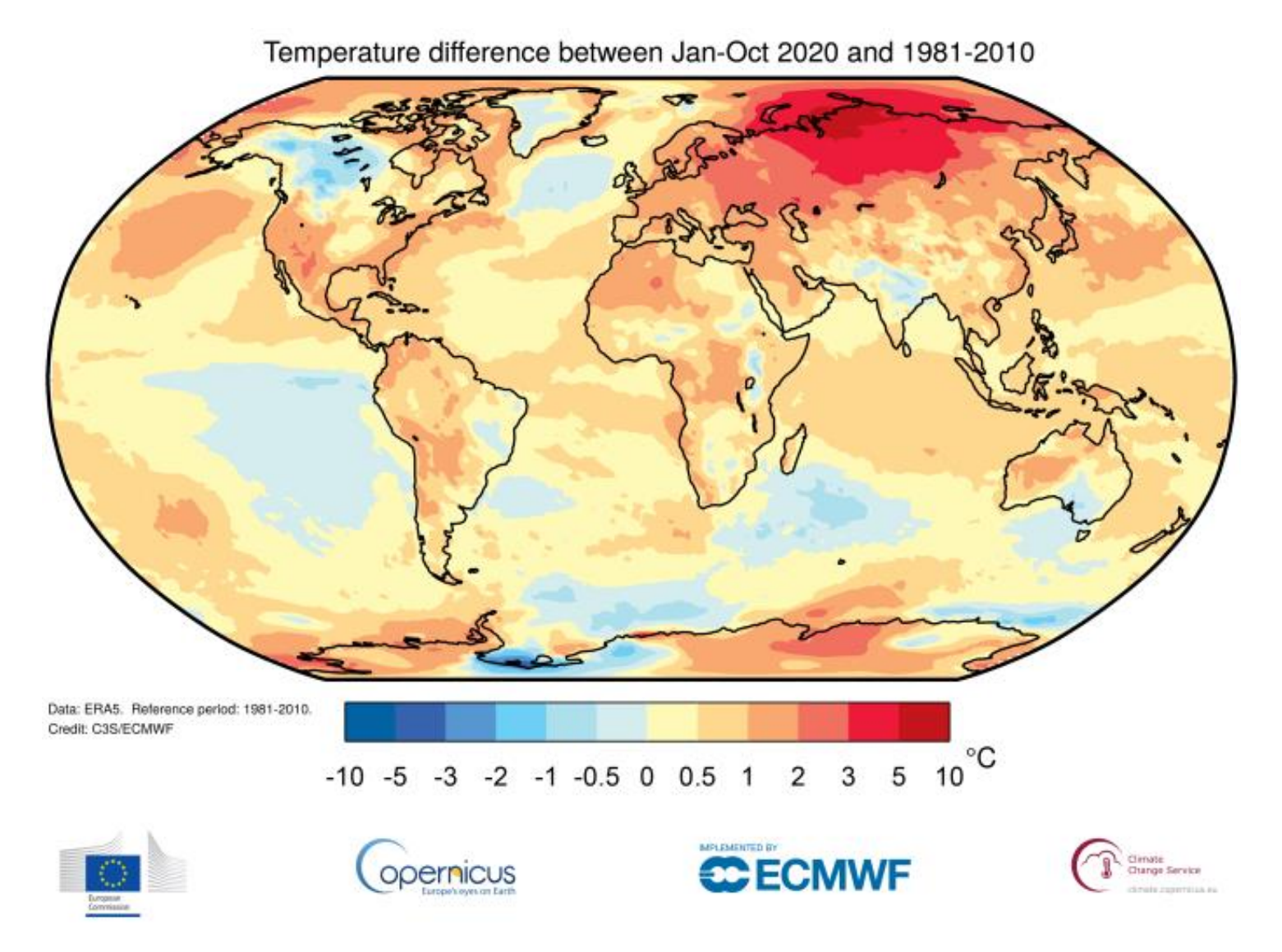
GENEVA, 2 December 2020 (WMO) – Climate change continued its relentless march in 2020, which is on track to be one of the three warmest years on record. 2011-2020 will be the warmest decade on record, with the warmest six years all being since 2015, according to the World Meteorological Organization. Ocean heat is at […]

August 2020 blended land and sea surface temperature percentiles. Graphic: NOAA / NCEI

August 2020 was the world’s second-warmest August on record – The year 2020 has more than a 99.9 percent chance to rank among the five warmest years on record

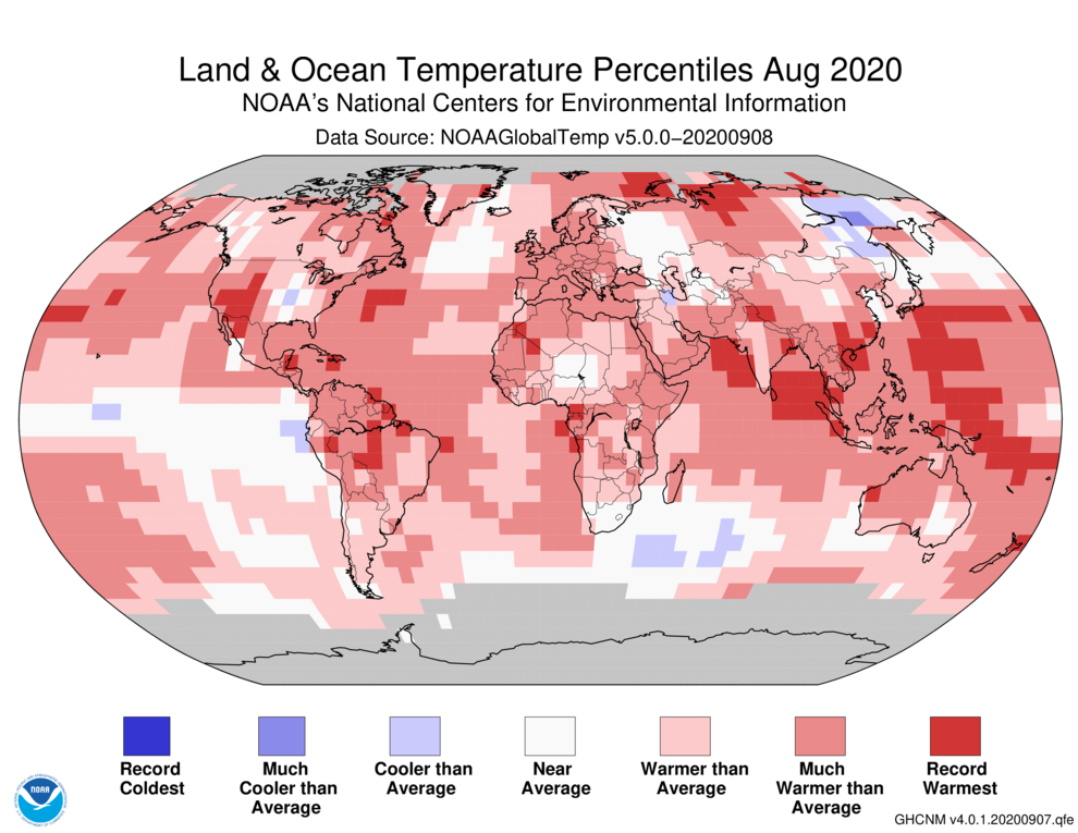
By Jeff Masters, Ph.D. 15 September 2020 (Yale Climate Connections) – August 2020 was the second-warmest August since global record keeping began in 1880, NOAA’s National Centers for Environmental Information, or NCEI, reported September 14. The month was just 0.04 degrees Celsius behind the record set in August 2016. NASA rated the month as the third-warmest August on […]

The Ozone Mapping and Profiler Suite (OMPS) and the Visible Infrared Imaging Radiometer Suite (VIIRS) on the NOAA-NASA Suomi NPP satellite captured this extremely think blanket of smoke along the West Coast on 9 September 2020. OMPS measured smoke clouds over the western U.S. with higher aerosol index values than anything Colin Seftor, an atmospheric scientist at NASA’s Goddard Space Flight Center, says he has ever seen with the instrument. Graphic: Joshua Stevens / NASA Earth Observatory

California’s wildfire smoke plumes are unlike anything previously seen – California fire carbon emissions in 2020 exceed previous record by nearly 2 times

By Matthew Cappucci 12 September 2020 (The Washington Post) – More than 3.1 million acres have burned in California this year, part of a record fire season that still has four months to go. A suffocating cloud of smoke has veiled the West Coast for days, extending more than a thousand miles above the Pacific. And the […]

Satellite view of the Northridge Terrace neighborhood in Phoenix, Oregon before and after wildfire, 10 September 2020. Photo: Maxar Technologies

Satellite images show Phoenix and Talent, Oregon, have been “substantially destroyed” by wildfire – “This could be the greatest loss of human lives and property due to wildfire in our state’s history”

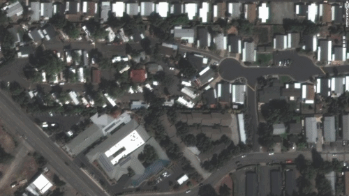
By Paul P. Murphy 10 September 2020 (CNN) – Swaths of the small southern Oregon cities of Phoenix and Talent now lie in ash, satellite images show, as wildfires wage unprecedented destruction across the US West. A massive burn scar cuts through parts of Talent and Phoenix, home to about 11,000 people combined. The wounded terrain, seen […]

Air temperatures across the United States on 6 September 2020, when much of the Southwest roasted in a dramatic heatwave. The map was derived from the Goddard Earth Observing System (GEOS) model and represents temperatures at 2 meters (about 6.5 feet) above the ground. The darkest red areas are where the model shows temperatures surpassing 113°F (45°C). Graphic: Joshua Stevens / NASA Earth Observatory

California heatwaves are becoming more frequent and lasting longer – “This has serious consequences for the fire season in Southern California”

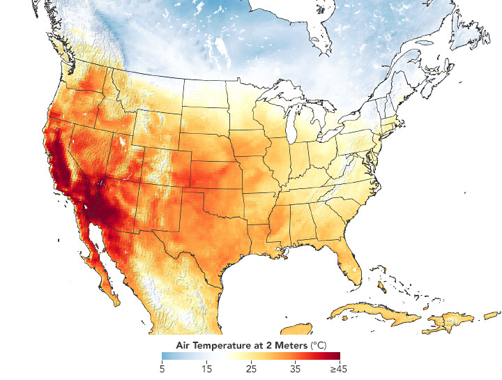
By Kasha Patel 11 September 2020 (NASA) – In early September 2020, an intense heatwave broke temperature records in several locations in Southern California. The dry, hot conditions helped fuel new and existing fires, which have consumed tens of thousands of acres of land. According to recently published research, these extremes fit a long-term trend toward longer and more […]

On 9 September 2020, the Moderate Resolution Imaging Spectroradiometer (MODIS) on NASA’s Terra satellite captured this natural-color image of thick smoke streaming from a line of intense fires in Oregon and California. Many communities in the region are facing extremely poor and sometimes hazardous air quality. Data: NASA EOSDIS/LANCE and GIBS/Worldview. Photo: Lauren Dauphin / NASA

Autumn could deliver the worst of California’s 2020 fire season – A scorching Labor Day weekend brought an all-time record heat and unprecedented fire spread, but fire risks climb in the fall

By Bob Henson 8 September 2020 (Yale Climate Connections) – Temperatures reached ghastly levels in southern California and wildfire carved a path close to two of the state’s iconic national parks as a historic heat dome gripped the western United States during the traditional end-of-summer Labor Day weekend. The heat had eased somewhat by Tuesday, […]

Social media & sharing icons powered by UltimatelySocial