Views of the Manhattan skyline at 10:02 a.m., 11:56 a.m., 12:53 p.m., and 1:53 p.m. as smoke from Canada wildfires engulfed the Northeast U.S. on 7 June 2023. Photo: EarthCam

New York City air quality hits worst level on record as smoke from Canada wildfires engulfs the Northeast U.S. – “I can taste the air”

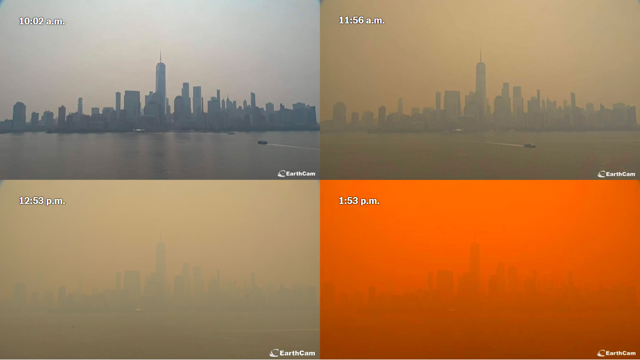
By Mike Ives and Liam Stack 7 June 2023 (The New York Times) – The sky in New York City rapidly darkened on Wednesday afternoon, as a plume of smoke from Canadian wildfires approached the nation’s largest city and sent the air quality index soaring past 324, the worst since the Environmental Protection Agency began […]

New Year’s Eve 2019: People seek shelter under heavy smoke at the Mallacoota Gymnasium relief centre during the Black Summer bushfires. Photo: Rachel Mounsey / The Sydney Morning Herald

Bushfires could kill almost 2500 Australians by 2030 – “This is not the first report saying this sort of thing, but each of the previous ones have to some extent been ignored by government”

By Lachlan Abbott 2 January 2023 (The Sydney Morning Herald) – Increasingly frequent and severe bushfires linked to climate change could kill nearly 2500 Australians and cost the economy billions of dollars by the end of the decade, according to new research. Modelling from Monash University’s Centre for Medicine Use and Safety has estimated 2418 […]

Geographical distribution of the measured mass light absorption coefficient (at 365 nm, babs-365, Mm−1, M = 10−6) of water-soluble brown carbon (BrC) in the circum-Arctic. The data dots are plotted at the middle of each sample. The shading was interpolated based on the measurements using the Data-Interpolating Variational Analysis method in the software Ocean Data View. The color range is set as the 10th and 90th percentiles of babs-365. The observed babs-365 of water-soluble BrC at Utqiaġvik (formerly Barrow) from August to September (2012) for PM10 samples (diamond) and at Alert from May to early June (1991) for total suspended samples (square) is also shown for comparison. Graphic: Yue, et al., 2022 / One Earth

Brown carbon from biomass burning imposes strong Arctic warming feedback – “We expect an increasing importance of brown carbon in the warming of the circum-arctic in the future”

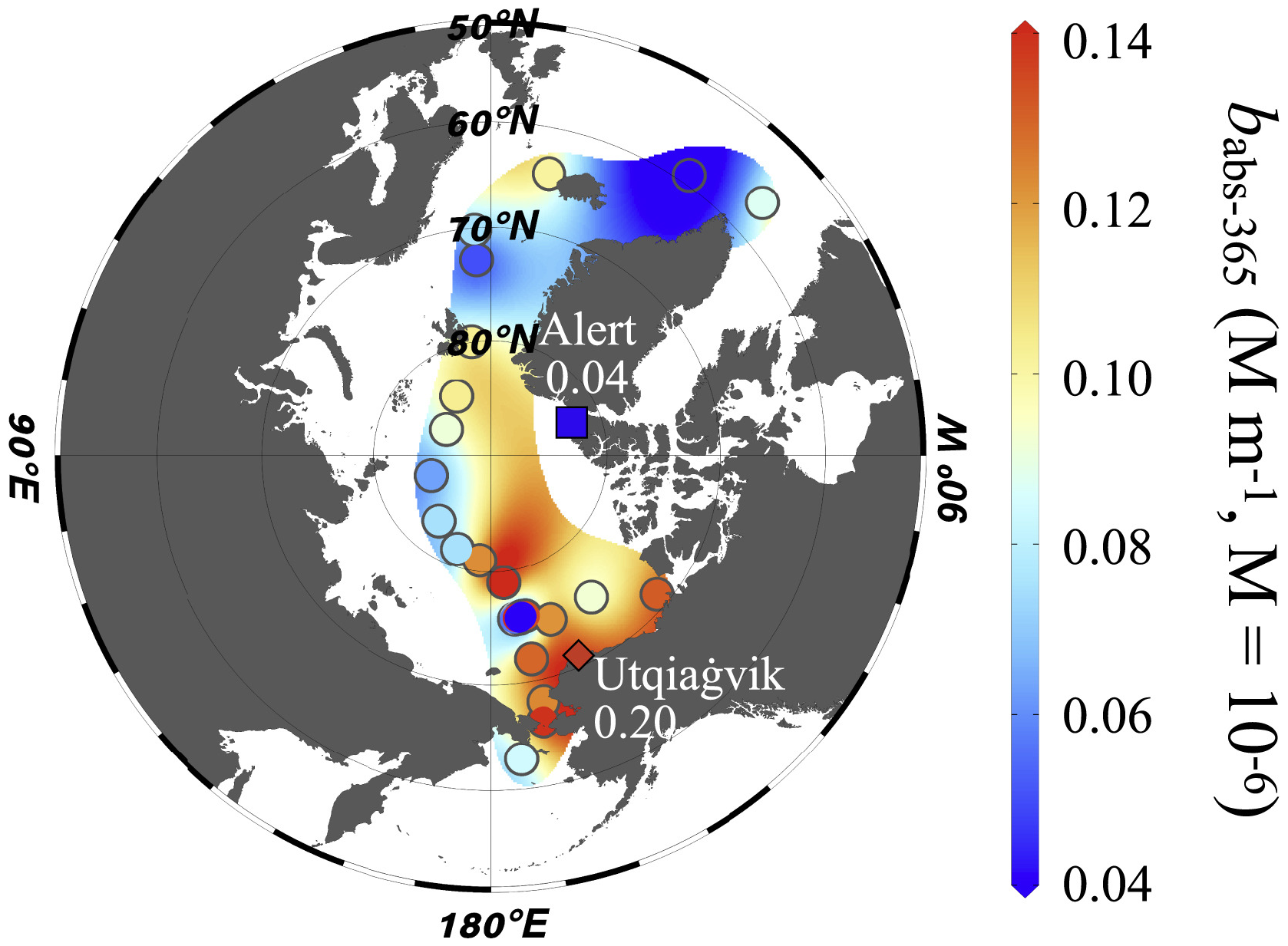
18 March 2022 (Max Planck Institute for Chemistry) – Rapid warming in the Arctic and accelerated glacier and sea ice melting have a huge impact on the global environment. Greenhouse gases, such as carbon dioxide, and black carbon aerosols are well-known warming agents. In contrast, atmospheric, light absorbing brown carbon particles belong to the least […]

Firefighters work at the scene of forest fire near Andreyevsky village outside Tyumen, western Siberia, Russia, on 16 June 2021. Wildfires in Siberia are releasing record amounts of greenhouse gases, scientists say, contributing to global warming. Photo: Maksim Slutsky / AP Photo

Siberia hit by unprecedented wildfires – 1.5 million hectares burn after driest weather in 150 years – “Everything is on fire”

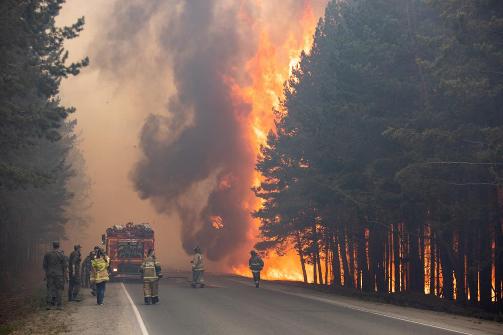
By Andrew Roth 20 July 2021 MOSCOW (The Guardian) – Every morning and evening for the last few days, shifts of young villagers have headed out into the taiga forest around Teryut with a seemingly impossible task: to quell the raging fires that have burned closer and closer for a month, shrouding this remote eastern […]

Black carbon mass density over North America from GEOS-5, 21 July 2021. Smoke from wildfires in the U.S. West poured into the eastern U.S. on 20-21 July 2021. In New York City, levels of fine particulate pollution rose above 170 on the air quality index, a level considered harmful even for healthy people. Data: GEOS-5 data from the Global Modeling and Assimilation Office at NASA GSFC. Graphic: Joshua Stevens / NASA Earth Observatory

Skies turn hazy from Pittsburgh to Washington to Boston, as smoke from fires in Canada pour into the U.S. Northeast

By Adam Voiland 23 July 2021 (NASA) – While plumes of wildfire smoke from western North America have passed over the northeastern U.S. and Canada multiple times each summer in recent years, they often go unnoticed. That is because smoke that spreads far from its source typically moves at a fairly high altitude—between 5 and 10 kilometers—as […]

GOES-17 satellite view of the largest known stratospheric smoke injection, from Australia wildfires, 2 January 2020. This photo shows the first phase (29-31 December 2019) of the Australian New Year Super Outbreak (Anyso), which had unprecedented fire and pyrocumulonimbus cloud (pyroCb) activity. this event was the first known pyroCb “super outbreak”, with 32 updrafts over ~45hrs (day and night). Previous events recorded less than 10 updrafts in less than 24 hours. Photo: CIRA

Towering pyrocumulonimbus clouds can spew as much aerosol as volcanic eruptions – The Australian 2019-2020 outbreak exceeded previously unprecedented events “on almost every level”

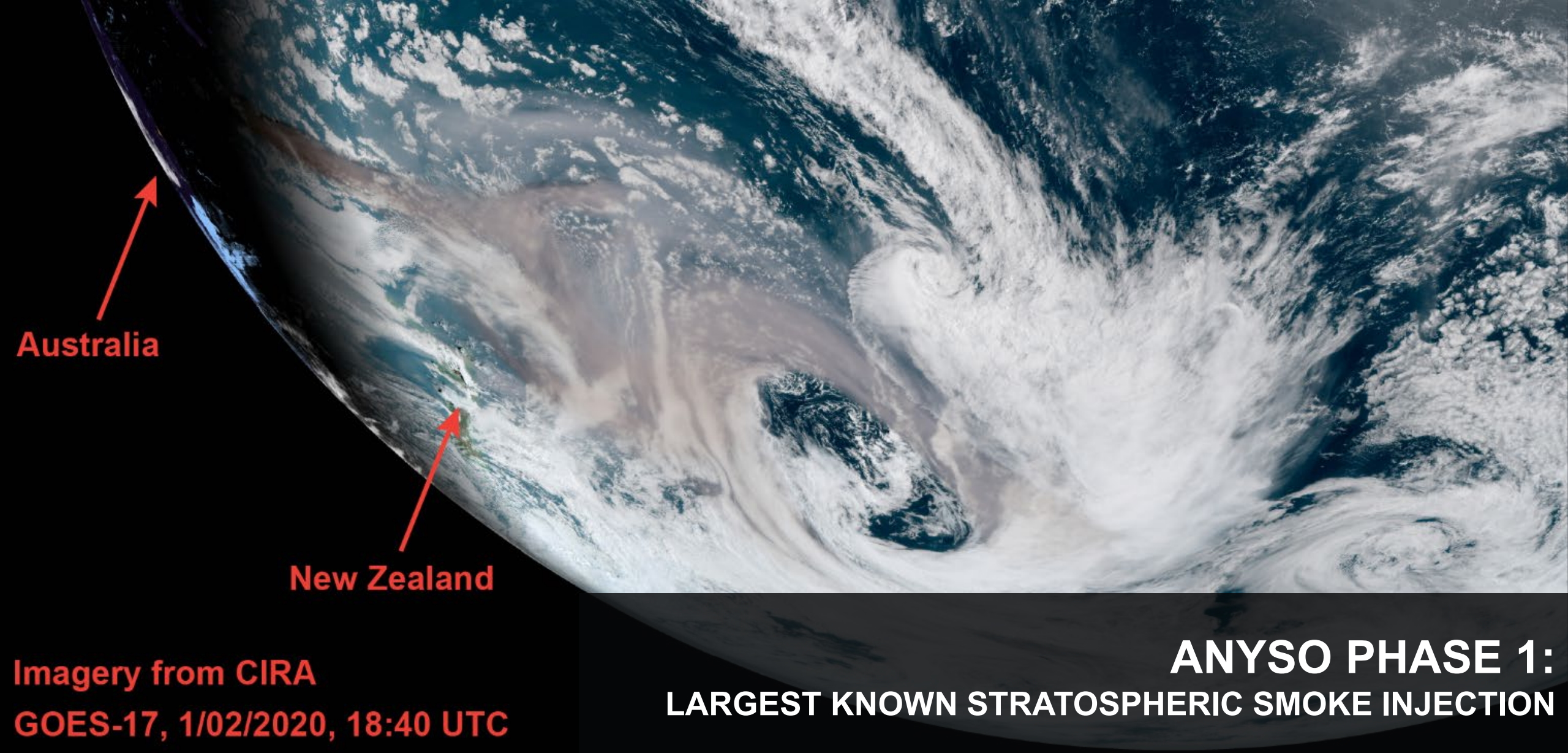
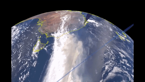
By Carolyn Gramling 15 December 2020 (Science News) – A massive tower of smoke generated by Australian wildfires in late 2019 set a new record for the loftiest and largest fire-spawned thunderstorms ever measured. It also may represent a new class of volcanic-scale “pyrocumulonimbus” events, scientists said in an online news conference 11 December 2020 at […]

The Ozone Mapping and Profiler Suite (OMPS) and the Visible Infrared Imaging Radiometer Suite (VIIRS) on the NOAA-NASA Suomi NPP satellite captured this extremely think blanket of smoke along the West Coast on 9 September 2020. OMPS measured smoke clouds over the western U.S. with higher aerosol index values than anything Colin Seftor, an atmospheric scientist at NASA’s Goddard Space Flight Center, says he has ever seen with the instrument. Graphic: Joshua Stevens / NASA Earth Observatory

California’s wildfire smoke plumes are unlike anything previously seen – California fire carbon emissions in 2020 exceed previous record by nearly 2 times

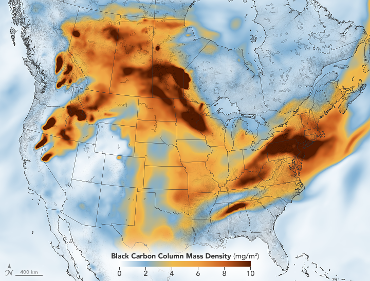
By Matthew Cappucci 12 September 2020 (The Washington Post) – More than 3.1 million acres have burned in California this year, part of a record fire season that still has four months to go. A suffocating cloud of smoke has veiled the West Coast for days, extending more than a thousand miles above the Pacific. And the […]

Breakdown of total fossil fuel support in PIDG, 2002-2018, by sub-sector ($USD). Data: Source: Private Infrastructure Development Group Annual Report 2018. Graphic: Global Witness

Obscure investment fund uses UK aid money to finance fossil fuel projects – “A farcical situation where the Government, on one hand, spends aid money to mitigate climate change, and on the other hand finances fossil fuels all over the world”

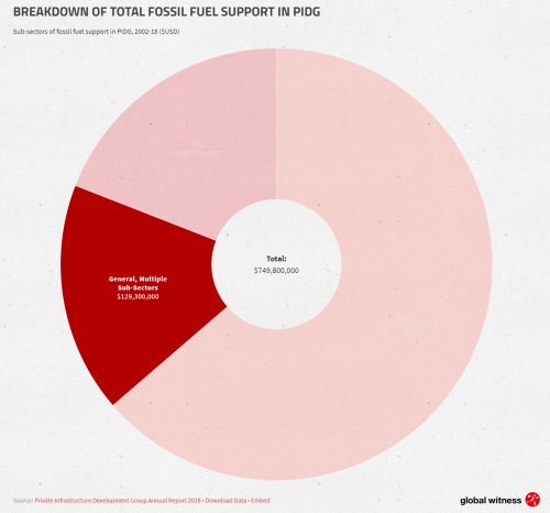
6 February 2020 (Global Witness) – We are at the beginning of a year of climate spin by the British Government. This year, the UK will host the 26th UN Climate Change Conference (COP26) in Glasgow. While the Government claims to be a ‘climate leader’, we reveal how a little-known investment group funded by the […]

Satellite photography and UV aerosol index showing smoke from the Australia bushfires being transported across the Atlantic Ocean from 27 December 2019 to 8 Kanuary 2020. Graphic: Colin Seftor / NASA

Australia fire smoke will complete a full circuit of Earth, NASA says

14 January 2020 (BBC News) – Smoke from the massive bushfires in Australia will soon circle the Earth back to the nation, says NASA. Massive infernos have raged along the nation’s east coast for months, pushing smoke across the Pacific. NASA said plumes from blazes around New Year’s Day had crossed South America, turning skies […]

As many fires are still burning in Australia, a regular GLOBE Observer (Glenn Evans in Coogee, New South Wales, about 10 km/6 miles southeast of Sydney), has been taking consistent clouds observations from the same location over the last few weeks, sometimes multiple observations on the same day. In this short video, you can see a compilation of their ground observations in December 2019, facing west and south alongside satellite imagery from the same day taken by the MODIS instrument on the Aqua satellite. Notice the sky coloration when heavy smoke plumes are visible in the satellite image, as well as the days when there is both haze and other types of clouds in the sky. Video: NASA GLOBE Observer

A megafire measuring 1.5 million acres forms in Australia as bushfires merge – “It is too late to leave”

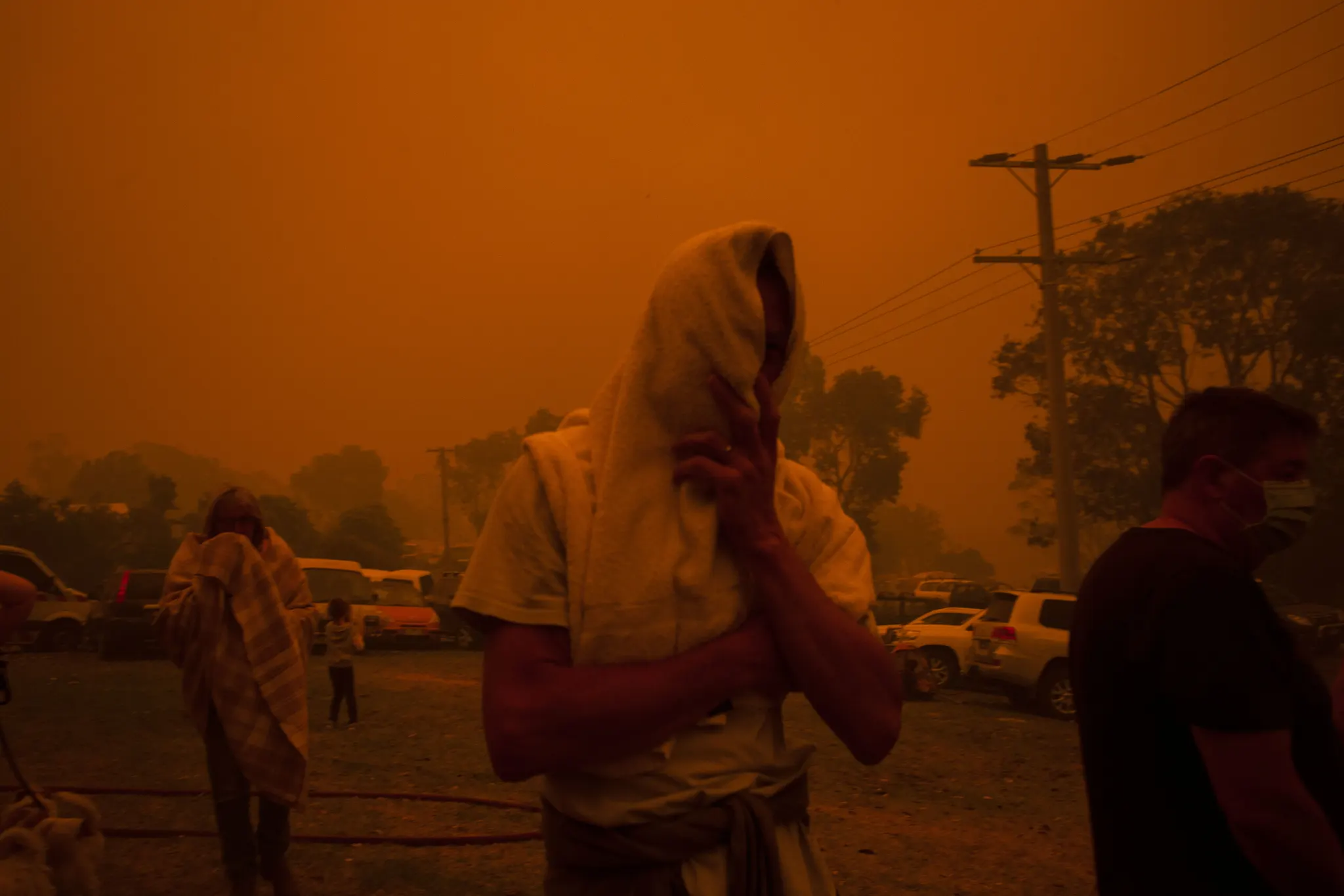
By Andrew Freedman 10 January 2020 (The Washington Post) – Australia’s bushfire crisis worsened Thursday night into Friday as hot, dry and windy conditions redeveloped across the country’s hard-hit southeast, causing two large blazes to merge into one. The new “megafire” measures about 1.5 million acres, about the size of the state of Delaware or […]

Social media & sharing icons powered by UltimatelySocial