A megafire measuring 1.5 million acres forms in Australia as bushfires merge – “It is too late to leave”
By Andrew Freedman
10 January 2020
(The Washington Post) – Australia’s bushfire crisis worsened Thursday night into Friday as hot, dry and windy conditions redeveloped across the country’s hard-hit southeast, causing two large blazes to merge into one. The new “megafire” measures about 1.5 million acres, about the size of the state of Delaware or roughly eight times as large as New York City.
“What we’re really seeing with a number of these fires merging is a number of small fires started by lightning strikes, across the landscape,” New South Wales Rural Fire Service spokesman Anthony Clark told the Sydney Morning Herald. “And as they grow, we see fires merging,” Clark said.
Separately, an emergency warning was issued for a blaze in the Southern Highlands region, known as the Morton Fire, that threatened populated areas. […]
The strong winds were reaching speeds of up to 55 mph, lofting embers out ahead of fires to start new spot fires, and propelling the front edges of fires forward at high rates of speed, breaching containment lines.
The emergency warning issued for the Morton Fire near Bundanoon advised residents to seek shelter, noting, “It is too late to leave.”
“Protect yourself from the heat of the fire,” the Rural Fire Service said.
Emergency warnings were also issued for fires in parts of Victoria.
Conditions were so extreme Friday morning that weather forecasters issued a severe thunderstorm warning for a fire-generated thunderstorm in northeastern Victoria, specifically for damaging winds. […]
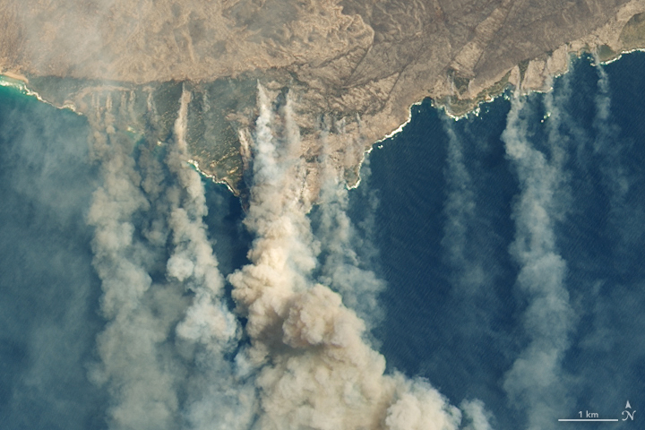
This is not the first megafire to form during Australia’s nightmarish bushfire season. The Gospers Mountain Fire near Sydney is also the result of multiple fires merging into one, and it has repeatedly sent thick, hazardous smoke into highly populated areas.
Scientists have published numerous studies showing that Australia’s climate is becoming hotter and drier because of human-caused climate change, and these trends are dramatically amplifying the risk of bushfires and lengthening the fire season. [more]
A ‘megafire’ measuring 1.5 million acres forms in Australia as bushfires merge