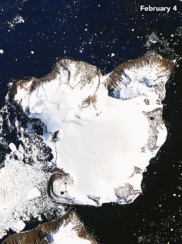
By Kasha Patel 21 February 2020 (NASA) – On 6 February 2020, weather stations recorded the hottest temperature on record for Antarctica. Thermometers at the Esperanza Base on the northern tip of the Antarctic Peninsula reached 18.3°C (64.9°F)—around the same temperature as Los Angeles that day. The warm spell caused widespread melting on nearby glaciers. The warm […]
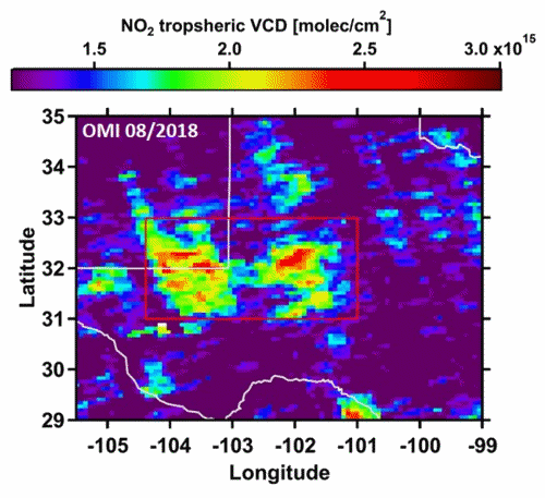
15 January 2020 (CIRES) – Oil and gas production has doubled in some parts of the United States in the last two years, and scientists can use satellites to see impacts of that trend: a significant increase in the release of the lung-irritating air pollutant nitrogen dioxide, for example, and a more-than-doubling of the amount […]
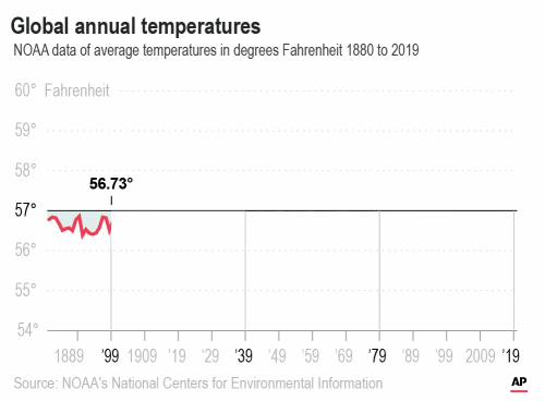
By Seth Borenstein 15 January 2020 WASHINGTON (AP) – The decade that just ended was by far the hottest ever measured on Earth, capped off by the second-warmest year on record, two U.S. agencies reported Wednesday. And scientists said they see no end to the way man-made climate change keeps shattering records. “If you think […]
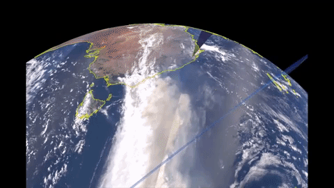
14 January 2020 (BBC News) – Smoke from the massive bushfires in Australia will soon circle the Earth back to the nation, says NASA. Massive infernos have raged along the nation’s east coast for months, pushing smoke across the Pacific. NASA said plumes from blazes around New Year’s Day had crossed South America, turning skies […]
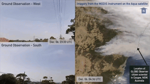
By Andrew Freedman 10 January 2020 (The Washington Post) – Australia’s bushfire crisis worsened Thursday night into Friday as hot, dry and windy conditions redeveloped across the country’s hard-hit southeast, causing two large blazes to merge into one. The new “megafire” measures about 1.5 million acres, about the size of the state of Delaware or […]
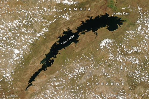
By Michael Carlowicz 17 December 2019 (NASA) – Southern Africa is suffering through its worst drought in several decades and perhaps a century. Diminished and late rainfall, combined with long-term increases in temperatures, have jeopardized the food security and energy supplies of millions of people in the region, most acutely in Zambia and Zimbabwe. According […]
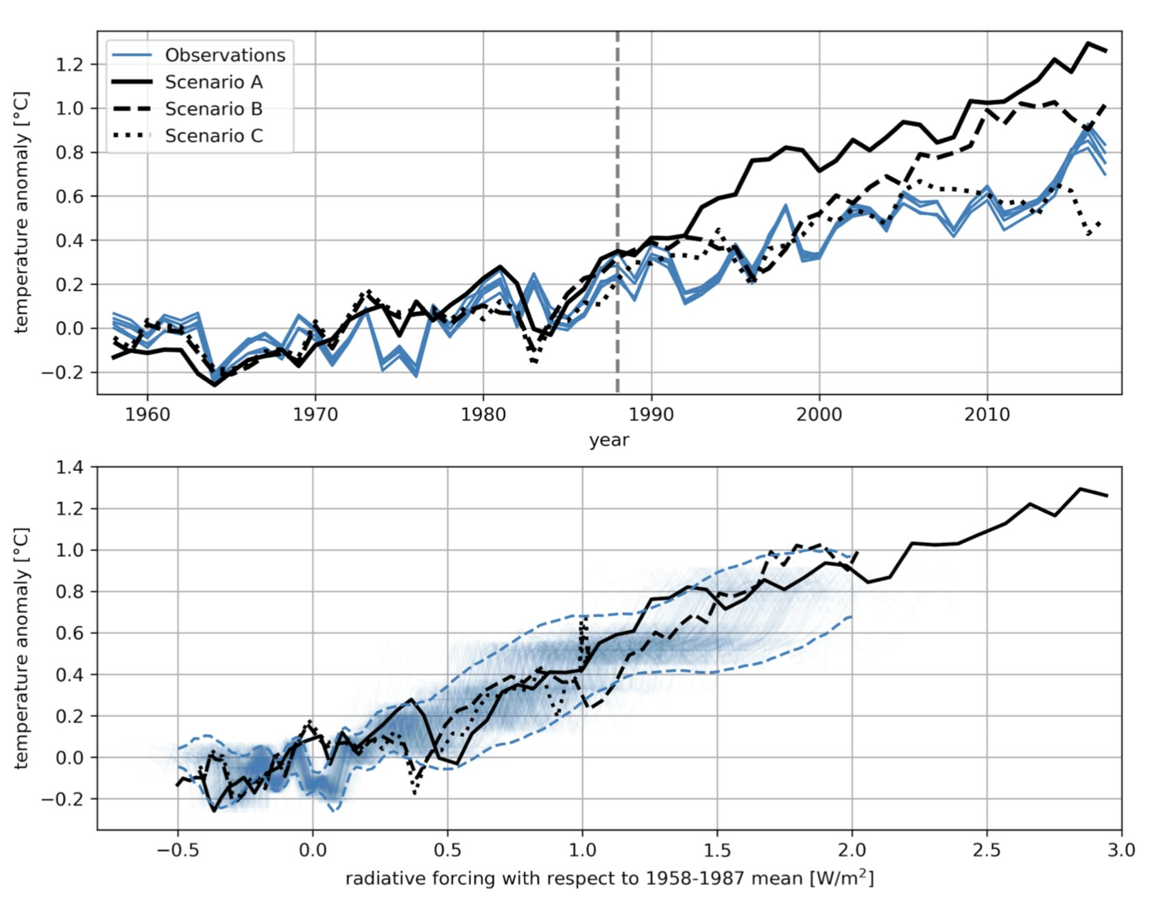
By Robert Sanders 4 December 2019 (Berkeley News) – Climate skeptics have long raised doubts about the accuracy of computer models that predict global warming, but it turns out that most of the early climate models were spot-on, according to a look-back by climate scientists at the University of California, Berkeley, Massachusetts Institute of Technology […]
By Carolyn Gramling 10 December 2019 SAN FRANCISCO (Science News) – A mesmerizing new series of images shows the retreat of Alaska’s Columbia glacier over the last 47 years in gorgeous, excruciating detail. The images were presented December 10 at the American Geophysical Union’s annual meeting. Landsat satellites operated by NASA and the U.S. Geological […]
10 December 2019 (Utrecht University) – Greenland is losing ice seven times faster than in the 1990s and is tracking the IPCC’s high-end climate warming scenario, which would see 40 million more people exposed to coastal flooding by 2100. The findings, published in Nature today, show that Greenland has lost 3.8 trillion tonnes of ice […]
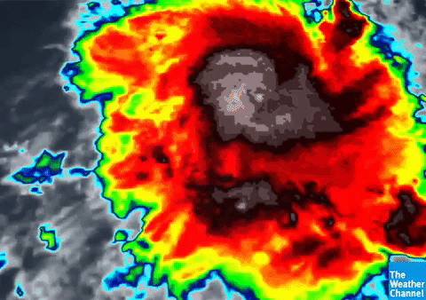
By Bob Henson 6 December 2019 (Weather Underground) – Barely a tropical storm on Wednesday night EST, Tropical Cyclone Ambali astounded weather watchers on Thursday as it pole-vaulted to the brink of Category 5 strength in the southwest Indian Ocean, counter to nearly all expectations. Ambali’s top sustained winds, as assessed from satellite data by […]