Two tropical cyclones set records in one week: Ambali has fastest intensification on record south of the equator, and Kammuri has tallest, coldest cloud tops ever
By Bob Henson
6 December 2019
(Weather Underground) – Barely a tropical storm on Wednesday night EST, Tropical Cyclone Ambali astounded weather watchers on Thursday as it pole-vaulted to the brink of Category 5 strength in the southwest Indian Ocean, counter to nearly all expectations. Ambali’s top sustained winds, as assessed from satellite data by the Joint Typhoon Warning Center, jumped from 35 knots (40 mph) at 0Z Thursday to 135 knots (155 mph) at 0Z Friday. This increase of 100 knots is the largest 24-hour intensification on record in the Southern Hemisphere, breaking the record of 95 knots (110 mph) from Cyclone Ernie in 2017. It falls just short of the world record set by Hurricane Patricia in 2015 of 105 knots (120 mph).
Ambali was ramping down on Friday almost as quickly as it cranked up. As of 12Z Friday, Ambali’s top winds were already back down to 90 knots (105 mph), making it a Category 2 storm. JTWC predicted that Ambali will weaken to a tropical storm by 12Z Saturday, then slowly dissipate several hundred north of La Reunion and Mauritius. […]
There’s also a bigger context in play that gave Ambali a boost. The cyclone is just one part of a remarkable burst of activity in the western Indian Ocean. On Friday morning, Ambali was one of four tropical systems splayed across the western Indian Ocean—two north of the equator and two south of it.
Dr. Jeff Masters sent me these comments:
“Experiencing four simultaneous tropical cyclones or tropical disturbances in the Arabian Sea and the mirror image portion of the South Indian Ocean, south of the equator, is certainly a rare occurrence—and one possibly unmatched in the satellite era. We’ve basically crammed in all of the tropical systems that can possibly fit into that limited area of ocean! We know it is rare to see two simultaneous named tropical cyclones in the northern hemisphere’s Arabian Sea. According to the India Meteorological Department, that has occurred only once in recorded history—in October 2019, when Cyclone Kyarr and Cyclone Maha were both active simultaneously.” [more]
Ambali Drops the Mic: Fastest Intensification on Record South of the Equator
Typhoon Kammuri sweeps through Philippines; coldest cloud tops on record
By Bob Henson
3 December 2019
(Weather Underground) – At least four deaths have been reported from Typhoon Kammuri, which moved off the coast of the Philippines’ Mindanao island on Tuesday night local time after thrashing the central part of the nation with winds topping 100 mph. The strongest storm to hit the Philippines in 2019, Kammuri made landfall Monday night just after peaking at Category 4 strength, according to the Joint Typhoon Warning Center. The typhoon was referred to as Tisoy in the Philippines. […]
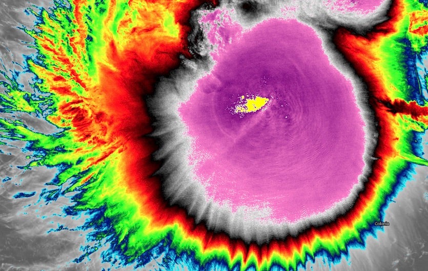
Kammuri may have earned a distinctive place in tropical cyclone history—not because of its impacts in the Philippines, but from its behavior several days earlier. While still a Category 1 typhoon well east of the Philippines, Kammuri was generating exceptionally strong convection, with storms extending high enough in the atmosphere to produce extremely cold cloud tops. At 0420Z on Saturday, 30 November 2019, the Visible Infrared Imaging Radiometer Suite (VIIRS) aboard the NOAA-20 satellite detected a cloud-top infrared brightness temperature just west of Kammuri’s center of –109.4°C (–164.9°F). According to Mark Lander (University of Guam), this appears to be the only cloud-top temperature on record known to exceed by a wide margin the world record reported by Elizabeth Ebert and Greg Holland in 1992 of–102.2°C (–148°F) from Tropical Cyclone Hilda east of Australia in 1990. […]
According to an email from Bachmeier, Kris Bedka (formerly at CIMSS, now at NASA Langley Research Center) estimated that the cloud tops producing the record-cold brightness temperature were at a height of around 12.1 miles (19.5 kilometers). For more details on this record-setting event, see the post from Bachmeier at the CIMSS Satellite Blog. [more]
Kammuri Sweeps Through Philippines; Coldest Cloud Tops on Record

