Satellite view of the Valdecañas Reservoir in Spain, on 24 July 2013 and 25 July 2019. The record heatwave and extreme drought of 2019 revealed the lost “Spanish Stonehenge”, the Dolmen of Guadalperal. Photo: Lauren Dauphin / NASA Earth Observatory

Record heatwave and extreme drought reveal lost “Spanish Stonehenge”

By Kasha Patel 19 September 2019 (NASA) – In 1963, the Spanish government under Francisco Franco built the Valdecañas Reservoir in order to bring water and electricity to underdeveloped parts of western Spain. However, the creation of the reservoir flooded some inhabited areas as well as large stone (megalithic) monuments. After fifty years underwater, one […]

Satellite view of Gondwana rainforest fires, 4-15 September 2019. Photo: NASA Worldview

Drought exacerbates wildfires in Australia rainforest

By Michael Carlowicz 14 September 2019 (NASA) – Fire season in the Australian states of Queensland and New South Wales got off to an early and ugly start in September 2019. Fueled by a long and deepening drought, more than 100 fires burned in forest and bush areas near the southeast coasts, including some subtropical […]

August 2019 Blended Land and Sea Surface Temperature Anomalies in degrees Celsius. Graphic: NOAA

Summer 2019 in the Northern Hemisphere tied for warmest summer on record – Five hottest NH summers have occurred in the past five years

By Andrew Freedman 16 September 2019 (The Washington Post) – The Northern Hemisphere just had its hottest summer on record since 1880, according to National Oceanic and Atmospheric Administration data released Monday. NOAA found the average global surface temperature taken by thousands of thermometers, buoys and other sensors on land and sea tied with that of 2016 […]

Map showing active fire detections in the Amazon rainforest in Brazil as observed by Terra and Aqua MODIS satellites between 15 August 2019 and 22 August 2019. Photo: Joshua Stevens / NASA Earth Observatory

NASA satellites confirm Amazon rainforest is burning at a record rate

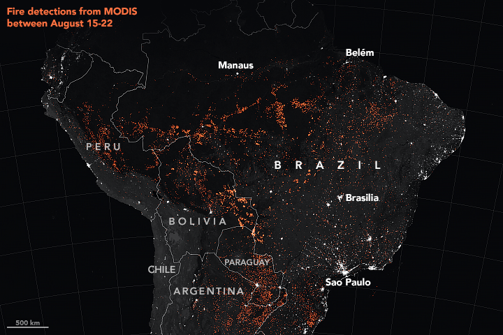
By Passant Rabie 27 August 2019 (Space.com) – As raging fires continue to sweep through the Amazon rainforest in Brazil, NASA satellites and astronauts aboard the International Space Station are tracking the flames from above. Their view confirmed that this is the most active fire year in Brazil since 2010. Fire detections by NASA’s Moderate Resolution Imaging Spectroradiometer (MODIS) […]

Satellite view of Hurricane Dorian making landfall on the Bahamas, 1 September 2019. This view is one of the strongest landfalls ever captured on satellite. Photo: Dakota Smith / NCAR

Hurricane Dorian strikes Bahamas with record fury as Category 5 storm – “The winds are howling like we’ve never, ever experienced before”

By Ramón Espinosa 1 September 2019 McLEAN’S TOWN CAY, Bahamas (AP) – Hurricane Dorian struck the northern Bahamas as a catastrophic Category 5 storm Sunday, its record 185 mph winds ripping off roofs, overturning cars and tearing down power lines as hundreds hunkered down in schools, churches and shelters. Dorian slammed into Elbow Cay in […]

The Moderate Resolution Imaging Spectroradiometer (MODIS) on NASA’s Aqua satellite captured these images of several fires burning in the states of Rondônia, Amazonas, Pará, and Mato Grosso on 13 August 2019. Data: MODIS data from NASA EOSDIS/LANCE and GIBS/Worldview and VIIRS data from NASA EOSDIS/LANCE and GIBS/Worldview, and the Suomi National Polar-orbiting Partnership Photo: Lauren Dauphin / NASA Earth Observatory

Image of the Day: Satellite view of forest-clearing fires in the Amazon, August 2019

By Adam Voiland 16 August 2019 (NASA) – In the Amazon rainforest, fire season has arrived. The Moderate Resolution Imaging Spectroradiometer (MODIS) on NASA’s Aqua satellite captured these images of several fires burning in the states of Rondônia, Amazonas, Pará, and Mato Grosso on August 11 and August 13, 2019. In the Amazon region, fires are rare for much […]

Excitation near the saddle-node bifurcation and steady-state solutions for global carbon cycle model. Graphic: Rothman, 2019 / PNAS

Breaching carbon threshold could lead to mass extinction – Carbon dioxide emissions may trigger “reflex” in global carbon cycle, with devastating consequences

By Jennifer Chu 8 July 2019 (MIT News) – In the brain, when neurons fire off electrical signals to their neighbors, this happens through an “all-or-none” response. The signal only happens once conditions in the cell breach a certain threshold. Now an MIT researcher has observed a similar phenomenon in a completely different system: Earth’s […]

Large rivers of melting water form on an ice sheet in western Greenland on 1 August 2019 and drain into moulin holes that empty into the ocean from underneath the ice. The heat wave that smashed high temperature records in five European countries a passed over Greenland, accelerating the melting of the island's ice sheet and causing massive ice loss in the Arctic. Photo: Caspar Haarløv / Into the Ice / AP

Bizarre happenings in the Arctic: Lightning, tropical moisture, and more

By Bob Henson 14 August 2019 (Weather Underground) – You’ll have to forgive the Arctic. It’s had a rough summer. Sea ice is running neck and neck with 2012 for the lowest values on record for this time of year. Wildfires are ringing the Arctic, pouring more carbon dioxide into the air than in any comparable period in 17 […]

Animation showing the concentration of black carbon particulates — commonly called soot — around the Arctic from 1 July 2019 to 29 July 2019. Graphic: Lauren Dauphin / NASA Earth Observatory

Arctic fires fill Northern Hemisphere skies with soot

By Kasha Patel 1 August 2019 (NASA) – In June and July 2019, more than 100 long-lived and intense wildfires blazed within the Arctic Circle. Most of them burned in Alaska and Siberia, though a few raged even in Greenland. As these fires lofted thick plumes of smoke into the skies, they also launched megatons of tiny, harmful particles into the […]

Remote sensing imagery of discolored water and algal blooms in the Florida Bay and the Florida Keys region between 1992 and 2013 showing connectivity of the mainland and the lower Florida Keys, all outlined in red. (a) Landsat true color image on 29 May 1992 shows turbid water in western Florida Bay and discolored, black water in central Florida Bay that extends southward to the lower Florida Keys; (b) AVHRR reflectance image on 12 March 1996 shows high turbidity from the Shark River Slough plume extending beyond the lower Florida Keys towards Dry Tortugas; (c, d) VIIRS chlorophyll a anomaly images show phytoplankton blooms off Shark River Slough reaching the lower Florida Keys that were partially composed of the cyanobacterium, Synechococcus, on (c) 24 November 2013 and (d) 27 January 2014. Graphic: Lapointe, et al., 2019 / Marine Biology

Nutrient loading lowers resistance to thermal stress in Florida Keys corals – “These data make clear that this is not an ‘either temperature or nutrients’ situation, but rather a ‘both/and’ combination of multiple stressors”

By Gisele Galoustian 15 July 2019 (FAU) – Coral reefs are considered one of the most threatened ecosystems on the planet and are dying at alarming rates around the world. Scientists attribute coral bleaching and ultimately massive coral death to a number of environmental stressors, in particular, warming water temperatures due to climate change. A […]

Social media & sharing icons powered by UltimatelySocial