Hurricane Dorian strikes Bahamas with record fury as Category 5 storm – “The winds are howling like we’ve never, ever experienced before”
By Ramón Espinosa
1 September 2019
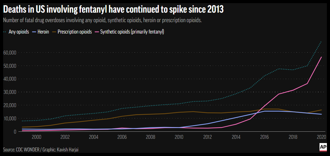
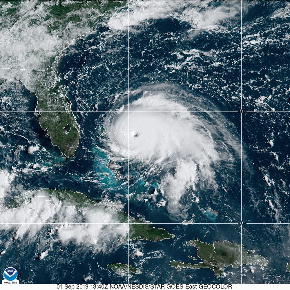
McLEAN’S TOWN CAY, Bahamas (AP) – Hurricane Dorian struck the northern Bahamas as a catastrophic Category 5 storm Sunday, its record 185 mph winds ripping off roofs, overturning cars and tearing down power lines as hundreds hunkered down in schools, churches and shelters.
Dorian slammed into Elbow Cay in the Abaco Islands at 12:40 p.m., and then made a second landfall near Marsh Harbour on Great Abaco Island at 2 p.m., after authorities made last-minute pleas for those in low-lying areas to evacuate.
“It’s devastating,” said Joy Jibrilu, director general of the Bahamas’ Ministry of Tourism and Aviation. “There has been huge damage to property and infrastructure. Luckily, no loss of life reported.”
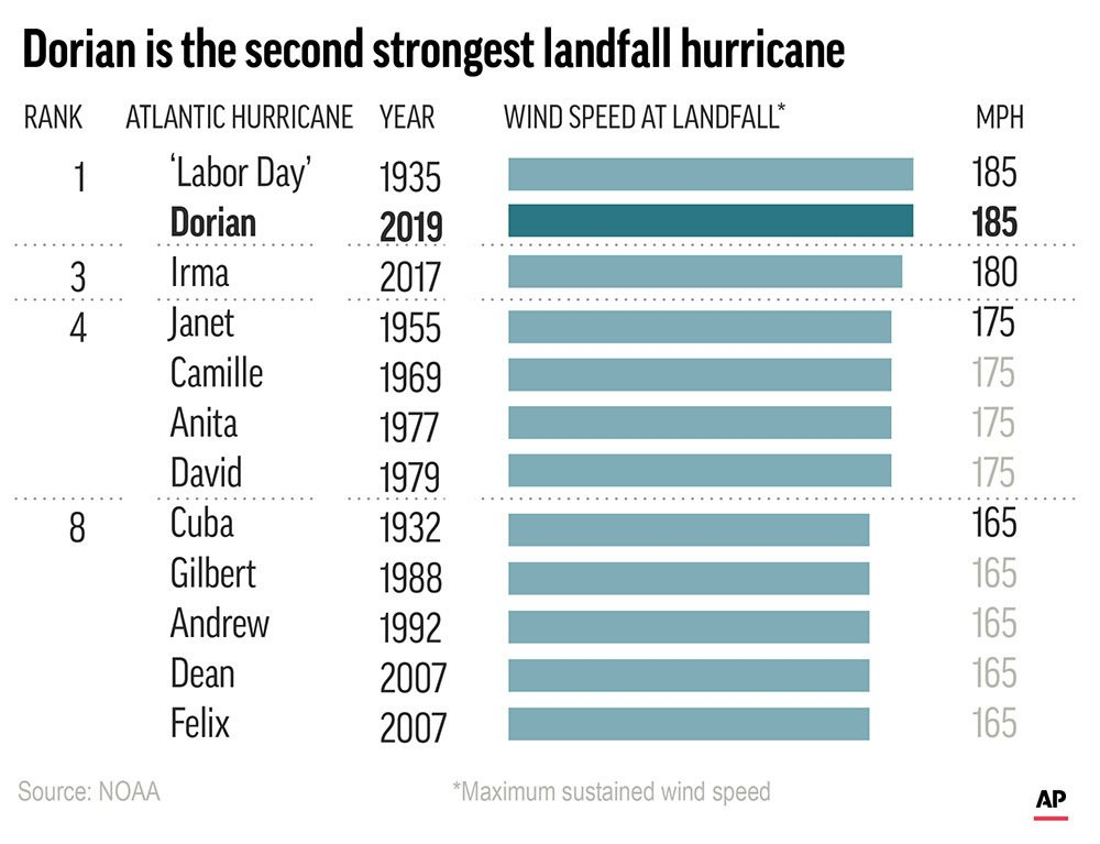
With its maximum sustained winds of 185 mph (295 kph) and gusts up to 220 mph, Dorian tied the record for the most powerful Atlantic hurricane ever to come ashore, equaling the Labor Day hurricane of 1935, before the storms were named.
Millions from Florida to the Carolinas kept a wary eye on the slow-moving Dorian amid indications it would veer sharply northeastward after passing the Bahamas and track up the U.S. Southeast seaboard. But authorities warned that even if its core did not make U.S. landfall, the potent storm would likely hammer the coast with powerful winds and heavy surf.
The only recorded storm that was more powerful was Hurricane Allen in 1980, with 190 mph winds. That storm did not make landfall at the strength.
“Catastrophic conditions” were reported in the Abaco Islands, with a storm surge of 18-23 feet, and Dorian was expected to cross Grand Bahama later in the day “with all its fury,” the center said. The hurricane was moving to the west at 5 mph (7 kph).
In the northern stretches of the archipelago, hotels closed, residents boarded up homes and officials hired boats to move people to bigger islands.
Video that Jibrilu and government spokesman Kevin Harris said was sent by Abaco residents showed homes missing parts of their roofs, downed power lines and smashed and overturned cars. One showed floodwaters rushing through the streets of an unidentified town at nearly the height of a car roof.
In some parts of Abaco, “you cannot tell the difference as to the beginning of the street versus where the ocean begins,” said Prime Minister Hubert Minnis.
According to the Nassau Guardian, he called it “probably the most sad and worst day of my life to address the Bahamian people.”
Earlier, Minnis had warned that anyone who did not evacuate was “in extreme danger and can expect a catastrophic consequence.”
The government opened 14 shelters across the Bahamas. Dozens ignored evacuation orders, officials said.
“The end could be fatal,” said Samuel Butler, assistant police commissioner. “We ask you, we beg you, we plead with you to get to a place of safety.”
Bahamas radio station ZNS Bahamas reported a mother and child in Grand Bahama called to say they were sheltering in a closet and seeking help from police.
Silbert Mills, owner of the Bahamas Christian Network, said trees and power lines were torn down in The Abaco Islands.
“The winds are howling like we’ve never, ever experienced before,” said Mills, 59, who planned to ride out the hurricane with his family in the concrete home he built 41 years ago in central Abaco.
Among those refusing to leave were 32 people in Sweetings Cay, a fishing town of a few hundred people about 5 feet (1.5 meters) above sea level, and a group that sought safety in Old Bahama Bay resort, which officials said was not safe. […]
Over two or three days, the hurricane could dump as much as 4 feet (1 meter) of rain, in addition to the winds and storm surge, said private meteorologist Ryan Maue. […]
National Hurricane Center Director Ken Graham urged residents not to bet on safety just because the specific forecast track has the storm just a bit offshore. Don’t focus on the track, he said, but the larger cone of possibility that includes landfall. [more]
Dorian strikes Bahamas with record fury as Category 5 storm
Historic, catastrophic Hurricane Dorian pounding the Bahamas with 185 mph winds
By Dr. Jeff Masters
1 September 2019
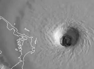
(Weather Underground) – Catastrophic Category 5 Hurricane Dorian made landfall in Elbow Cay in The Bahamas at 12:40 pm EDT Sunday with 185 mph winds, gusting to 220 mph, making it the strongest landfalling Atlantic hurricane on record. In the 8-hour period ending at 12:45 pm EDT Sunday, Dorian put on a rare show of rapid intensification—its already-formidable 150 mph winds increased to 185 mph, and the central pressure dropped from 934 to 911 mb.
Dorian’s forward speed of 8 mph this morning is expected to slow to just 4 mph tonight, causing an unprecedented long-duration battering of The Bahamas by one of the most extreme hurricanes in history. On Great Abaco and Little Abaco islands, hurricane-force winds will likely blow for 12 – 15 consecutive hours, interrupted only by the passage of the calm eye. For several hours, Category 5 winds in excess of 160 mph are likely, which will be capable of destroying all but the most rigorously designed concrete steel-reinforced structures. Dorian may wobble enough to the northwest to prevent Grand Bahama Island from receiving such a long pounding, but that island is still likely to experience extreme damage.
Dorian is now tied for having the second-highest winds of any Atlantic hurricanes on record:
1. 190 mph (Allen 1980)
2. 185 mph (Dorian 2019, Labor Day 1935, Gilbert 1988, Wilma 2005)
3. 180 mph (Mitch 1998, Rita 2005, Irma 2017)
4. 175 mph (11 storms, including Maria 2017, Katrina 2005, Andrew 1992, Camille 1969)
Dorian is tied for strongest landfalling Atlantic hurricane on record:
1. 185 mph: Dorian 2019 (Bahamas), Labor Day 1935 (Florida Keys)
2. 180 mph: Irma 2017 (Barbuda, St. Martin, British Virgin Islands)
3. 175 mph: Camille 1969 (Mississippi), Janet 1955 (Mexico), Dean 2007 (Mexico), David 1979 (Dominican Republic), Anita 1977 (Mexico)
Dorian’s lowest central pressure value of 911 mb at of 12:45 pm EDT Sunday does not yet make the top ten list of strongest Atlantic hurricanes by pressure; to make that list, Dorian would have to match the 908 mb pressure of Hurricane Maria (2017).
Dorian is the fifth Cat 5 in the Atlantic since 2016, joining Michael (2018), Irma (2017), Maria (2017), and Matthew (2016). This makes 2019 the fourth year in a row the Atlantic basin has had at least one hurricane reach Cat 5 strength, beating the previous record, a three-year stretch from 2003 to 2005. Including Dorian, there have been 35 Category 5 hurricanes in the Atlantic Basin, according to the National Oceanic and Atmospheric Administration (NOAA). [more]
Historic, Catastrophic Hurricane Dorian Pounding The Bahamas With 185 mph Winds