Record heatwave and extreme drought reveal lost “Spanish Stonehenge”

By Kasha Patel
19 September 2019
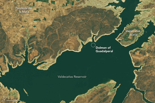
(NASA) – In 1963, the Spanish government under Francisco Franco built the Valdecañas Reservoir in order to bring water and electricity to underdeveloped parts of western Spain. However, the creation of the reservoir flooded some inhabited areas as well as large stone (megalithic) monuments. After fifty years underwater, one of these ancient monuments—the Dolmen of Guadalperal—resurfaced due to dry, hot conditions in 2019.
The Operational Land Imager on Landsat 8 acquired images showing the dry conditions along the Peraleda de la Mata coast. The left image was acquired on 24 July 2013, while the right image comes from 25 July 2019. Note the changing water levels and the widening of the tan ring around the shoreline; these lighter colored sediments are the recently exposed lake bottom. A circle marks the area where the remains of the Dolmen of Guadalperal are said to appear.
Several areas of Europe experienced drought conditions during the summer of 2019. Much of the continent endured two heatwaves with record-breaking temperatures in June and July. Spain, in particular, faced its third-driest June this century, with above average temperatures in July and August. Many crops wilted, affecting many farmers.
The drought conditions were enough to expose the Dolmen of Guadalperal, according to news reports. Dubbed the “Spanish Stonehenge,” the monument is a circle of more than 100 standing rocks dating back to 7,000 years ago. Archeologists believe it was originally constructed as an enclosed space—a large stone house with a cap. The dolmen could have served as a tomb, a site for religious rituals, or a trading hub since it was relatively easy to cross the river at this location. The most recent recorded exploration and excavation of the site was by German archaeologist Hugo Obermaier in the 1920s. By the time Obermaier’s findings were published in the 1960s though, Valdecañas Reservoir was filled, submerging history with water.
Since the 1960s, tips of the tallest megaliths have peaked out of the lake as water levels fluctuated. However, the dry, hot conditions in 2019 dropped lake levels to a point where the entire structure for the first time since the reservoir was filled. The image above shows the remains of the standing stones in July 28, 2019.
A group of local residents have petitioned to relocate the stones in order to preserve the ancient structure. Originally constructed from granite that was likely transported from miles away, the stones are porous and already falling over, cracking, and eroding. Locals believe the monument could help tourism in the area, offering the dolmen as a window into Spain’s ancient history. For instance, the most notable feature is a large stone that marks its entrance and features a squiggly line. Some believe it is a map of the Tagus River, which would make it one of the oldest maps on Earth.