Ducks swim through an algae bloom in Santuit Pond in Cape Cod, Massachusetts, in July 2018. Photo: Steve Heaslip / The Cape Cod Times / Associated Press

A toxic stew on cape cod: Human waste and warming water

By Christopher Flavelle 1 January 2023 MASHPEE, Massachusetts (The New York Times) – Ashley K. Fisher walked to the edge of the boat, pulled on a pair of thick black waders, and jumped into the river to search for the dead. She soon found them: the encrusted remains of ribbed mussels, choked in gray-black goo […]

Number of Western Monarch butterflies (left) and butterfly surveys (right), 1997-2021. In the western United States, the number of individual butterflies has been steadily decreasing over the past four decades, at a rate of around 1.6% every year, according to a March 2021 study in the journal Science. The iconic Monarch butterfly is one of the species in trouble. Warmer autumn temperatures, an effect of climate change, may be interfering with the butterflies’ hibernation-like period known as diapause. So rather than slowing down ahead of winter, the insects are staying awake longer, expending more energy, and eventually starving to death. In July 2022, the migratory monarch was added to the IUCN’s global endangered species list. Graphic: Catherine Tai / Reuters

The collapse of insects – “They’re the fabric tethering together every freshwater and terrestrial ecosystem across the planet”

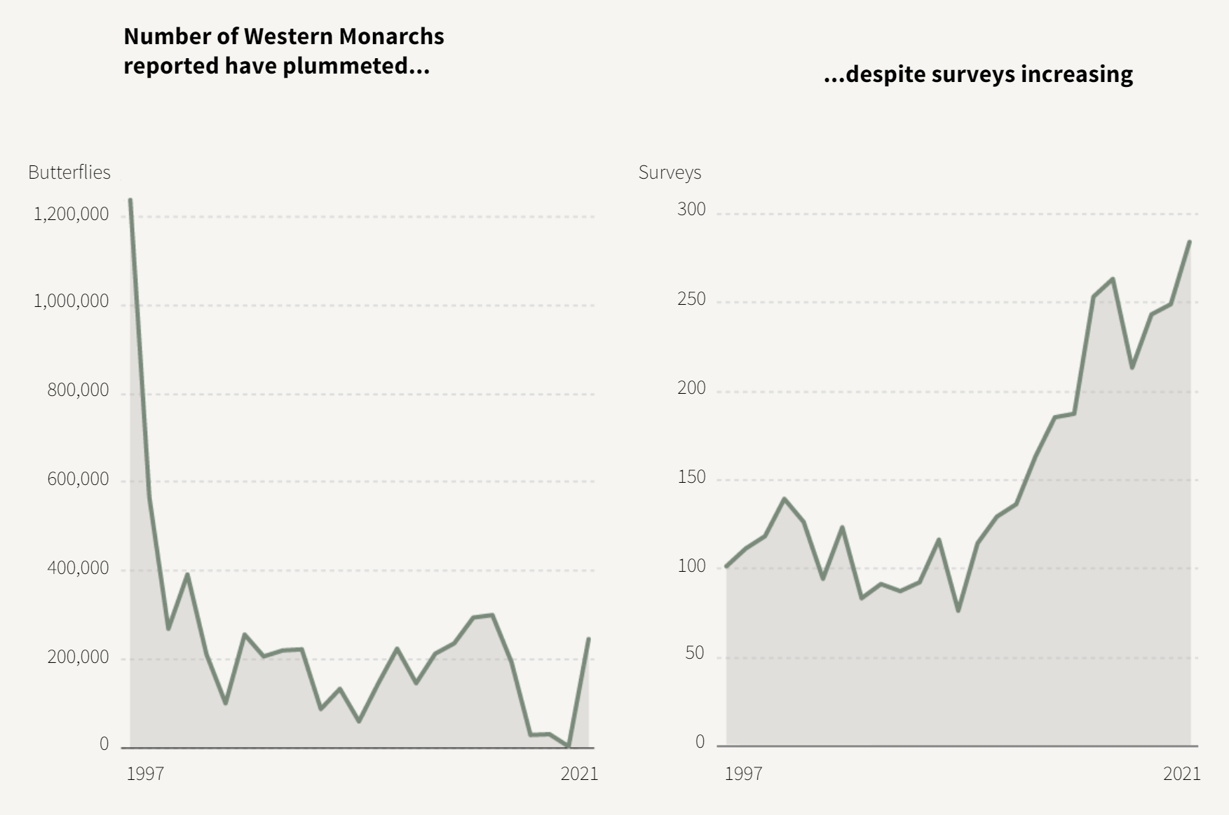
By Julia Janicki, Gloria Dickie, Simon Scarr and Jitesh Chowdhury 6 December 2022 (Reuters) – As a boy in the 1960s, David Wagner would run around his family’s Missouri farm with a glass jar clutched in his hand, scooping flickering fireflies out of the sky. “We could fill it up and put it by our […]

Police monitor a protest opposing COP15, the UN Biodiversity Conference, in Montreal, on Wednesday, 7 December 2022. Photo: Graham Hughes / The Canadian Press

Monbiot: The US is a rogue state leading the world toward ecological collapse – “It’s a cliff edge”

By George Monbiot 9 December 2022 (The Guardian) – There are two extraordinary facts about the convention on biological diversity, whose members are meeting in Montreal now to discuss the global ecological crisis. The first is that, of the world’s 198 states, 196 are party to it. The second is the identity of those that aren’t. Take a […]

Aerial view of apparent red tide and other phytoplankton species in the water near Naples and Sanibel, Florida on 13 November 2022. According to the Florida Fish and Wildlife Conservation Commission, beaches from Sarasota to Port Charlotte varied between low, medium, and high levels of red tide. Because Hurricane Ian brought so much rain to Florida in October, scientists on the coast closely monitored water quality to see if the storm had any impacts. Photo: Ralph Arwood / Calusa Waterkeeper

Photos show toxic algae blooms plaguing southwest Florida waters – Runoff from Hurricane Ian suspected

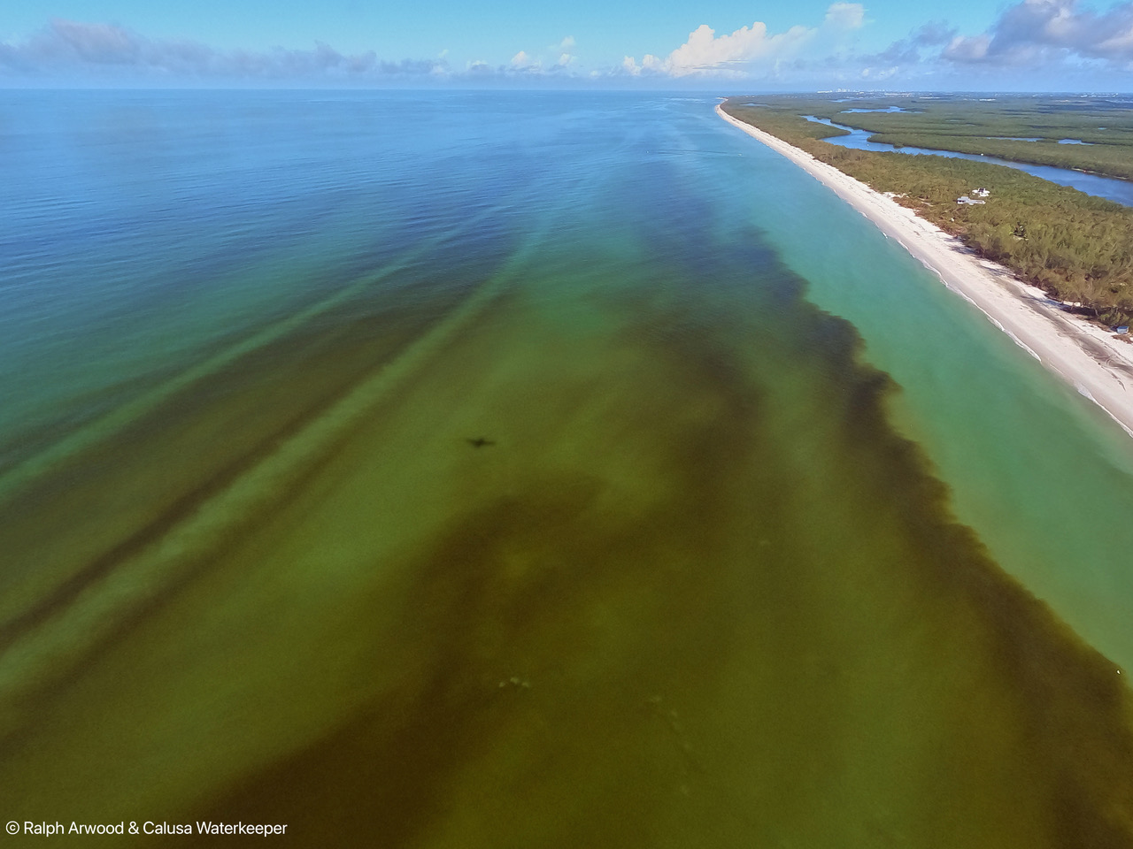
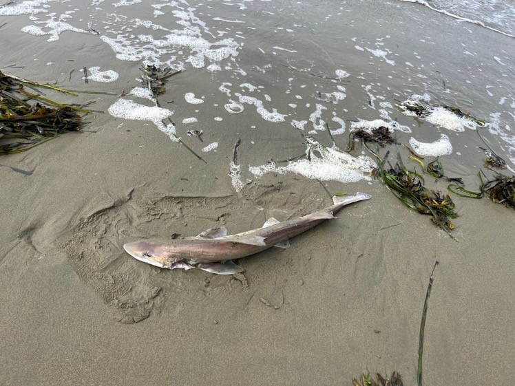
By Dylan Abad 14 November 2022 TAMPA, Florida (WFLA) – Aerial photos revealed massive plumes of red tide stretching along much of southwest Florida’s coast days after Tropical Storm Nicole passed over the state. Photos released by Calusa Waterkeeper showed a deep reddish-brown discoloration of the water near Naples and Sanibel due to the presence […]

What appears to be a shark washed up on Keller Beach in Point Richmond on 24 August 2022. Photo: William Fitzgerald

Environmental group reports “unprecedented” algae bloom, fish dying across SF Bay – “This appears to be a substantial fish kill, most likely related to the unprecedented red tide algal bloom we have been tracking for the past month”

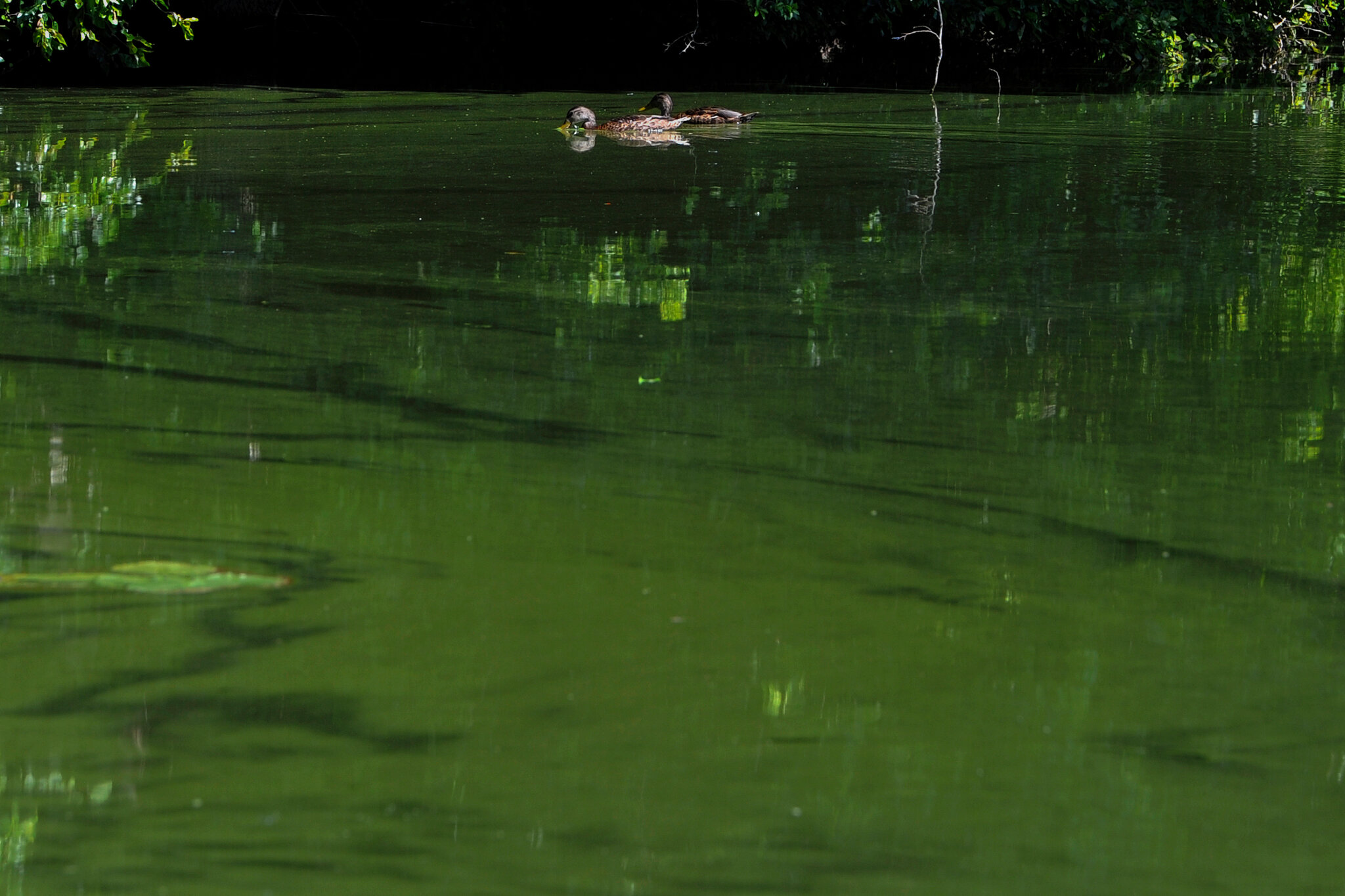
By Alyssa Goard 28 August 2022 (Bay City News) – Environmental nonprofit San Francisco Baykeeper is reporting that an algae bloom is happening across the San Francisco Bay, something they believe is unprecedented in the history of the bay. Additionally, in the past week Baykeeper said it’s received an increasing number of reports of dead […]

Projections of annual counts of high-tide flooding (HTF) days for the NOAA Intermediate Sea Level Rise (SLR) scenario. The NOAA minor flooding threshold is used for Honolulu, San Diego and St. Petersburg. The NOAA moderate flooding threshold is used for Boston to highlight a threshold that is not yet routinely exceeded, which is not the case for the Boston minor threshold. The 50th percentile from the ensemble of projections (blue line) and the 10th–90th percentile range (blue shading, with the 90th percentile highlighted in orange) show increasing numbers of HTF days per year. The year of inflection (YOI, open black circle) for each projection corresponds to abrupt increases in the frequency of HTF days, which are highlighted by comparing the projected increases (Δ) over two adjacent ten-year periods (dashed and solid black lines). Graphic: Thompson, et al., 2021 / Nature Climate Change

Sunny-day flooding is about to become more than a nuisance – “What’s scary about this paper is the idea of the inflection point. Can we adapt fast enough to keep pace?”

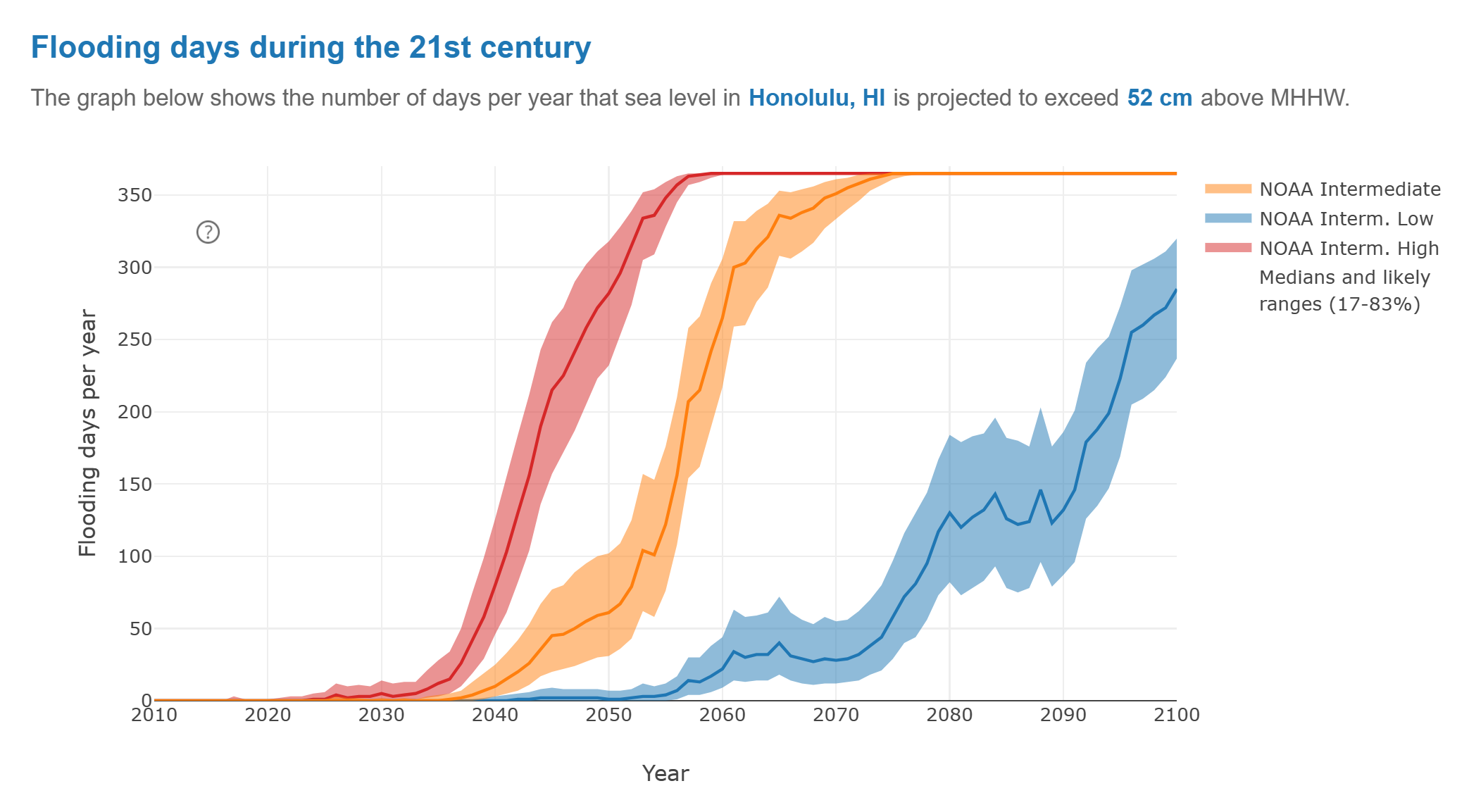
By Jim Morrison 2 August 2021 (WIRED) – During the summer of 2017, the tide rose to historic heights again and again in Honolulu, higher than at any time in the 112 years that records had been kept. Philip Thompson, director of the Sea Level Center at the University of Hawaii, wanted to know why. […]

Satellite view of tropospheric NO2 VCDs over the Permian basin for August 2018, seen from the Ozone Monitoring Instrument (OMI) and Tropospheric Monitoring Instrument (TROPOMI) aboard NASA and ESA satellites. OMI has a ground pixel size of 13 x 24 km2 and was gridded onto a 0.07 by 0.07 degrees latitude/longitude grid. TROPOMI has a footprint of 3.5 x 7 km2 and was averaged onto a 0.02 by 0.02 degrees latitude/longitude grid. The increased spatial resolution of the TROPOMI measurements is clearly visible. The red outline denotes the area used for the multivariate regression fits. Graphic: Dix, et al., 2020 / Geophysical Research Letters

Air pollution from oil and gas production sites visible from space – U.S. and European satellites help scientists measure nitrogen dioxide from drilling, production, and flaring

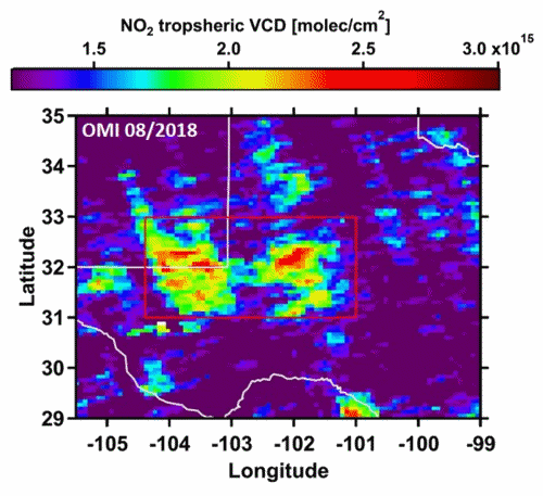
15 January 2020 (CIRES) – Oil and gas production has doubled in some parts of the United States in the last two years, and scientists can use satellites to see impacts of that trend: a significant increase in the release of the lung-irritating air pollutant nitrogen dioxide, for example, and a more-than-doubling of the amount […]

Global pattern in the cumulative development of coastal hypoxia in the periods before 1969, 1970-1989, and 1990-2015. Each red dot represents a documented case related to human activities. Green dots are sites that have improved. Since the 1960s, the global number of hypoxic systems has about doubled every ten years up to 2000. Data: Based on Diaz and Rosenberg (2008), Diaz, et al. (2010), and Conley et al. (2011). Graphic: Laffoley and Baxter, 2019 / IUCN

Oceans losing oxygen at unprecedented rate, experts warn

By Fiona Harvey 7 December 2019 MADRID (The Guardian) – Oxygen in the oceans is being lost at an unprecedented rate, with “dead zones” proliferating and hundreds more areas showing oxygen dangerously depleted, as a result of the climate emergency and intensive farming, experts have warned. Sharks, tuna, marlin and other large fish species were […]

This animation depicts the abundance and direction of black carbon blowing through the atmosphere from 1 November 2019 to 18 November 2019. The data for the animation come from the GEOS forward processing (GEOS-FP) model, which assimilates information from satellite, aircraft, and ground-based observing systems. Video: Joshua Stevens / NASA Earth Observatory

Smoke plumes from Australia bushfires crossing oceans

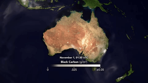
By Michael Carlowicz and Adam Voiland 21 November 2019 (NASA) – Three weeks into November 2019, springtime bush fires continued to blaze across southern and eastern Australian states. As of November 20, government agencies counted 45 fires in South Australia and 49 in New South Wales, and dangerously dry and windy weather was fanning flames […]

Map of air pollution in India showing Air Quality Index meters maxed at 999 on 3 November 2019. Graphic: AQICN

India air pollution deteriorates to “hazardous” rating – “Pollution has reached unbearable levels across North India”

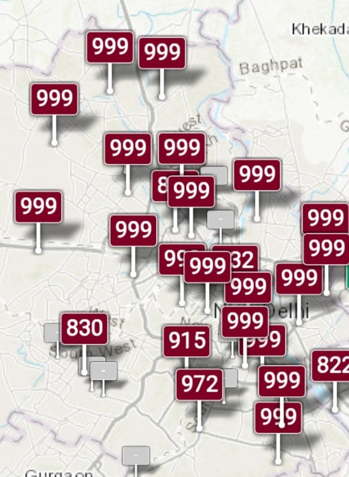
3 November 2019 (BBC News) – Air pollution in the north of India has “reached unbearable levels,” the capital Delhi’s Chief Minister Arvid Kejriwal says. In many areas of Delhi air quality deteriorated into the “hazardous” category on Sunday with the potential to cause respiratory illnesses. Authorities have urged people to stay inside to protect […]

Social media & sharing icons powered by UltimatelySocial