Hubei’s Guanyin Pavilion during the July 2017 flood and the August 2022 drought. Photo: Getty Images

Climate change has come for the world’s largest greenhouse gas emitter – “There is nothing in world climatic history which is even minimally comparable to what is happening in China”

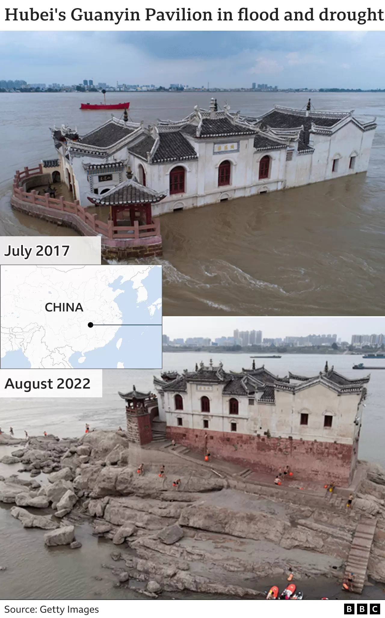
By Muizz Akhtar 29 September 2022 (Vox) – China just finished one of its most disastrous summers on record, with record-breaking heat, drought, and wildfires leading to water shortages even into the fall. More than 900 million people — or about 64 percent of China’s population — faced brutal heat waves alone, highlighting how much further the nation has to […]

Lake Sawa in Iraq, 6 July 2022. The lake is filled with only 5 percent to 10 percent of its initial area. Photo: Laurence Geai / Le Monde

Iraq’s fertile valley is dying – Authorities estimate that the Euphrates could dry up as early as 2040

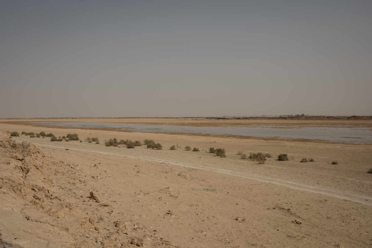
By Hélène Sallon 21 August 2022 (Le Monde) – From the top of the old tourist complex built on the shores of Lake Sawa, in the province of Al-Muthanna in southern Iraq, the desert stretches as far as the eye can see. The buildings have been abandoned since the 2003 US-British invasion. “In the past, […]

Monthly mean atmospheric methane abundance, 1983-2021. The globally-averaged, monthly mean atmospheric methane abundance is determined from marine surface sites. Values for 2021 are preliminary. Graphic: NOAA Global Monitoring Laboratory

Increase in atmospheric methane set another record during 2021 – Carbon dioxide levels also record a big jump – “The evidence is consistent, alarming, and undeniable”

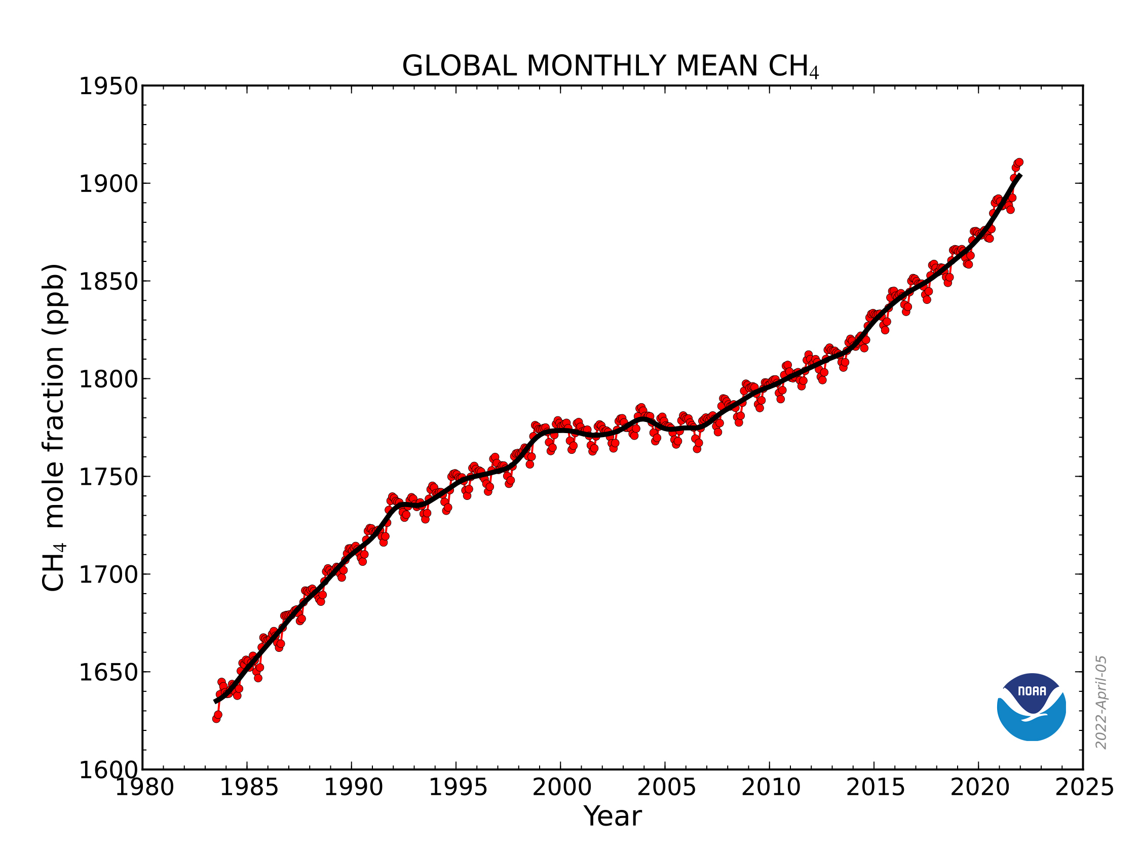
7 April 2022 (NOAA) – For the second year in a row, NOAA scientists observed a record annual increase in atmospheric levels of methane, a powerful, heat-trapping greenhouse gas that’s the second biggest contributor to human-caused global warming after carbon dioxide. NOAA’s preliminary analysis showed the annual increase in atmospheric methane during 2021 was 17 […]

Deer photographed by a remote camera on 11 August 2020 in a forest destroyed by climate change in North Carolina. Sea level rise and saltwater intrusion are killing trees en masse, causing ghost forests. Photo: Emily Ury

Sea level rise is killing trees along the Atlantic coast, creating “ghost forests” that are visible from space

By Emily Ury 6 April 2021 (The Conversation) – Trekking out to my research sites near North Carolina’s Alligator River National Wildlife Refuge, I slog through knee-deep water on a section of trail that is completely submerged. Permanent flooding has become commonplace on this low-lying peninsula, nestled behind North Carolina’s Outer Banks. The trees growing in […]

The Arkup luxury floating villa docked at Star Island in Miami Beach, Florida, on 5 February 2021. It costs $5.5 million and adjusts to the rising sea levels that are threatening Florida. The house, covered with a roof of solar panels, remains stable thanks to four hydraulic pillars that fix it to an underwater bed. Photo: Chandan Khanna / AFP

Miami mayor announces plan to spend billions tackling sea-level rise

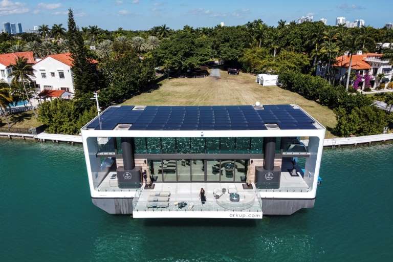
27 February 2021 (AFP) – The U.S. city of Miami is to invest billions of dollars to tackle its vulnerability to rising sea levels, a reality that already affects the daily lives of residents used to constant flooding. Miami-Dade County Mayor Daniella Levine-Cava said Friday she will protect communities hardest hit by rising sea levels, […]

Caribou and geese at Teshekpuk Lake in North Slope Borough, Alaska in 2019. The Trump administration, in its final days, decided to open millions more acres of land in the Alaskan Arctic to oil and gas drilling, including the wetlands around Teshekpuk Lake, which are a crucial breeding area for migratory birds and calving grounds for roaming caribou. Photo: Bonnie Jo Mount / The Washington Post

Trump administration opens millions more acres of Alaska to drilling – “A last-minute and irresponsible effort to open an enormous amount of land in a sensitive area”

By Dino Grandoni 5 January 2021 (The Washington Post) – The Trump administration, in its final days, decided to open millions more acres of land in the Alaskan Arctic to oil and gas drilling. The decision from the Bureau of Land Management on Monday, finalized just two weeks before President Trump is set to leave office, will […]

Aerial view of the Deepwater Horizon oil rig burning after an explosion in the Gulf of Mexico, off the southeast tip of Louisiana, 21 April 2010. Ten years after an oil rig explosion killed 11 workers and unleashed an environmental nightmare in the Gulf of Mexico, companies are drilling into deeper and deeper waters where the payoffs can be huge but the risks are greater than ever. Photo: Gerald Herbert / AP Photo

10 years after BP spill: Oil drilled deeper; rules relaxed – “I’m concerned that in the industry, the lessons aren’t fully learned — that we’re tending to backslide”

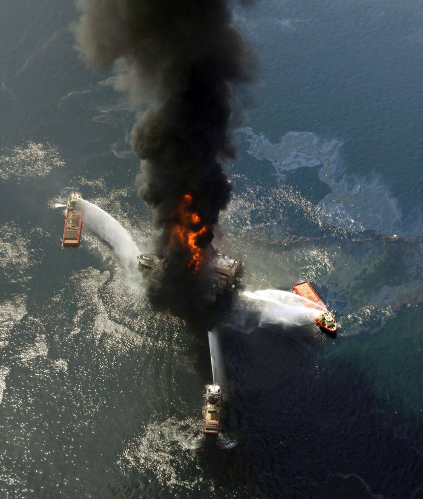
By Kevin Mcgill and Matthew Brown 18 April 2020 NEW ORLEANS (AP) – Ten years after an oil rig explosion killed 11 workers and unleashed an environmental nightmare in the Gulf of Mexico, companies are drilling into deeper and deeper waters, where the payoffs can be huge but the risks are greater than ever. Industry leaders and […]

Indonesians wade through flood water on a street in Jakarta, Indonesia, Tuesday, 25 February 2020. Overnight rains caused rivers to burst their banks in greater Jakarta sending muddy water into residential and commercial areas, inundating thousands of homes and paralyzing parts of the city's transport networks, officials said. Photo: Tatan Syuflana / AP Photo

Thousands caught in floods in Indonesia’s sinking capital – More rain expected for the next two weeks – Disaster agency head resigns

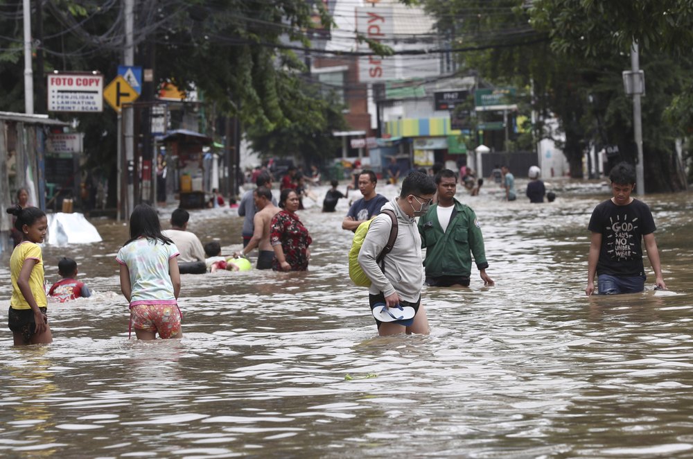
By Niniek Karmini 25 February 2020 JAKARTA, Indonesia (AP) – Floods that have crippled much of Indonesia’s capital worsened Tuesday, inundating thousands of homes and buildings, including the presidential palace, and paralyzing transport networks, officials and witnesses said. Overnight rains caused more rivers to burst their banks in greater Jakarta starting Sunday, sending muddy water […]

Spatial cumulative extents of the Deepwater Horizon (DWH) oil spill. (A) Cumulative NESDIS anomaly daily composites integrated from 20 April 2010 to 21 July 2010. Daily fishing closures are marked with gray lines; the cumulative fishing closure area is marked with a thick dashed yellow line. The black star represents the location of the DWH blowout. (B) Cumulative value of daily average oil concentrations (ppb), integrated across the same time span as (A) and across water depths. Vertical depth layers are 0 to 1 m, 1 to 20 m, and in 20-m increments down to 2500 m. Sediment and water samples with higher-than-background concentration are marked in bright green and dark blue circles, respectively. Red crosses in (B) represent approximate locations of DWH-related oil detections reported in previous studies. Daily fishery closures are marked with black polygons; the cumulative fishery closure area is marked with a dashed thick polygon. AB, Apalachee Bay; DP, Deep Plume; EFS, East Florida Shelf; FK, Florida Keys; LC, Loop Current System; TXS, Texas Shores; WFS, West Florida Shelf. (C) Categorization of the modeled oil spill are as follows: (i) nontoxic, PAH concentrations above background level and smaller than 0.5 and 1 ppb at the surface (depth, 0 to 1 m) and in the water column (depth, >1 m), respectively; (ii) toxic-to-biota and invisible, PAH concentrations 0.5 to 17 ppb at the surface and above 1 ppb in the water column; and (iii) toxic and visible, PAH concentrations above 17 ppb. In (C), categories were computed according to maximal concentrations across time. (D) Duration of toxic concentrations across the domain. (E) LC50 of 12 experiments examining the photoinduced toxicity to blue crab (31), fiddler crab (33), mahi mahi (29, 30), red drum (32), and speckled sea trout (32) (for more details, see table S2). (F) The spatial extent of the toxic concentrations from (E); color codes in (F) are according to bar colors in (E), representing concentrations exceeding LC50. In (F), toxic PAH of 0.5 ppb was concentrations were considered for surface waters only (depth, 0 to 1 m). Graphic: Berenshtein, et al., 2020 / Science Advances

The toxic reach of the Deepwater Horizon oil spill was much larger and deadlier than previous estimates – “Large areas of the Gulf of Mexico were exposed to invisible and toxic oil that extended beyond the boundaries of the satellite footprint and the fishery closures”

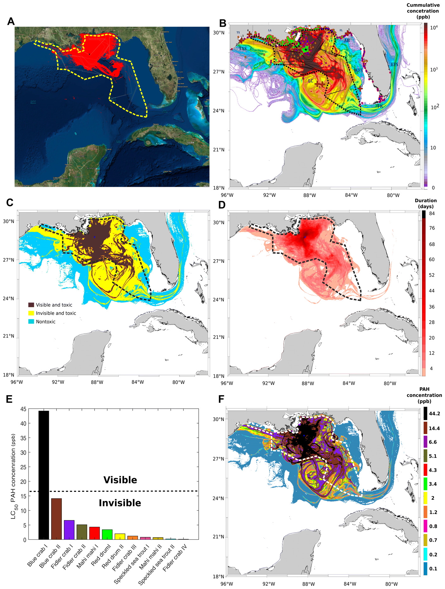
By Darryl Fears 12 February 2020 (The Washington Post) – The spread of oil from the Deepwater Horizon disaster in the Gulf of Mexico was far worse than previously believed, new research has found. As the worst offshore oil spill in U.S. history approaches its 10th anniversary in April, a study by two University of Miami researchers […]

Geese landing in the restored wetland on Viola Farm. Matt and Marilyn Spong own a corn-and-soybean farm, located on the Delmarva. Viola Farms has been in Marilyn Spong’s family for well over 150 years. About 15 years ago they started the process of restoring a wetland habitat on their property. Photo: Kayt Jonsson / USFWS / Flickr

America’s wetlands: vital, ignored, and now defined away by the Trump administration

By Geena Reed 27 January 2020 (UCS) – Last week, the Trump administration finalized its rollback of the expanded definition of the waters of the United States. Now fewer water bodies, including wetlands and ephemeral streams, will be protected under the Clean Water Act. The quality of more than half of the country’s wetlands and 18 percent of its […]

Social media & sharing icons powered by UltimatelySocial