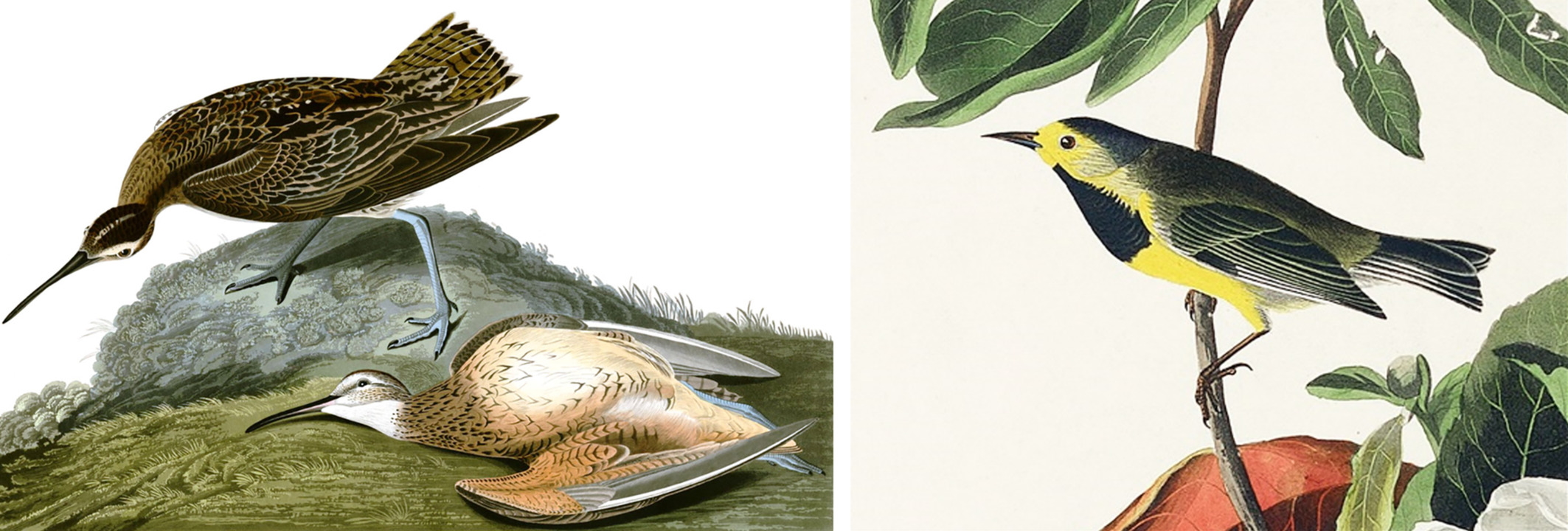
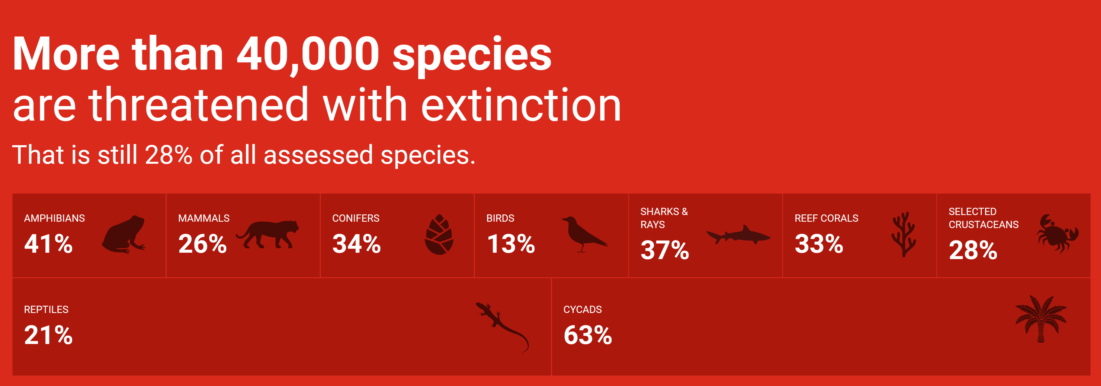
Banner from the WWF web site on 29 December 2021 showing more than 40,000 species are threatened with extinction, comprising 28 percent of all assessed species. Graphic: WWF

WWF: Looming mass extinction could be biggest since the dinosaurs – “One million species could go extinct within the next decade, which would be the largest mass extinction event since the end of the dinosaur age”

29 December 2021 (DW) – Ever-growing environmental threats are pushing many animals and plants to the brink of extinction — the scale of which hasn’t been seen since dinosaurs died out, the German branch of the World Wildlife Fund (WWF) said on Wednesday. The stark warnings came as WWF Germany released its “Winners and Losers of 2021,” an annual […]

A dead crane, foreground, at the Hula Nature Reserve in northern Israel in December 2021. A bird flu outbreak in northern Israel killed at least 5,200 migratory cranes and forced farmers to slaughter hundreds of thousands of chickens as authorities tried to contain what they say is the deadliest wildlife disaster in the nation’s history. Photo: Ayal Margolin / JINIPIX / Associated Press

Bird flu in Israel kills 5,200 cranes and forces slaughter of half-million chickens – Environment minister calls outbreak “the most serious damage to wildlife in the history of the country”

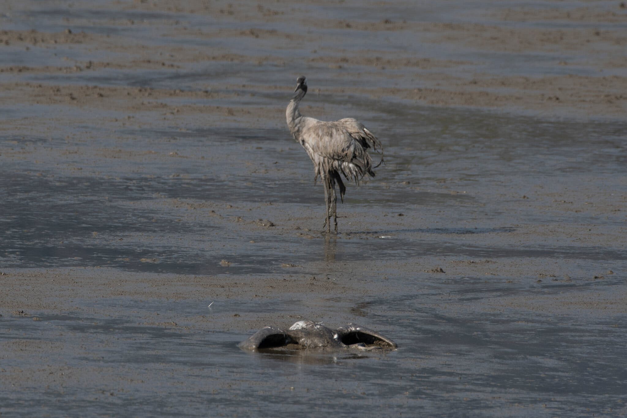
By Isabel Kershner 29 December 2021 JERUSALEM (The New York Times) – Israel is acting to contain a severe outbreak of avian flu that has already led to mass culling of infected poultry and has caused the deaths of about 5,000 migratory cranes in a popular nature reserve in the north of the country. The minister […]

Satellite view of Lake Tuz in Turkey acquired on 23 October 2021. Lake Tuz is Turkey's second-largest lake and home to several bird species. During the summer of 2021, the lake completely dried up causing the death of thousands of flamingos and other bird species that inhabit the lake. Experts attribute the extreme drought in eastern Turkey to climate change. Photo: European Union / Copernicus Sentinel-2 imagery

Haunting satellite imagery shows Turkey’s second-largest lake has dried up

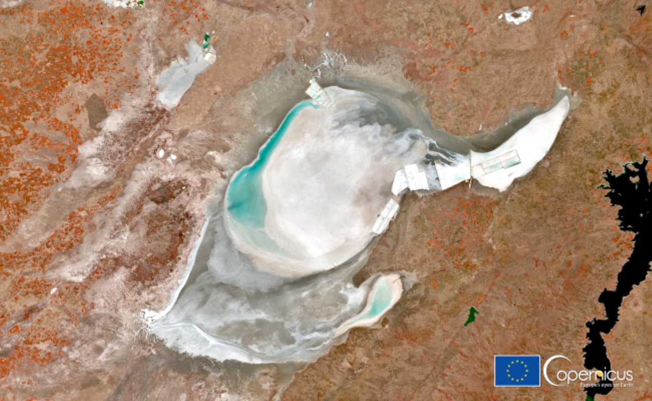
By Molly Taft 2 November 2021 (Gizmodo) – A new satellite image of Turkey’s Lake Tuz is gorgeous—and, if you know more about what it’s portraying, worrying. The stunning capture from the European Space Agency’s Sentinel-2 satellite shows Turkey’s second-largest lake has completely dried up this year, exposing a haunting expanse of salt. While Lake Tuz, one of the world’s largest saltwater lakes, […]

Aerial view of the Deepwater Horizon oil rig burning after an explosion in the Gulf of Mexico, off the southeast tip of Louisiana, 21 April 2010. Ten years after an oil rig explosion killed 11 workers and unleashed an environmental nightmare in the Gulf of Mexico, companies are drilling into deeper and deeper waters where the payoffs can be huge but the risks are greater than ever. Photo: Gerald Herbert / AP Photo

10 years after BP spill: Oil drilled deeper; rules relaxed – “I’m concerned that in the industry, the lessons aren’t fully learned — that we’re tending to backslide”

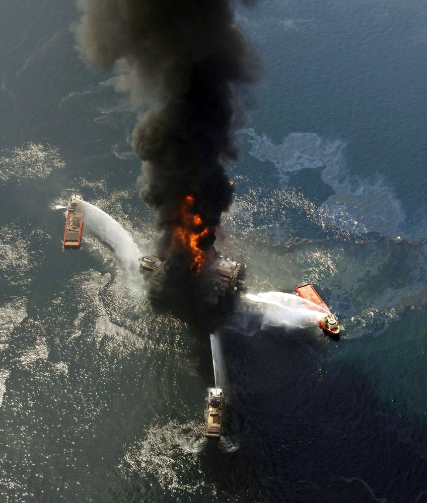
By Kevin Mcgill and Matthew Brown 18 April 2020 NEW ORLEANS (AP) – Ten years after an oil rig explosion killed 11 workers and unleashed an environmental nightmare in the Gulf of Mexico, companies are drilling into deeper and deeper waters, where the payoffs can be huge but the risks are greater than ever. Industry leaders and […]

Spatial cumulative extents of the Deepwater Horizon (DWH) oil spill. (A) Cumulative NESDIS anomaly daily composites integrated from 20 April 2010 to 21 July 2010. Daily fishing closures are marked with gray lines; the cumulative fishing closure area is marked with a thick dashed yellow line. The black star represents the location of the DWH blowout. (B) Cumulative value of daily average oil concentrations (ppb), integrated across the same time span as (A) and across water depths. Vertical depth layers are 0 to 1 m, 1 to 20 m, and in 20-m increments down to 2500 m. Sediment and water samples with higher-than-background concentration are marked in bright green and dark blue circles, respectively. Red crosses in (B) represent approximate locations of DWH-related oil detections reported in previous studies. Daily fishery closures are marked with black polygons; the cumulative fishery closure area is marked with a dashed thick polygon. AB, Apalachee Bay; DP, Deep Plume; EFS, East Florida Shelf; FK, Florida Keys; LC, Loop Current System; TXS, Texas Shores; WFS, West Florida Shelf. (C) Categorization of the modeled oil spill are as follows: (i) nontoxic, PAH concentrations above background level and smaller than 0.5 and 1 ppb at the surface (depth, 0 to 1 m) and in the water column (depth, >1 m), respectively; (ii) toxic-to-biota and invisible, PAH concentrations 0.5 to 17 ppb at the surface and above 1 ppb in the water column; and (iii) toxic and visible, PAH concentrations above 17 ppb. In (C), categories were computed according to maximal concentrations across time. (D) Duration of toxic concentrations across the domain. (E) LC50 of 12 experiments examining the photoinduced toxicity to blue crab (31), fiddler crab (33), mahi mahi (29, 30), red drum (32), and speckled sea trout (32) (for more details, see table S2). (F) The spatial extent of the toxic concentrations from (E); color codes in (F) are according to bar colors in (E), representing concentrations exceeding LC50. In (F), toxic PAH of 0.5 ppb was concentrations were considered for surface waters only (depth, 0 to 1 m). Graphic: Berenshtein, et al., 2020 / Science Advances

The toxic reach of the Deepwater Horizon oil spill was much larger and deadlier than previous estimates – “Large areas of the Gulf of Mexico were exposed to invisible and toxic oil that extended beyond the boundaries of the satellite footprint and the fishery closures”

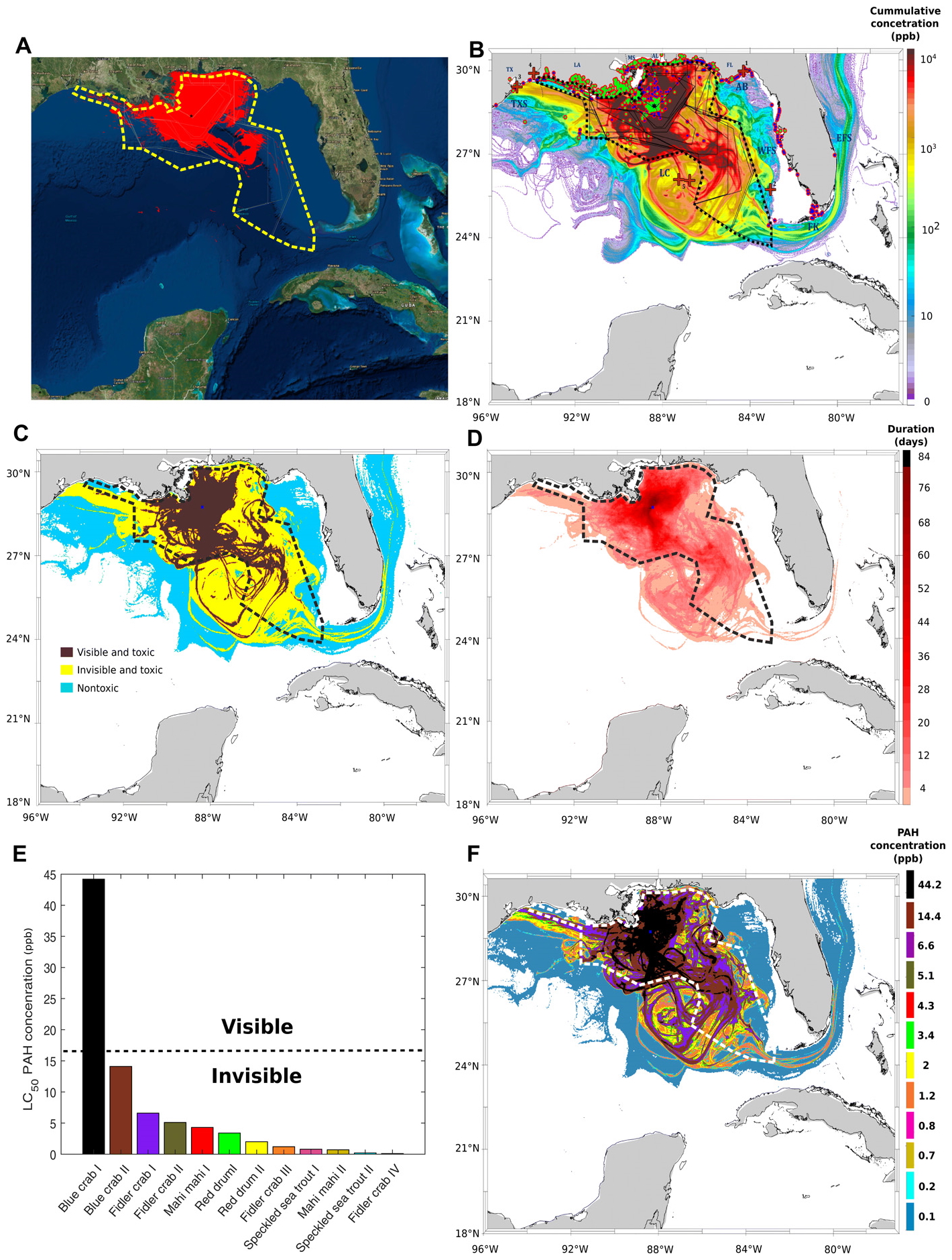
By Darryl Fears 12 February 2020 (The Washington Post) – The spread of oil from the Deepwater Horizon disaster in the Gulf of Mexico was far worse than previously believed, new research has found. As the worst offshore oil spill in U.S. history approaches its 10th anniversary in April, a study by two University of Miami researchers […]

Geese landing in the restored wetland on Viola Farm. Matt and Marilyn Spong own a corn-and-soybean farm, located on the Delmarva. Viola Farms has been in Marilyn Spong’s family for well over 150 years. About 15 years ago they started the process of restoring a wetland habitat on their property. Photo: Kayt Jonsson / USFWS / Flickr

America’s wetlands: vital, ignored, and now defined away by the Trump administration

By Geena Reed 27 January 2020 (UCS) – Last week, the Trump administration finalized its rollback of the expanded definition of the waters of the United States. Now fewer water bodies, including wetlands and ephemeral streams, will be protected under the Clean Water Act. The quality of more than half of the country’s wetlands and 18 percent of its […]

On 1 January 2016 and 2 January 2016, 6,540 common murre carcasses were found washed ashore near Whitter, Alaska, translating into about 8,000 bodies per mile of shoreline — one of the highest beaching rates recorded during the mass mortality event. Photo: David B. Irons

Huge “hot blob” in Pacific Ocean caused mass starvation in largest seabird die-off – “The magnitude and scale of this failure has no precedent”

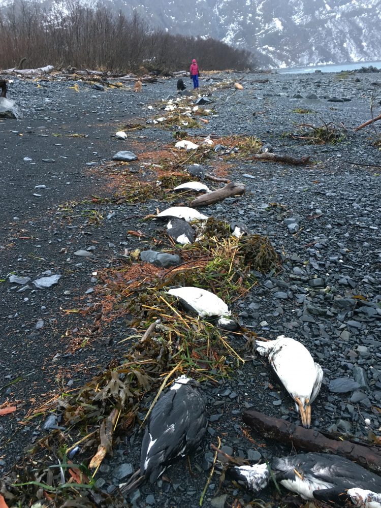
By Michelle Ma 15 January 2020 (UW News) – The common murre is a self-sufficient, resilient bird. Though the seabird must eat about half of its body weight in prey each day, common murres are experts at catching the small “forage fish” they need to survive. Herring, sardines, anchovies and even juvenile salmon are no […]

A boy cradles the body of dead endangered Brush-tailed rock-wallaby, found near a muddy puddle of water after a bushfire in Gosford, New South Wales, Australia, on 6 January 2020. The boy asked his father, Tim Faulkner, “They’re all dying aren’t they Dad?” Faulkner told him it was his job to save the world. Photo: Tim Faulkner / Facebook

Estimated number of animals killed in Australia bushfires rises to more than one billion – “Events like this may well hasten the extinction process for a range of species”

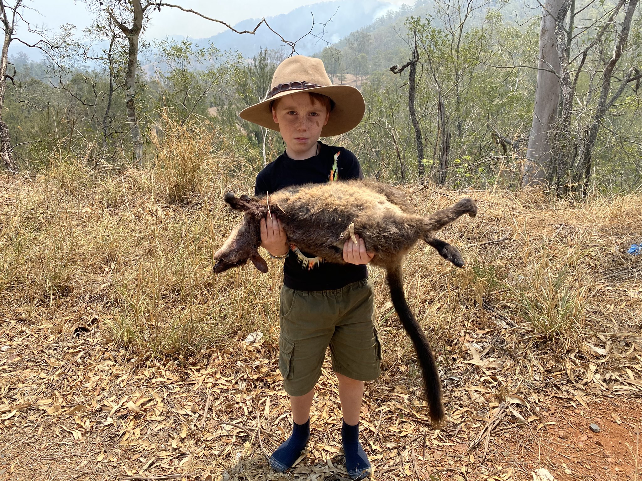
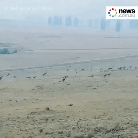
8 January 2020 (University of Sydney) – Professor Chris Dickman has revised his estimate of the number of animals killed in bushfires in NSW to more than 800 million animals, with a national impact of more than one billion animals. Several weeks ago Professor Dickman, from the University of Sydney’s Faculty of Science, estimated that 480 […]

Kangaroos flee bushfires in Monaro, New South Wales, 30 December 2019. Photo: Mitchell Lyons / 7 News / News.com.au

Nearly 500 million animals killed in Australia bushfires since September 2019 – 30 percent of koalas incinerated by “unfightable” fires in New South Wales – Thousands of fire-injured sheep shot on Kangaroo Island

By Marnie O’Neill 1 January 2020 (News.com.au) – There are concerns that entire species of plants and animals may have been wiped out by bushfires following estimations that 480 million animals may die as a result of the crisis. Ecologists from the University of Sydney estimate almost half a billion mammals, birds and reptiles may […]

Study skins of the extinct Lana’i and Kaua’i ‘akiaola. Photo: Paul Sweet / AMNH

All of the species declared extinct in the 2010-2019 decade – “The trends that connect these 160 extinctions are true of the biodiversity crisis more generally”

By Ryan F. Mandelbaum 16 December 19 (Gizmodo) – Lonesome George, the last of the Pinta Island tortoises, died in 2012. George’s story is the perfect extinction story. It features a charismatic character with a recognizable face, an obvious villain, and the tireless efforts of naturalists. The population of the Pinta Island tortoise species was […]

Social media & sharing icons powered by UltimatelySocial