More than 100 Arctic wildfires burn in worst-ever fire season – Smoke plumes from huge blazes in Greenland, Siberia, and Alaska visible from space – “These are some of the biggest fires on the planet, with a few appearing to be larger than 100,000 hectares”
By Edward Helmore
26 July 2019
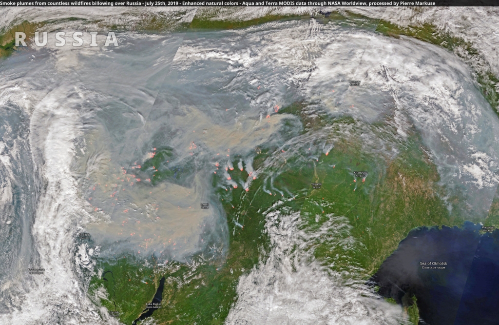
(The Guardian) – The Arctic is suffering its worst wildfire season on record, with huge blazes in Greenland, Siberia, and Alaska producing plumes of smoke that can be seen from space.
The Arctic region has recorded its hottest June ever. Since the start of that month, more than 100 wildfires have burned in the Arctic circle. In Russia, 11 of 49 regions are experiencing wildfires.
The World Meteorological Organization (WMO), the United Nations’ weather and climate monitoring service, has called the Arctic fires “unprecedented”.
The largest blazes, believed to have been caused by lightning, are located in Irkutsk, Krasnoyarsk, and Buryatia. Winds carrying smoke have caused air quality to plummet in Novosibirsk, the largest city in Siberia.
In Greenland, the multi-day Sisimiut blaze, first detected on 10 July 2019, came during an unusually warm and dry stretch in which melting on the vast Greenland ice sheet commenced a month earlier than usual.
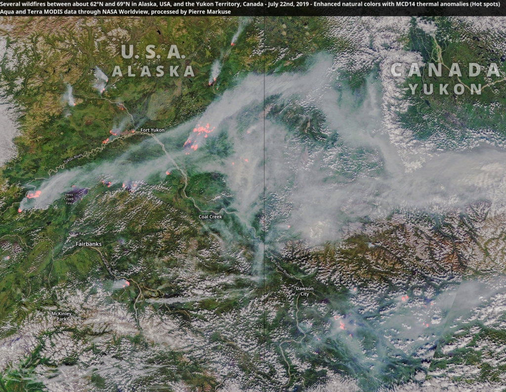
In Alaska, as many as 400 fires have been reported. The climatologist Rick Thomas estimated the total area burned in the state this season as of Wednesday morning at 2.06 million acres. […]
Thomas Smith, an environmental geographer at the London School of Economics, told USA Today fires of such magnitude have not been seen in the 16-year satellite record. […]
“These are some of the biggest fires on the planet, with a few appearing to be larger than 100,000 hectares,” Smith said.
“The amount of [carbon dioxide] emitted from Arctic circle fires in June 2019 is larger than all of the CO2 released from Arctic circle fires in the same month from 2010 through to 2018 put together.” [more]
‘Unprecedented’: more than 100 Arctic wildfires burn in worst ever season
Unprecedented wildfires in the Arctic
12 July 2019 (WMO) – Unusually hot and dry conditions in parts of the northern hemisphere have been conducive to fires raging from the Mediterranean to – in particular – the Arctic. Climate change, with rising temperatures and shifts in precipitation patterns, is amplifying the risk of wildfires and prolonging the season.
WMO’s Global Atmosphere Watch Programme has released a short animation which highlights the risks and explains how advances in satellite technology make it possible to detect and monitor fire dangers. Improving forecasting systems is important for predictions and warnings around fire danger and related air pollution hazards.
In addition to the direct threat from burning, wildfires also release harmful pollutants including particulate matter and toxic gases such as carbon monoxide, nitrogen oxides, and non-methane organic compounds into the atmosphere.
Particles and gases from burning biomass can be carried over long distances, affecting air quality in regions far away.
Heatwaves fuel fires
Since the start of June, the Copernicus Atmosphere Monitoring Service (CAMS) has tracked over 100 intense and long-lived wildfires in the Arctic Circle. In June alone, these fires emitted 50 megatonnes of carbon dioxide into the atmosphere, which is equivalent to Sweden’s total annual emissions. This is more than was released by Arctic fires in the same month between 2010 and 2018 combined.
Although wildfires are common in the northern hemisphere between May and October, the latitude and intensity of these fires, as well as the length of time that they have been burning for, has been particularly unusual, according to CAMS Senior Scientist and wildfires expert, Mark Parrington.
The ongoing Arctic fires have been most severe in Alaska and Siberia, where some have been large enough to cover almost 100 000 football pitches, or the whole of Lanzarote. In Alberta, Canada, one fire is estimated to have been bigger than 300 000 pitches. In Alaska alone, CAMS has registered almost 400 wildfires this year, with new ones igniting every day.
The average June temperature in the parts of Siberia where wildfires are raging, was almost ten degrees higher than the 1981–2010 average.
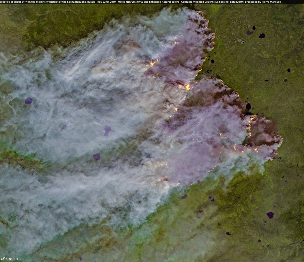
Temperatures in Alaska hit record highs of up to 90°F (32°C) in Alaska on 4 July, fuelling fires in the state, including along the Yukon River along the Arctic Circle. In Canada, smoke from massive wildfires near Ontario are producing large amounts of particulate matter, affecting air quality. The heatwave in Europe at the end of June also triggered wildfires in a number of countries, including Germany, Greece and Spain.
CAMS, which is implemented by the European Centre for Medium-Range Weather Forecasts (ECMWF) on behalf of the EU, incorporates observations of wildfires from the MODIS instruments on NASA’s Terra and Aqua satellites into its Global Fire Assimilation System (GFAS) to monitor the fires and estimate the emission of pollutants from them. It assimilates fire radiative power observations from satellite-based sensors to produce daily estimates of biomass burning emissions which are part of the extensive measurements performed by many stations of the Global Atmosphere Watch (GAW) Programme. These measurements are essential for forecasts, research on atmospheric composition and to develop warning systems.
Climate change
The northern part of the world is warming faster than the planet as a whole. That heat is drying out forests and making them more susceptible to burn. A recent study found Earth’s boreal forests are now burning at a rate unseen in at least 10,000 years.
Wildfires also release carbon dioxide into the atmosphere, contributing to global warming. For instance, the 2014 megafires in Canada scorched more than 7 million acres of forest, releasing more than 103 million tonnes of carbon into the atmosphere – half as much as all the plants and trees in Canada typically absorb in an entire year, according to a study by NASA.
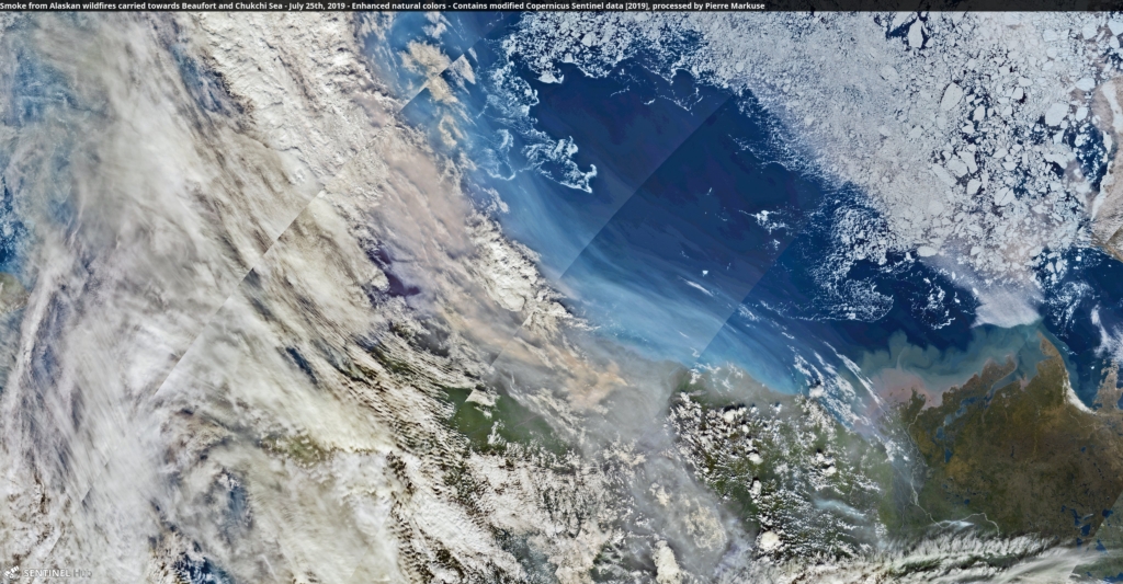
The pristine Arctic environment is particularly sensitive/fragile and warming faster than most other regions. Particles of smoke can land on snow and ice, causing the ice to absorb sunlight that it would otherwise reflect, and thereby accelerating the warming in the Arctic. Fires in the Arctic also increase the risk of further permafrost thawing that releases methane, which is also a greenhouse gas.
In view of the risks, WMO has initiated a Vegetation Fire and Smoke Pollution Warning and Advisory System to develop, implement and harmonize fire forecasting across the globe, providing a better picture of fires and related impacts and hazards everywhere. The Southeast Asia Regional Centre, operated by the meteorological service of Singapore, is already producing forecasts.
