Map showing global climate risk as an Aggregated Damage Ratio, projected to the year 2050. Graphic: XDI

By Pandora Dewan
24 February 2023

(Newsweek) – By 2100, Florida could see sea levels rise by up to 6 feet, with over 900,000 properties at risk of being underwater.

“By 2050, Florida sea levels, like much of the US, are headed for a 1-foot rise on average (above 2020 levels),” William Sweet, an Oceanographer for the National Oceanic and Atmospheric Administration, told Newsweek. “By 2100, Florida is likely to experience at least 2 feet of rise (above 2020 levels) due to emissions to date, but that rise amount could be much higher if emissions and resulting ocean and atmospheric heating continues to increase. Up to 6 feet or so of rise by 2100 cannot be ruled out under a high emissions/heating scenario.”

From these projections, the real estate company Zillow predicts that one in eight Florida properties could be underwater by 2100.

A report by the climate risk specialists, XDI, on February 20 found that, outside of China, Florida is the most at-risk state/province in the world for economic damage caused by climate change. This largely comes down to the state’s geography: Florida has over 1,200 miles of coastline, and most of its 18 million residents live within 60 miles of the Atlantic Ocean or the Gulf of Mexico, according to a report by the Florida Energy and Climate Commission.

“Sea Level Rise is the most critical [threat to the state],” Harold Wanless, a geography professor at the University of Miami, told Newsweek. “South Florida has already had over a 1-foot rise in the past century…and sea level is presently rising here at a rate of nearly 3 feet per century and accelerating.

“Peninsular Florida is also projected to have two more months of temperatures above 90 degrees by mid-century. Plus, major hurricanes are increasing in frequency. This latter, combined with sea level rise will make for significantly increased devastation by storm surges, wind and rain damage.”

Sea level rise is a driving hazard for many states. The US Fourth National Climate Assessment found that sea level rise rates along the Mid-Atlantic Coast were three to four times higher than the global average rate. In the Mid-West, the highest ranking states are those that have both escalating risk from both flood and wildfire. The US has experienced 332 weather and climate related disasters since 1980 where overall damages reached or exceeded US$1 billion with the frequency of these events increasing in recent years. In the last five years, there’s been an average of 18 of these events per year. Florida, on the coast of the Gulf of Mexico, is the fourth largest state economy in the US, with gross domestic product of over a trillion US dollars. Florida is exposed to a number of climate-exacerbated hazards which are already manifesting, including increased number of extreme heat days, increased risk of wildfire, inland flooding and coastal inundation. The analysis in this ranking does not include additional climate change impacts expected in both Florida and Louisiana, such as escalating human health risk from mosquito-borne viruses. Louisiana is also on the Gulf coast and its major cities are in or beside the Mississippi River Delta. These cities and the coastline have already suffered the impacts of intense rainfall and flooding events, sea level rise and major hurricanes like Rita and Katrina. The analysis confirms the results of California’s Fourth Climate Change Assessment which estimated the state would experience US$113 billion in annual direct economic impact from climate change by 2050 without adaptation measures. In terms of escalation of damage, the US states with the highest percentage increase in Damage Ratio are Massachusetts, Alaska, Rhode Island, South Carolina, Hawaii and Connecticut, all of which experience a more than two-fold increase between 1990 and 2050. Graphic: XDI

The effects of climate change are already being felt across the peninsula, and they are only expected to get worse. “With our sea level rise to date, low-lying coastal areas are increasingly frequently flooding by even the smaller king spring tides and minor wind surge events,” Wanless said. “As a result, salt water in the streets is damaging vehicles, there is increased saltwater intrusion into our groundwater, inundated septic tanks are leaking out fecal pollution into the surface and ground waters, heavy rainfall drains away much more slowly, and ground floors and parking garages are prone to frequent flooding.”

The economic implications of this will affect people throughout the state. “As we could well have a further 2 to 3 feet or sea level rise by mid-century, there will come a point where 30 years mortgages are not available, required flood insurance will be either not available or not affordable, and hurricane/flood risk will have dramatically increased,” Wanless said.

Sweet said that understanding current and future flood risks is an important first step in helping people protect their families and their homes from the encroaching ocean. “Community responses thus far include building higher seawalls, elevating roadways, and fortifying infrastructure like stormwater system functionality.”

However, a true solution to this problem requires a global effort. “Reduced emissions with less ocean and atmospheric warming is the best solution to ensure less end-of-century sea level rise and flooding problems,” Sweet said. [more]

Florida’s Projected Sea Level Rise by 2100 Is Bad News for Sunshine State


Climate risk in Asia as an Aggregated Damage Ratio, projected to the year 2050. Asia dominates the list of provinces at risk by Aggregated Damage Ratio, with more than half (114) of the top 200 in 2050 in this region. More than a quarter (54) of these are in East Asia: 29 in China, 20 in Japan and 4 in South Korea. 36 of the top 200 are in Southeast Asia, notably Vietnam and Indonesia. South Asia has 24 of the top 200. After China, India has the highest number of states in the top 50 (9), with Punjab, Bihar, Uttar Pradesh and Assam ranking highest. Pakistan also has multiple provinces in the top 100, including Sindh province. Devastating flooding between June and August 2022 affected 30 per cent of the area of Pakistan and has partially or fully damaged more than 900,000 houses in Sindh province. East Asia and Southeast Asia see the greatest increase in Average Damage between 1990 and 2050, and China in particular has many provinces with the greatest overall Aggregated Damage Ratio. This increase and overall risk to the built environment in 2050 is driven predominately by sea level rise and secondarily by flooding risk” in the Asia section should read “by flooding and coastal inundation. The analysis highlights the vulnerability of major cities in East Asia and Southeast Asia including Jakarta, Beijing, Hồ Chí Minh City, and Taiwan. Graphic: XDI

XDI releases world-first comparison of every state’s physical climate risk

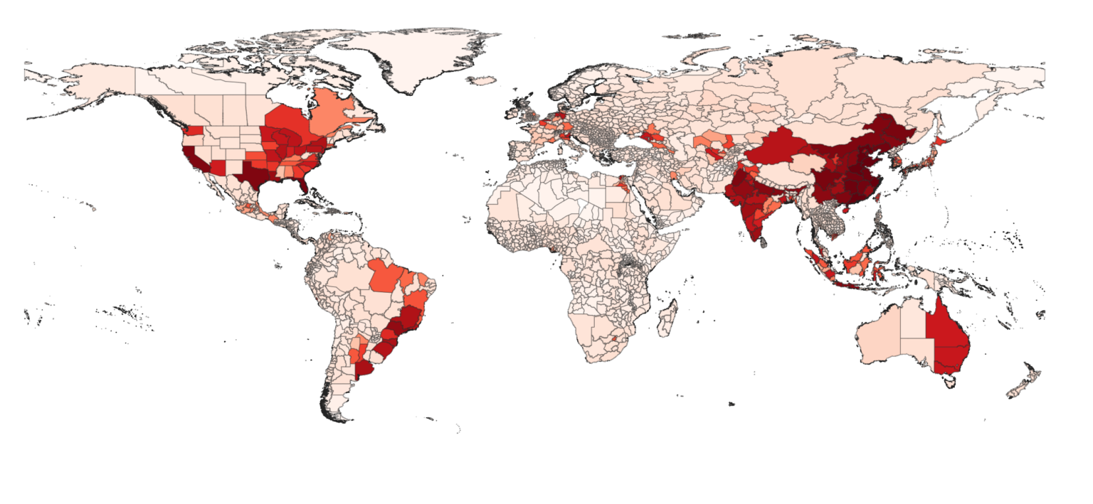
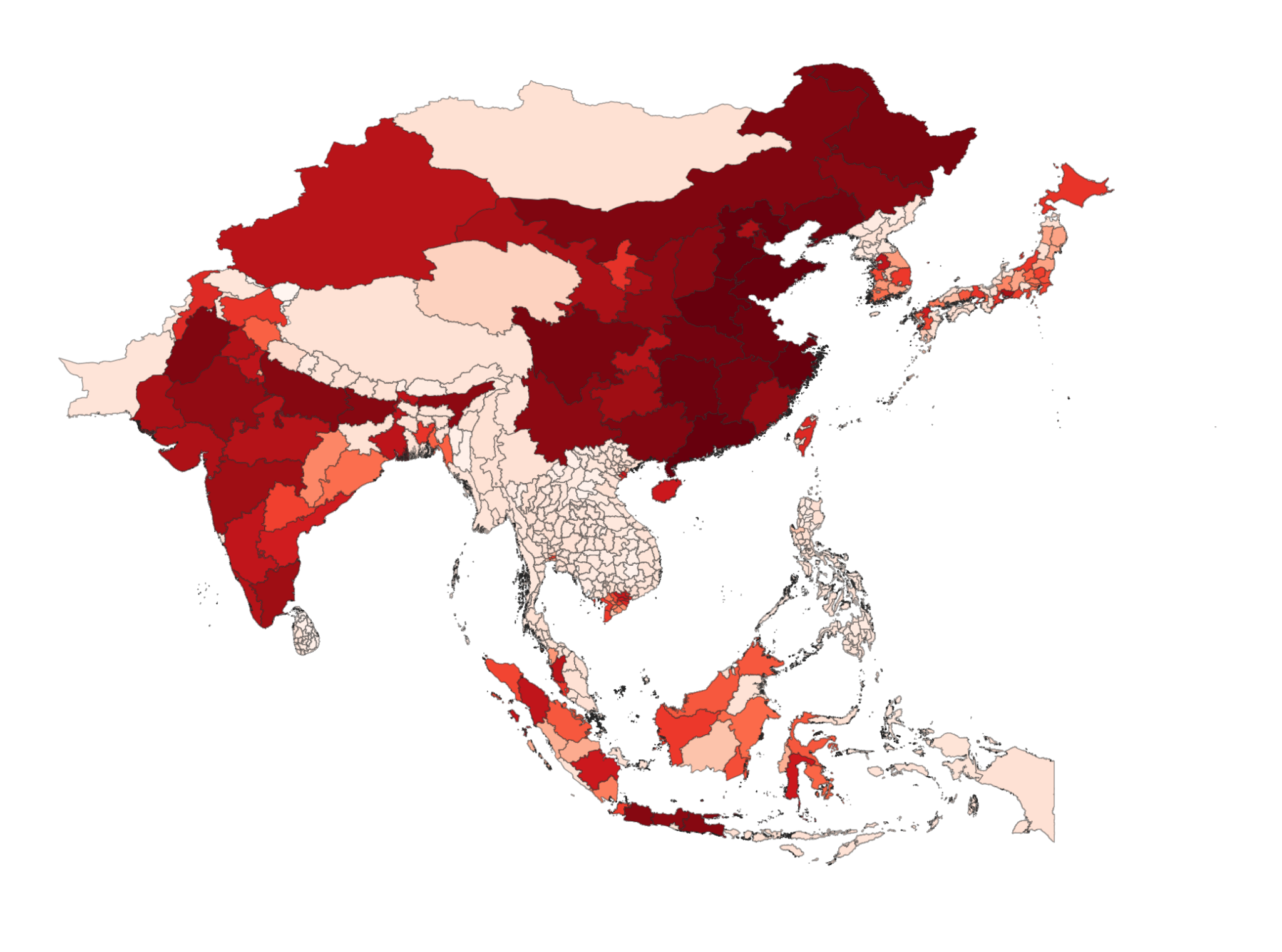
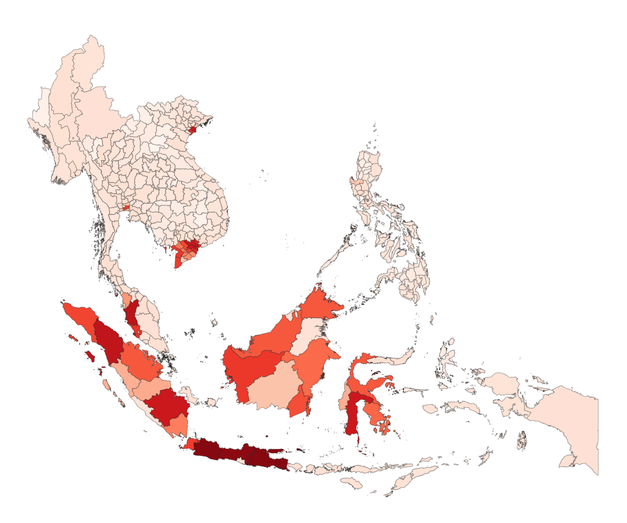
20 February 2023 (XDI) – The engine rooms of the global economy are among states and provinces most at risk from climate change and extreme weather according to a new ranking of the physical climate risk of every state, province and territory in the world released today by XDI (The Cross Dependency Initiative) – a world leader in physical climate risk analysis.

XDI’s Gross Domestic Climate Risk ranks over 2,600 jurisdictions around the world in 2050 according to modelled projections of damage to the built environment from extreme weather and climate change including from flooding, forest fires, and sea level rise. It also identifies which of these jurisdictions see the greatest escalation of modelled damage from 1990 to 2050.

The results show that globally-significant states and provinces in China and the United States will be hit hardest, along with major cities and centres of economic activity around the world.

“We’re releasing this analysis in response to demand from investors for data on sub-sovereign and regional risk,” said XDI CEO Rohan Hamden.

“This is the first time there has been a physical climate risk analysis focused exclusively on the built environment, comparing every state, province and territory in the world. Since extensive built infrastructure generally overlaps with high levels of economic activity and capital value it is imperative that the physical risk of climate change is appropriately understood and priced.” 

Gross Domestic Climate Risk ranking of 2,600+ territories, 1990-2100. This graph shows each of the provinces in the ranking, grouped by global region, plotted according to their changing Aggregated Damage Risk (x-axis) and Average Damage Risk (y-axis) over time normalised against the global average in 1990. The global picture shows physical climate risk to the built environment in East Asia and Southeast Asia escalating steeply after 2030 and leading the world in regional Average Damage Ratio reflecting the density of the built environment in river deltas and coastal areas of these regions. The low ranking of other provinces, particularly in places like Sub-Saharan Africa, largely reflects the lower extent of their built infrastructure. It should not be interpreted that these areas are at low risk from climate change and extreme weather. It is important to note that this analysis has not included social, environmental and economic impacts from effects such as water shortages, or impacts on agricultural production, biodiversity or human well-being. Graphic: XDI

The XDI Gross Domestic Climate Risk comparison of physical climate risk for 2050 found: 

  • Two of China’s largest sub-national economies – Jiangsu and Shandong – top the global ranking, in first and second place. Over half of the provinces in the global top 50 are in China.
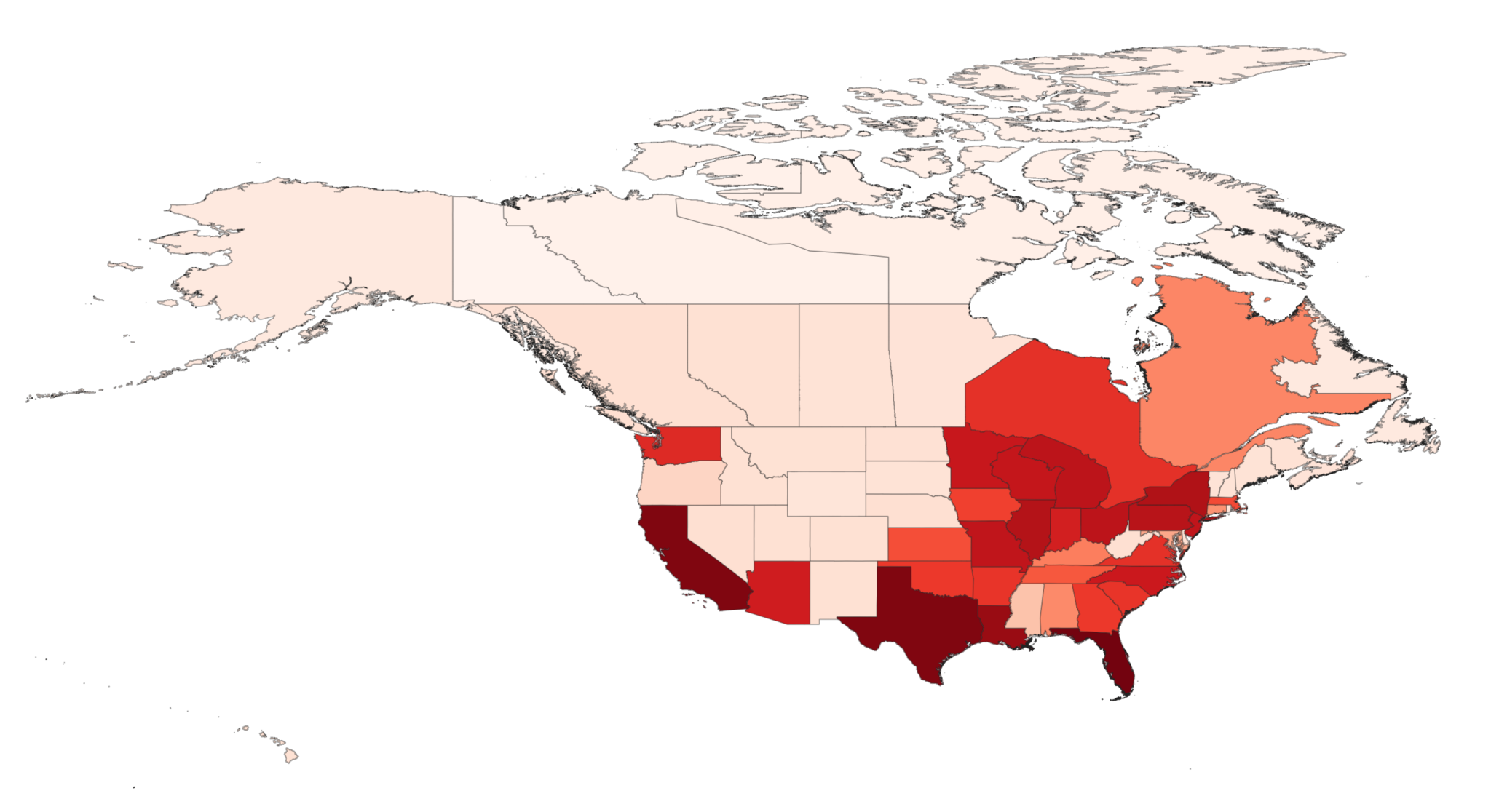
  • After China, the US has the most high-risk states with 18 states in the top 100. Florida is the highest-ranking US state, followed by California and Texas.
  • Together, China, India and the US make up over half the states and provinces in the top 100.
  • Other highly-developed and globally-significant economic hubs in the top 100 include Buenos Aires, São Paolo, Jakarta, Beijing, Hồ Chí Minh City, Taiwan, and Mumbai.
  • Australia, Belgium, Italy, Canada, and Germany also have states and provinces in the top 100.
  • South East Asia experiences the greatest escalation in damage from 1990 to 2050 anywhere in the world. 
  • Globally, most damage is caused by riverine and surface flooding or flooding combined with coastal inundation.

The financial cost of extreme weather and climate change is already being felt by many of the economies topping the XDI Gross Domestic Climate Risk ranking. In June 2022, extreme flooding in Guangdong, which ranks fourth in the analysis, caused an estimated 7.5 billion yuan in direct economic losses (over $1b USD). Hurricane Ian, which struck densely-populated parts of Florida in late September 2022, caused an estimated $67 billion in insured losses. Projections are for extreme weather events in regions like these to intensify in the coming years. Guangzhou, the capital of Guangdong, has been estimated to be ‘the most economically vulnerable city in the world’ to sea level rise by 2050.

“The findings from the XDI Gross Domestic Climate Risk ranking underscore the importance of pricing physical climate risk in financial markets, including bond markets, given the amount of capital investment represented by the assets at risk in the provinces identified, the vulnerability of global supply chains, and the need for climate resilience to inform investment,” said Mr Hamden.

“It is crucial for companies, governments and investors to understand the financial and economic implications of physical climate risk and weigh this risk in their decision-making before these costs escalate beyond financial tipping points,” he added.

Climate risk in Southeast Asia as an Aggregated Damage Ratio, projected to the year 2050. A focus on Aggregated Damage Ratio foregrounds large states and provinces with extensive built-up areas. Other parts of Southeast Asia rank among the highest in the world both for Average Damage Ratio and for the increase in damage from 1990 to 2050. There are a number of provinces that rank high for both Aggregated and Average Damage Ratios in 2050. Many of these are in Vietnam, including Ho Chi Minh City and Mekong Delta provinces like Long An, Vĩnh Long, Bến Tre, and Tiền Giang. The Mekong Delta is less than two metres above sea level on average, is home to 17 million people and produces most of Vietnam’s food. Other Southeast Asian provinces that rank high for both Aggregated and Average Damage Ratio include Jakarta, West Kalimantan (Kalimantan Barat) and Southern Sumatra (Sumatra Selatan). Southeast Asia experiences the greatest escalation in damage from 1990 to 2050. Among the places experiencing the highest percentage increases in damage to 2050 are islands in Mindanao in the Philippines, including the Sulu Archipelago, Tawi-Tawi and Camiguin. Graphic: XDI

About the Gross Domestic Climate Risk ranking

“This is the most sophisticated global analysis of physical climate risk to the built environment to date, offering a breadth and depth and granularity on a scale we haven’t seen before. Now – for the first time – the finance industry can directly compare Mumbai, New York and Berlin using a like-for-like methodology,” said Mr Hamden.

The XDI Gross Domestic Climate Risk ranking reflects physical risk to the built environment from eight climate change extreme weather hazards: riverine and surface flooding, coastal inundation, extreme heat, forest fire, soil movement (drought-related), extreme wind and freeze thaw.

The ranking is based on a data pool representing the built environment of the terrestrial world, with an asset level, bottom-up analysis using over 320 million data points. Global climate models, combined with local weather and environmental data and engineering archetypes calculate the likely damage to and failure of features of the built environment from hazards over time under the IPCC’s Representative Concentration Pathway (RCP) 8.5. 

The territories presented in the XDI Gross Domestic Climate Risk dataset are the first sub-national administrative jurisdiction for most countries. 

About XDI

The team behind XDI (The Cross Dependency Initiative) was established in 2006, making the group the world’s longest standing independent specialist in physical climate risk and adaptation analytics. XDI works with large national banks and companies in the UK, Asia, Europe and North America and is a leader in providing data for climate stress tests by financial regulators. XDI analysis informed a third of the stress tests conducted by banks regulated by the Bank of England and it has provided data for bank stress testing in Australia, Hong Kong, Singapore and New Zealand. 

XDI is part of The Climate Risk Group.

XDI releases world-first comparison of every state’s physical climate risk