Autumn could deliver the worst of California’s 2020 fire season – A scorching Labor Day weekend brought an all-time record heat and unprecedented fire spread, but fire risks climb in the fall
By Bob Henson
8 September 2020
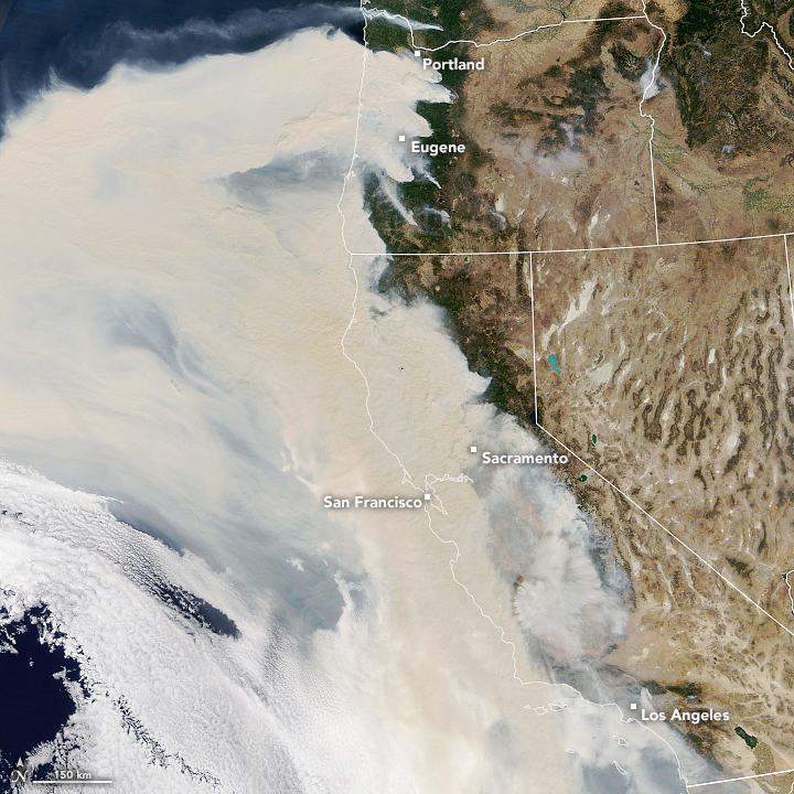
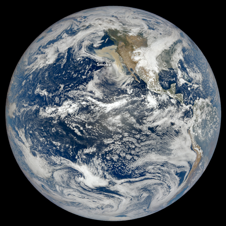
(Yale Climate Connections) – Temperatures reached ghastly levels in southern California and wildfire carved a path close to two of the state’s iconic national parks as a historic heat dome gripped the western United States during the traditional end-of-summer Labor Day weekend.
The heat had eased somewhat by Tuesday, 8 September 2020, but increasing winds were making the fire threat even worse across sun-baked landscapes from Washington to California.
“A potentially historic fire weather event is unfolding across the West, especially over the West Coast, during the next three days,” tweeted meteorologist Nick Nauslar (National Interagency Fire Center, or NIFC) on Monday.
Offshore wind season – the period in autumn when California’s most destructive fires tend to rage – is just getting under way. New research indicates that the state’s autumn fire season has gotten more dangerous in the past 30 years, and human-induced climate change may only accentuate this trend in decades to come. […]
Parts of Southern California endured the hottest day in their history on Saturday. Temperatures hit 121°F at Woodland Hills – the first official reading of at least 120°F ever recorded in Los Angeles, Santa Barbara, Ventura, or San Luis Obispo counties. Likewise, a scorching 121°F at Chino was an all-time high for the vast Inland Empire region of San Bernardino and Riverside counties.
As noted by The New York Times, Southern California Edison reported that electricity use soared more than 8% above the previous daily record on both Saturday and Sunday. […]
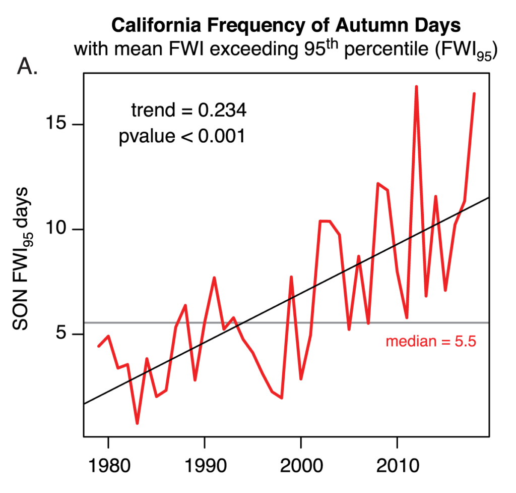
There’s now evidence that climate change is boosting the risk of extreme wildfire conditions in California autumns, according to an August study published in Environmental Research Letters and led by Michael Goss of Stanford University.
Examining weather data for the period from 1979 through 2018, Goss and colleagues found that the most extreme 5% of fire-weather days in autumn – as measured through an index based on temperature, humidity, winds, and precipitation – are now occurring more than twice as often as in the 1980s. In turn, these high-end days are closely associated with extreme autumn wildfires. The authors highlight two from November 2018: the Camp Fire, which decimated the town of Paradise in northern California, and the Woolsey Fire, which rampaged across parts of Los Angeles and Ventura counties. [more]
Autumn could deliver the worst of California’s 2020 fire season
Climate change is increasing the likelihood of extreme autumn wildfire conditions across California
ABSTRACT: California has experienced devastating autumn wildfires in recent years. These autumn wildfires have coincided with extreme fire weather conditions during periods of strong offshore winds coincident with unusually dry vegetation enabled by anomalously warm conditions and late onset of autumn precipitation. In this study, we quantify observed changes in the occurrence and magnitude of meteorological factors that enable extreme autumn wildfires in California, and use climate model simulations to ascertain whether these changes are attributable to human-caused climate change. We show that state-wide increases in autumn temperature (~1 °C) and decreases in autumn precipitation (~30%) over the past four decades have contributed to increases in aggregate fire weather indices (+20%). As a result, the observed frequency of autumn days with extreme (95th percentile) fire weather—which we show are preferentially associated with extreme autumn wildfires—has more than doubled in California since the early 1980s. We further find an increase in the climate model-estimated probability of these extreme autumn conditions since ~1950, including a long-term trend toward increased same-season co-occurrence of extreme fire weather conditions in northern and southern California. Our climate model analyses suggest that continued climate change will further amplify the number of days with extreme fire weather by the end of this century, though a pathway consistent with the UN Paris commitments would substantially curb that increase. Given the acute societal impacts of extreme autumn wildfires in recent years, our findings have critical relevance for ongoing efforts to manage wildfire risks in California and other regions.
Climate change is increasing the likelihood of extreme autumn wildfire conditions across California