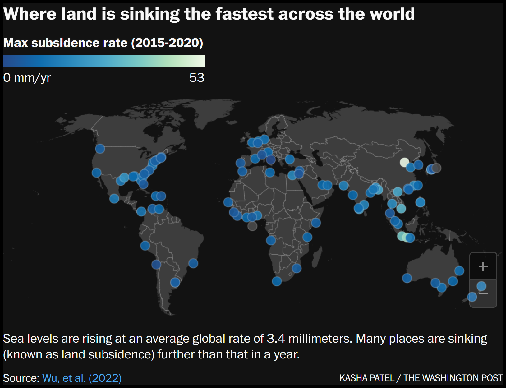
Land around the U.S. is sinking. Here are some of the fastest areas.
By Kasha Patel
30 May 2023
(The Washington Post) – Imagine Earth’s surface is like a stack of pancakes. The pancakes, or layers of soil and rocks, may appear fairly evenly stacked and fluffy. Over time though, the stack can become compressed, thinner and shorter.
Scientists observe this downward motion of land, called land subsidence, across the planet. While some regions of land experience uplift, many parts of Earth’s surface are sinking — fast. Scientists are especially concerned for sinking locations near the coast, which are at a higher risk for flooding as sea levels rise in a warming world. Hurricanes and extreme rainfall events can also bring more damage to such low-lying areas.
But understanding this slumping land motion is not simple, scientists say. Even within the same city, some regions may be sinking at faster rates than other areas.
“If we look at the data, we don’t see a city as a whole, uniform society. We generally see regions of hot spots where you can see parts of cities subsiding depending on what is happening,” said NASA scientist David Bekaert, who has analyzed land subsidence in the United States and worldwide.
Some land subsidence, Bekaert said, is related to deep natural processes over long periods of time, such as responding to plate tectonic activity or to the retreating of the glaciers from the last Ice Age. Other sinking is linked to human activity, including extracting oil, water or minerals from underground. In cities, buildings can also add weight and push land down.
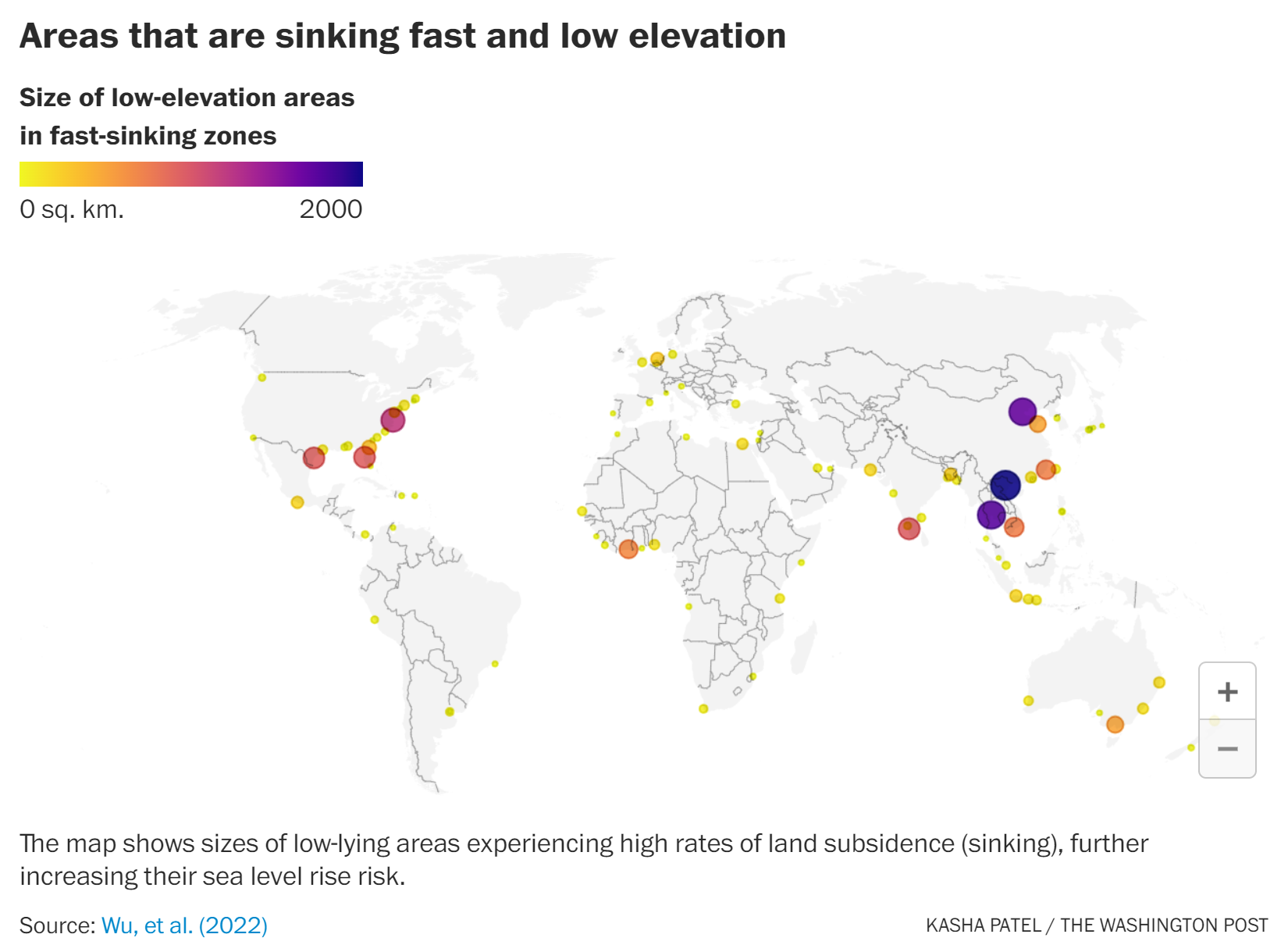
Many of the fastest sinking places in the world appear in populated areas in southeast Asia largely because of groundwater extraction, but the United States also faces substantial land subsidence. There, you may not notice land settling around you in your daily life, but scientists found that many places are sinking faster than global sea levels are rising — increasing flood risk in coastal cities. (Sea levels are rising at an average global rate of about 3.4 millimeters, or 0.13 inches, per year.)
Regions with the highest land subsidence in the United States are mainly located along the East and Gulf Coast, but here we selected a few hot spots around the country.
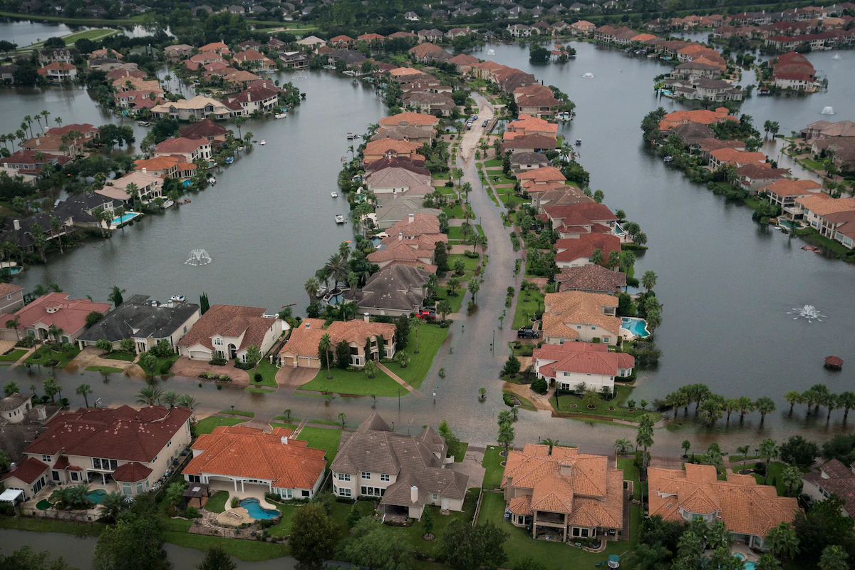
Gulf Coast: Houston
The western Gulf Coast is experiencing some of the fastest land subsidence rates in the United States.
Analyzing land subsidence rates in large coastal cities, Bekaert and his colleagues found Houston hasthe fastest peak subsidence rates — about 17 millimeters (0.67 inches) per year from 2014 to 2020 — in the United States. Other research showed parts of Houston lost over 3 meters in elevation in certain areas since 1917.
Such land subsidence can worsen damage during extreme weather events. Researchers found that the majority of areas flooded during 2017′s Hurricane Harvey showed relatively high subsidence rates.
Land subsidence in the Houston-Galveston area is largely caused by groundwater withdrawals. According to the U.S. Geological Survey, removing water from fine-grained silts and clays underground compresses the aquifer and lowers the land surface. Some regions experience high land subsidence rates because of withdrawal of local oil and natural gas reserves.
A smaller portion of land subsidence can be attributed to fault movement in the area.
Gulf Coast: New Orleans
Parts of New Orleans are also experiencing high rates of sinking, due to both human-induced and natural processes. Research showed that rates are highly variable across the city, ranging from 150 to 500 millimeters (6 to 20 inches) over the past 20 years.
Past data from 2009 to 2012 showed the highest subsidence rates along the Mississippi River near industrial areas in Norco and Michoud — experiencing up to 50 millimeters (2 inches) of sinking a year. To the east of Norco, the Bonnet Carré Spillway, intended to reduce flood risk for New Orleans, experienced up to 40 millimeters (1.6 inches) of sinking a year behind the structure.
NASA reported a primary contributor is pumping groundwater. Subsidence deeper underground is also caused by the shifting of faults, according to the city of New Orleans.
While Houston and New Orleans are notable subsiding locations, other places in the Gulf also experience high rates. In a large area north of Tampa Bay, subsidence rates have been clocked at up to 6 millimeters (0.24 inches) per year, about twice as much as global sea level rise, from 2015 to 2020 due to groundwater pumping. The Tampa Bay area is also relatively flat, meaning rising seas may overwhelm large swaths of the low-lying area. […]
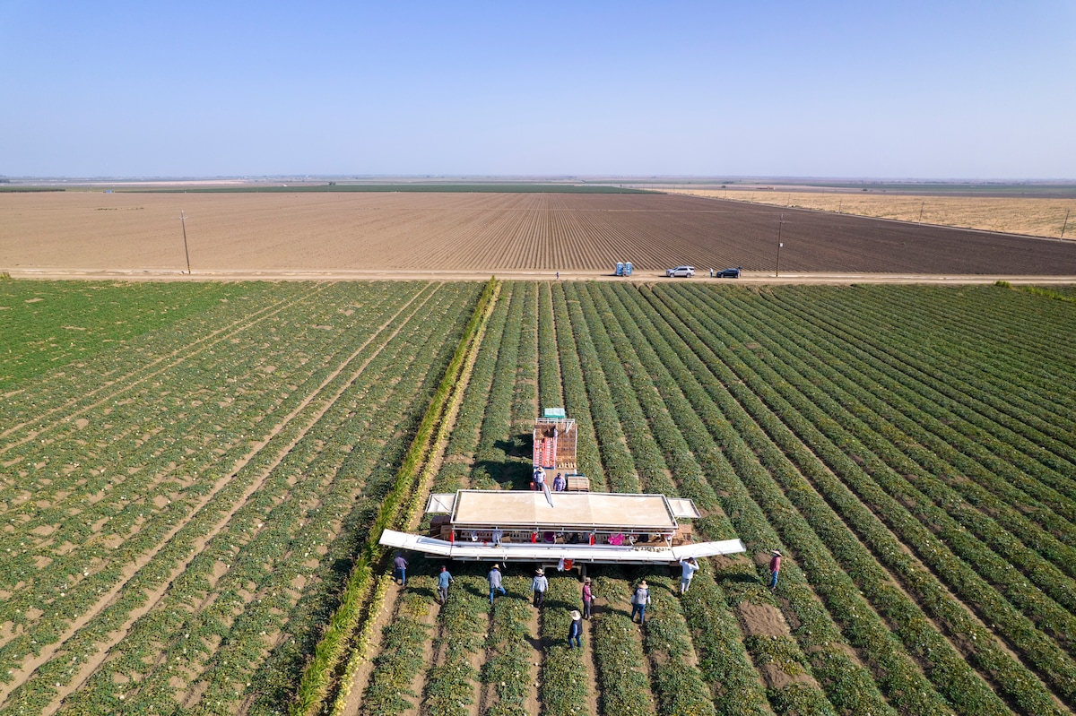
West coast: California’s Central Valley
Sinking along the West Coast is comparatively small to the East Coast, but that doesn’t mean land subsidence isn’t a problem. […]
Further inland in California’s Central Valley, excessive pumping of groundwater for agriculture has caused the land to sink significantly. Since the 1920s, sections of the San Joaquin Valley have sunk by as much as 8.5 meters (28 feet). Groundwater pumping becomes even more problematic during droughts, exacerbating subsidence problems. Data from 2015 showed some spots subsided at rates as high as 600 millimeters (2 feet) per year. [more]
Land around the U.S. is sinking. Here are some of the fastest areas.