September 2019 hottest on record globally, second hottest in U.S. history – All-time record for 12-month rainfall in U.S.

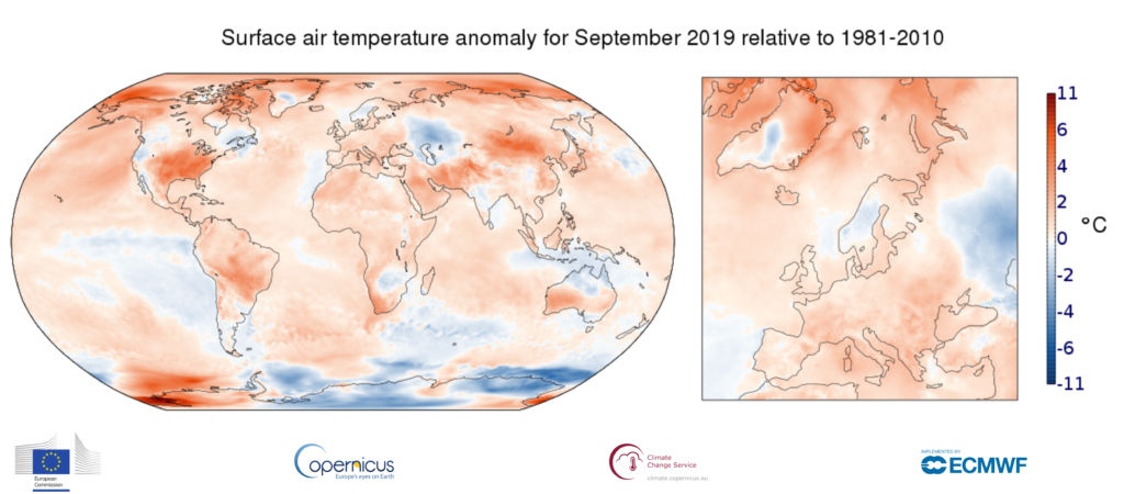
5 October 2019 (Copernicus Climate Change Service) – In Europe, temperatures were above average over most of the continent, especially in the south and south-east. Below-average temperatures occurred over much of Norway and Sweden, and over the far east of the continent. Globally September 2019 was 0.57°C warmer than the average September from 1981-2010, making it the warmest September in our data record, virtually on a par with September 2016. Regions with most markedly above average temperatures include central and eastern USA, the Mongolian plateau and parts of the Arctic. Much below average temperatures were only recorded in a few regions, including southwestern Russia and parts of Antarctica.
Temperatures over Europe for September 2019 were above the 1981-2010 average over most of the continent, especially in the south and south-east. Below-average temperatures occurred over much of Norway and Sweden, and over the far east of the continent.
Elsewhere, temperatures over the northern hemispheric land masses were markedly above average over parts of the Arctic, over most of the USA, and over Iran, Afghanistan, Mongolia and northern China. Temperatures were likewise above average over central South America, South Africa, south-western Australia and West Antarctica.

Temperatures over land were notably below average only over south-western Russia, the Central Asian Republics and parts of Antarctica, although several other regions experienced temperatures that were slightly below average for the month.
Although regions of below-average temperature occurred over all major oceans, including the tropical eastern Pacific, marine air temperatures were predominantly higher than average, especially so over the north-eastern Pacific Ocean and over several Arctic and West Antarctic seas. […]
Global temperatures were substantially above average in September 2019. The month as a whole was:
- 0.57°C warmer than the average September from 1981-2010, making it by a narrow margin the warmest September in this data record;
- 0.02°C warmer than September 2016, the second warmest September;
- 0.1°C warmer than September 2017, the third warmest September. […]
Temperatures averaged over the twelve-month period from October 2018 to September 2019 were:
- much above the 1981-2010 average over most of the Arctic, peaking over and near Alaska and over the central parts of northern Siberia;
- above average over almost all of Europe;
- above average over most other areas of land and ocean, especially so over north-eastern China, the Middle East, south-east Asia, Australia, southern Africa and some parts of the Antarctic;
- below average over several land and oceanic areas, most notably over much of Canada and one sector of Antarctica. [more]
Surface air temperature for September 2019

Second hottest September in U.S. history
By Bob Henson
8 October 2019
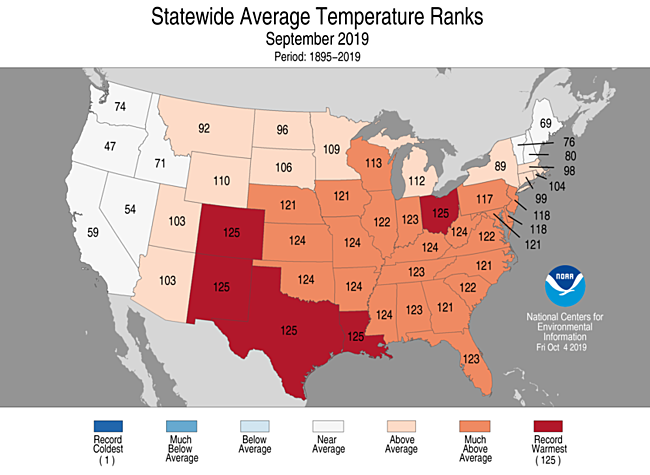
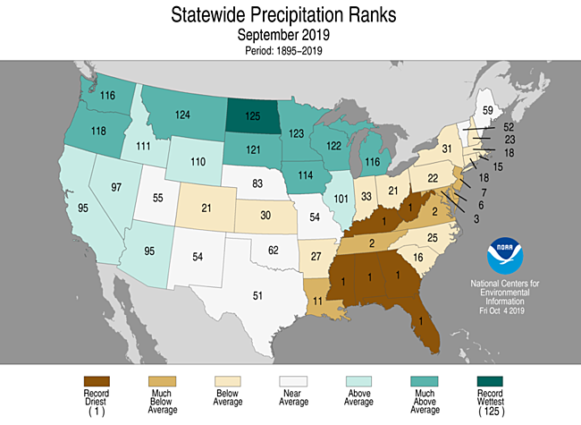
(Weather Underground) – Stoked by record-dry conditions in the Southeast, last month was tied as the second warmest September in records for the contiguous U.S. going back to 1895, NOAA reported on Tuesday. The month was on par with September 2015 and came in behind only the warmth of September 1998.
The heat was widespread, with no states significantly cooler than average. Five states had their hottest September on record—Colorado, Louisiana, New Mexico, Ohio, Texas—and 24 states had a top-five hottest September, covering most of the nation east of the Rockies and south of the Great Lakes and mid-Atlantic.
In NOAA data available through September 26, the month had seen a preliminary total of 2655 daily record highs broken or tied across the 50 states, compared to 85 daily record lows—a ratio of roughly 31 to 1. Many more heat records were set in the final four days of the month, as exceptional warmth covered much of the central and eastern U.S. leading into October.
Evening temperatures were consistently high in many of the hardest-hit areas. The temperature at Dallas-Fort Worth International Airport stayed at or above 72 degrees for the entire month, except for the first day of the month, which hit a low of just 71 degrees. The typical daily low at DFW by the end of September is 62 degrees.

More than 100 cities nationwide had a top-three-warmest September, and more than 50 U.S. locations—ranging from Utqiagvik (Barrow), Alaska, and Hilo, Hawaii, to Colorado Springs, Colorado, and Tupelo, Mississippi—experienced their warmest September on record, as detailed by weather.com. […]
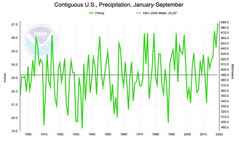
The last 12 months were by far the wettest October-to-September period on record, with 36.45” far outpacing the old record of 35.15” from 1972-73. This is mainly due to the extreme wetness that characterized the period from fall 2018 through spring 2019. The period from October 2018 to September 2019 ranks fifth among the 1496 overlapping 12-month spans going back to January 1895. […]
Amazingly, the nine wettest of these 12-month spans have all occurred in the last six years. [more]


