Record-breaking European heat wave heads north, massive melting likely in Arctic – “This actually primes things for more sea ice loss later, on the order of weeks”
By Bob Henson
29 July 2019
(Weather Underground) – Over the next few days, meltwater will cascade across the Greenland Ice Sheet, and sea ice will dissolve into the Arctic Ocean in amounts that could be unprecedented for late July and early August. The same air mass that led to the sharpest, hottest heat wave ever recorded in northwestern Europe was channeled across Scandinavia over the weekend. Now it’s heading for even higher latitudes. While the North Pole won’t match the 108°F that Paris saw last Thursday, temperatures will be warm enough through a deep enough layer to push melting into overdrive for days, with knock-on effects that could last for weeks.
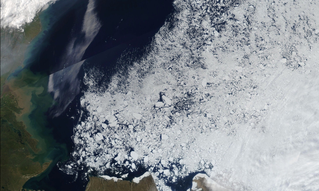
Already, sea ice extent in the Arctic is at record-low values for late July. The five-day average extent for the period ending Sunday, as calculated by the National Snow and Ice Data Center (NSIDC), was 6,576,000 million square kilometers. That’s 263,000 sq km below the record for the date (2011), and 338,000 sq km behind 2012—the year that ended up smashing all previous records for lowest minimum extent by September.
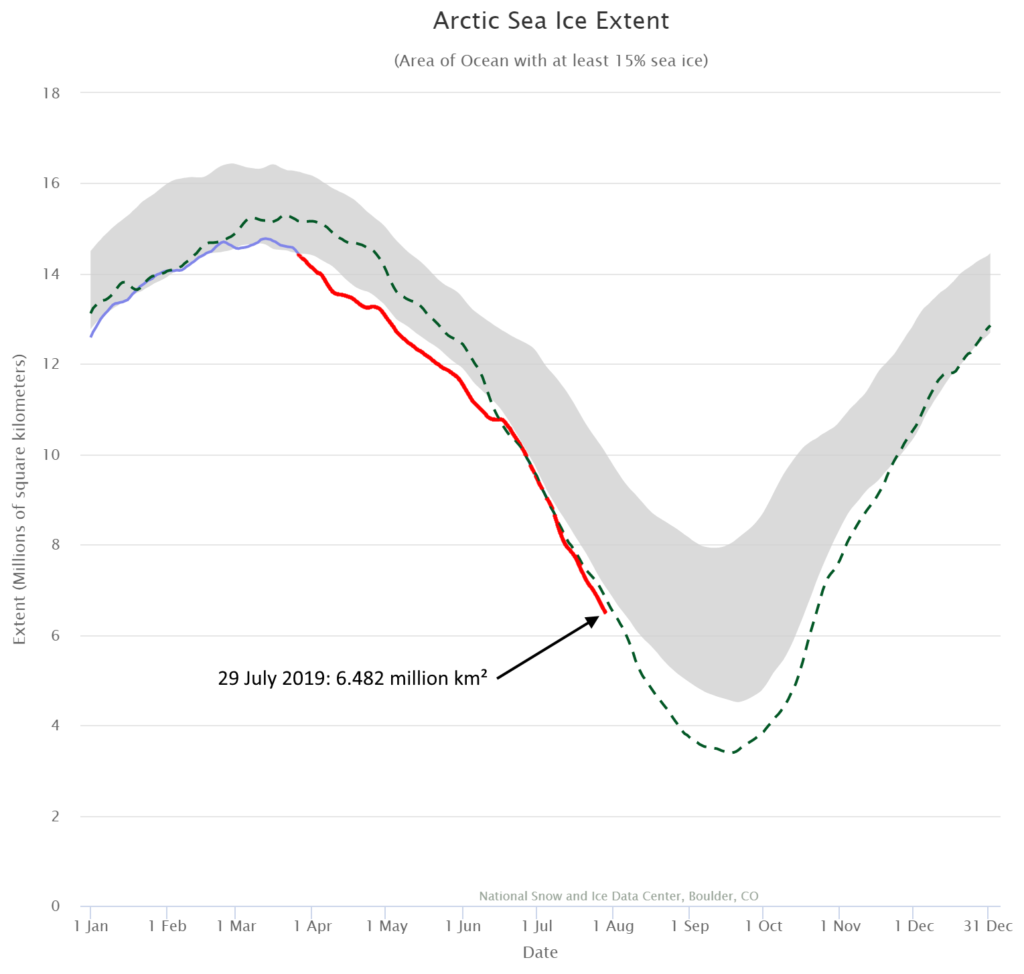
The problem isn’t just two-dimensional. Sea ice volume has also been at record-low levels for the time of year since late June, according to the PIOMAS volume-estimation model operated by the University of Washington. That’s especially worrisome because, for every unit area, less volume implies ice that’s thinner and easier to melt and disrupt. […]
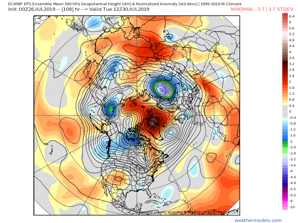
The upper-level high at the heart of Europe’s heat wave has now migrated north into Scandinavia, where it’s joining forces with another very strong upper high over the central Arctic. At the surface, strong high pressure is centered close to the North Pole. The pattern is keeping skies largely cloud-free and allowing still-ample summer sunlight to attack the ice in tandem with the unusual warmth flowing into the Arctic from lower latitudes. “This actually primes things for more sea ice loss later (on the order of weeks),” Cavallo said. “Temperatures will be warmer, and there will be less cloud cover to make sea ice more vulnerable if a cyclone were to develop down the road.” […]
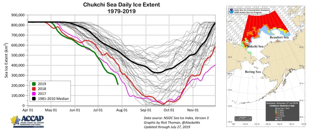
The Chukchi shocker
One area of particular concern is the Pacific side of the Arctic. Periodic infusions of mild air from the North Pacific have led to off-the-charts warmth in Alaska through much of this year. Warm oceanic and atmospheric currents from the south have attacked sea ice in the Chukchi Sea north of Alaska and Siberia, chewing on its fringes while shoving ice toward the Atlantic side of the Arctic.
Ice loss in the Chukchi has gotten especially dramatic over the past few days (see embedded tweet below). Areas of depleted ice cover now extend almost to 85°N on the Pacific side, less than 500 miles from the North Pole, and open water extends to 76°N. […]
Big melt ahead in Greenland
The extraordinarily warm air mass is also likely to set off widespread surface melt atop the Greenland Ice Sheet. Especially concerning is the depth of the warm air—several miles—which will allow it to reach altitudes near the center of the ice sheet. On Friday, Norway’s highest-altitude weather station—Juvvasshøe, perched at 6214 feet—set a new all-time high of 18.9°C (66.0°F). Temperatures may nudge above freezing one or more times early this week all the way to Summit Camp, located at the apex of the Greenland Ice Sheet (elevation 10,551 feet). The camp has gotten as “warm” as 38°F in July, though the average high is in the low teens. The summit temperature was 31°F at midday Monday.
Scientists recognized months ago that 2019 could be a momentous year for Greenland ice. A melting spike in early May focused in southeast Greenland drew notice, and a more widespread round of surface melt in mid-June was the most expansive on record for so early in the year. The melt rate subsided later in June into early July, but then picked up again in recent days. [more]
Heat Wave Heads North: Massive Melting Likely in Arctic
Major Arctic sea ice losses and Greenland Ice Sheet melt near certain next 7 days
By Nick Humphrey
26 July 2019
(Meteorologist Nick Humphrey) – Accelerated melting of both the Arctic sea ice and Greenland Ice Sheet is near-certain the next several days as a very powerful high pressure system sets up over the Arctic Ocean. This will allow for days of clear, sunny weather over the Arctic Ocean and much of Greenland with temperatures above freezing over not only the Arctic Ocean but over the interior of the Ice Sheet. In fact, temperatures will be above freezing not only during the day, but also during the still short nights for many areas of Greenland.
High temperatures Friday (today) over Greenland and the Arctic. Also see the hot weather over Scandinavia. […]
High surface temperature anomalies forecast over Greenland much of next week. Tuesday morning will see average Greenland anomalies +6.3 C above pre-industrial climatology. I adjusted the anomaly shown below (which is based on 1981-2010 climate) by +1.8 C. […]
Here is the Tuesday and Wednesday forecast normalized 500 millibar height anomalies (shows how anomalous the high pressure system in the middle atmosphere). Very anomalously strong high centered over the Greenland Sea. [more]
Major Arctic Sea Ice Losses and Greenland Ice Sheet Melt Near Certain Next 7 Days