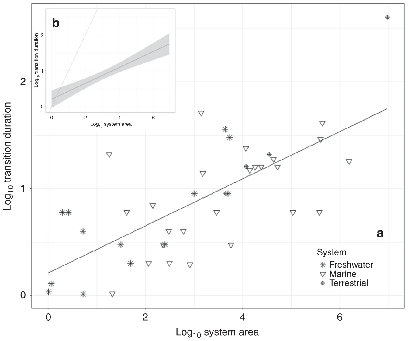
Aerial view of Runit Dome, in Enewetak Atoll, the Marshall Islands, where more than 3.1 million cubic feet of U.S.-produced radioactive soil and debris, including lethal amounts of plutonium, are buried. The so-called “Tomb” now bobs with the tide, sucking in and flushing out radioactive water into nearby coral reefs, contaminating marine life. Video: Carolyn Cole / Los Angeles Times

How the U.S. betrayed the Marshall Islands, kindling the next nuclear disaster – “More than any other place, the Marshall Islands is a victim of the two greatest threats facing humanity: nuclear weapons and climate change”

By Susanne Rust 10 November 2019 MAJURO, Marshall Islands (Los Angeles Times) – Five thousand miles west of Los Angeles and 500 miles north of the equator, on a far-flung spit of white coral sand in the central Pacific, a massive, aging and weathered concrete dome bobs up and down with the tide. Here in […]

Top: Opal Reef in the northern Great Barrier Reef before, during and after the 2016 mass bleaching event. (left to right: September 2015, April 2016, November 2016). Bottom: Double Cone Island in the Whitsundays area of the Great Barrier Reef in 2014, post-cyclone Debbie in 2017 and mid-2018 (left to right). Photo: Taylor Simpkins / Australian Institute of Marine Science

Great Barrier Reef outlook downgraded to “very poor” as threats mount – “We’ve had ten years of warnings, ten years of rising greenhouse emissions, and ten years watching the Reef heading for a catastrophe”

By Peter Hannam 30 August 2019 (The Sydney Morning Herald) – The Great Barrier Reef is at “a critical point” with the marine park’s outlook downgraded on Friday from “poor” to “very poor” due to coral bleaching and deforestation. Climate change resulting in rising sea temperatures was blamed in the federal government’s five-year Great Barrier Reef […]

Remote sensing imagery of discolored water and algal blooms in the Florida Bay and the Florida Keys region between 1992 and 2013 showing connectivity of the mainland and the lower Florida Keys, all outlined in red. (a) Landsat true color image on 29 May 1992 shows turbid water in western Florida Bay and discolored, black water in central Florida Bay that extends southward to the lower Florida Keys; (b) AVHRR reflectance image on 12 March 1996 shows high turbidity from the Shark River Slough plume extending beyond the lower Florida Keys towards Dry Tortugas; (c, d) VIIRS chlorophyll a anomaly images show phytoplankton blooms off Shark River Slough reaching the lower Florida Keys that were partially composed of the cyanobacterium, Synechococcus, on (c) 24 November 2013 and (d) 27 January 2014. Graphic: Lapointe, et al., 2019 / Marine Biology

Nutrient loading lowers resistance to thermal stress in Florida Keys corals – “These data make clear that this is not an ‘either temperature or nutrients’ situation, but rather a ‘both/and’ combination of multiple stressors”

By Gisele Galoustian 15 July 2019 (FAU) – Coral reefs are considered one of the most threatened ecosystems on the planet and are dying at alarming rates around the world. Scientists attribute coral bleaching and ultimately massive coral death to a number of environmental stressors, in particular, warming water temperatures due to climate change. A […]

Map of the 105,000 square miles of coal-rich outback land known as the Galilee Basin in Queensland, Australia. Graphic: The Times

Australia approves vast coal mine near Great Barrier Reef – “An act of climate vandalism that represents everything that has gone wrong with politics in Australia”

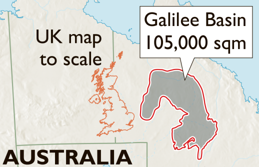
By Andrew Beatty 13 June 2019 (AFP) – Australia approved Thursday the construction of a controversial coal mine near the Great Barrier Reef, paving the way for a dramatic and unfashionable increase in coal exports. Queensland’s government said it had accepted a groundwater management plan for the Indian-owned Adani Carmichael mine—the last major legal hurdle […]

Social media & sharing icons powered by UltimatelySocial