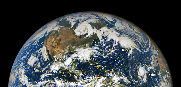
Three hurricanes churn in an active Atlantic Ocean in October 2024 – First-known hurricane season to see three hurricanes simultaneously present in the basin after September

By Emily Cassidy
8 October 2024
(NASA Earth Observatory) – From the stable Lagrange point 1, located one million miles above Earth, NASA’s EPIC (Earth Polychromatic Imaging Camera) imager on the DSCOVR (Deep Space Climate Observatory) satellite observed an unusually active Atlantic Basin.
In early October, three hurricanes simultaneously spun over the North Atlantic Ocean. This image shows the three storms—Milton, Kirk, and Leslie—at about 12 p.m. Central Time (17:00 Universal Time) on October 6, 2024. It was captured as Milton was developing in the southwestern Gulf of Mexico, about an hour before it became a hurricane.
According to Phil Klotzbach, a Colorado State University meteorologist, this is the first-known hurricane season to see three hurricanes simultaneously present in the basin after September. Klotzbach cites the National Hurricane Center’s (NHC) database, which dates back to 1851, but he also noted: “…there are likely underestimates and potentially missed hurricanes prior to the satellite era (1966-onwards).”
Fueled by unusually warm water in the Gulf of Mexico, Hurricane Milton “explosively” intensified from a Category 1 to Category 5 storm in less than 24 hours from October 6-7. The hurricane developed with “light shear and very warm waters in its path,” according to the NHC. As of the afternoon on October 7, Milton had 175 mile (282 kilometer) per hour winds and was forecast by NHC to make landfall on the west coast of the Florida peninsula on the evening of October 9.
In an October 6 update of tropical Atlantic activity, University of Miami hurricane researcher Brian McNoldy noted that temperatures in the Gulf of Mexico—both at and below the surface—were record warm. “High ocean heat content provides a hurricane with a constant source of fuel and makes it much harder to upwell cooler water from below which could weaken the storm,” McNoldy wrote in the update. “This will help Milton to rapidly intensify and reach a higher peak intensity.”
To the northeast, Kirk was weakening from a Category 2 to a Category 1 hurricane around the time of this image. Kirk began developing in the eastern tropical Atlantic in late-September and reached peak intensity as a Category 4 hurricane on October 4. The major hurricane veered northeast after development and evolved into an extratropical cyclone. NHC forecasts indicate that the storm could reach the shores of western France on October 9.
Meanwhile, Leslie churned as a Category 1 storm when this image was acquired. Leslie developed several hundred miles southwest of the Cabo Verde Islands of western Africa and became a hurricane on October 4. The storm is expected to weaken to a tropical storm by October 8, with no interaction with land.
The hurricane season, which started June 1 and runs through November 30, has been unusually busy so far in 2024, according to Klotzbach. As of October 6, nine hurricanes have developed in the Atlantic compared to the 1991-2020 average of 5.5.
Three Storms Churn in an Active Atlantic
![Atmospheric and wildfire responses to soil moisture reduction in the idealized experiments using the CESM2. The values represent differences between the response of a 40% soil moisture reduction perturbation experiment in July 2045 and a control simulation: (a) soil moisture in 0–10 cm depth (units: kg/m2), (b) surface air temperature (units: °C), (c) relative humidity at 2 m (units: %), and (d) logarithm of burned area [log (burned area)] (units: km2). Time evolution over Western Siberia (65.5°N, 83.75°E): (e) soil moisture over 0–10 cm depth (units: kg/m2), (f) surface air temperature (units: °C), (g) relative humidity at 2 m (units: %), and (h) logarithm of the burned area [log (burned area)] (units: km2) (blue: control simulation, yellow: 20% soil moisture reduction perturbation experiment, and brown: 40% soil moisture reduction perturbation experiment). Graphic: Kim et al., 2024 / Nature Communications](https://desdemonadespair.net/wp-content/uploads/2024/10/image-18-1200x675.png)