When burn scars become roaring earthen rivers – “We’re screwed for mudslides”
By Kylie Mohr
1 November 2023
(High Country News) – Two Septembers ago, the residents of Grotto, Washington, woke to the Bolt Creek Fire ripping through the mountains above their homes. “This doesn’t happen here,” Patricia Vasquez remembers saying at the time, shocked. While areas east of the state’s Cascade mountains frequently burn in the summer, Grotto is on the mountains’ western side, in a wetter climate, where fires had been infrequent but are now increasingly common. Vasquez evacuated with her husband, Lorenzo, Ava, their dog, and the fresh Alaska halibut they’d just caught while on vacation. Elizabeth Walther, their neighbor, evacuated with a puppy, but her husband, Richard, a ski patroller, stayed behind to hose down the house.
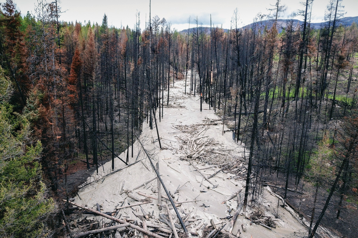
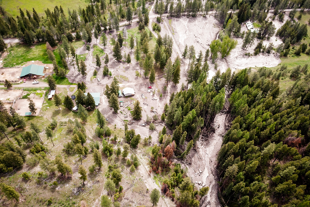
No one was hurt, and no houses burned. But now, wildfire survivors in Washington face a new threat: debris flows. Wildfires can lessen the soil’s ability to absorb water, so when thunderstorms, rapid snowmelt, atmospheric rivers or rain falling on snow occur in a burned area, that can create a roaring earthen river. Debris flows can move quickly — 30 mph or more — sliding from the uplands to the valley floor in a matter of minutes.
Debris flows are more powerful and dangerous than mudslides and slower-moving landslides: They can sweep away boulders, trees and cars and destroy everything in their path, including roads and homes and the people who live in them. Last year, in Washington’s Okanogan County, two residents were rescued from their home after a debris flow. Another flow destroyed a cabin and sent a foot of water and mud into more than 30 structures. And in 2018, 23 people were killed when heavy rains triggered a debris flow in the burn scar of Southern California’s Thomas Fire.
United States Geological Survey (USGS) modeling indicates that, for perhaps the next five to seven years, there’s a high probability of debris flows in the mountains above Grotto and other communities along the South Fork of the Skykomish River Corridor. The USGS models were originally created using data from drier areas in Southern California, where debris flows have been happening for years after fires, and may be less accurate in Washington’s wet climate — particularly on the rainier side of the Cascade Range. And until recently, there’s been little research on how post-fire debris flows behave in Washington.
One May afternoon, eight months after the fire, a team of researchers made their way up a soot-blackened hillside a few miles from Grotto. Ashy dirt crunched underfoot as they scrambled over and around trees that had been toppled by the fire. They were looking for the right tree to mount a game camera on in order to document future debris flows. They also wanted to check on the rain gauges they’d installed last fall, not long after the fire, when rainy weather and still-smoldering stumps had made setting up the equipment extra-tricky.
The Washington Geological Survey’s Wildfire-Associated Landslide Emergency Response Team is tracking recently burned sites in the state to understand when landslides occur and how much precipitation it takes to trigger them. “The missing piece is the exact time,” geologist Kate Mickelson said. The weather patterns, geography and vegetation of the Pacific Northwest are different from California’s, and these variations can influence when the earth slides.
In the Northwest, for example, debris flows can occur several years after a fire, while in California, they usually happen in the first two rainy seasons that follow. (Researchers think that might be because tree roots take longer to decay in the Pacific Northwest.) Generally, National Weather Service debris-flow warnings are triggered if a quarter-inch of rain falls in 15 minutes, or if one inch falls in an hour. Sometimes they’re issued for at least the first two years post-fire, either countywide or just for the area near a burn scar. The warning system’s thresholds can be tweaked to reflect the region. But in rainy parts of western Washington, heavy rain is not unusual, and scientists fear that issuing alerts all the time could numb people to the danger, making them less likely to evacuate. […]
Sitting barefoot in their front yard in May, amid lilac bushes and daisies, Grotto residents expressed their concerns. “We have to cross our fingers,” Lorenzo Vasquez said. “We’re screwed for mudslides,” Richard Walther, his neighbor, agreed. They’re worried that debris flows could reroute the creek between their homes and the mountainside, causing flooding or road damage. The Washington Geological Survey scientists hope their work will help residents prepare in the future. “We would like to be able to tell people, ‘This is your peak risk,’” Mickelson said. “We just don’t know that yet.” [more]