NASA finds Typhoon Bualoi rapidly intensified
By Rob Gutro
21 October 2019
(NASA) – Typhoon Bualoi rapidly intensified over 24 hours and quickly developed an eye and powerful thunderstorms.
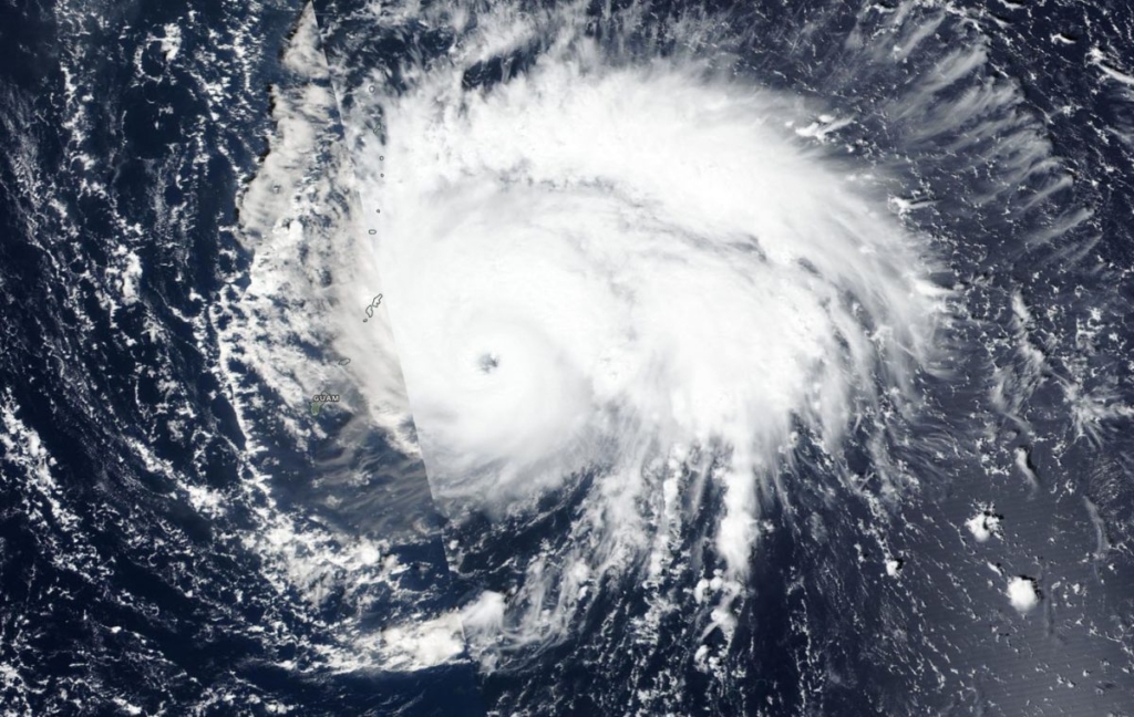
On 21 October 2019, the eye of Typhoon Bualoi was just over 50 miles from the island of Saipan when NASA-NOAA’s Suomi NPP satellite passed overhead. Saipan is the largest island of the Northern Mariana Islands. The Marianas are a commonwealth of the United States in the western Pacific Ocean.
The Visible Infrared Imaging Radiometer Suite (VIIRS) instrument aboard NASA-NOAA’s Suomi NPP satellite provided forecasters with an image of Bualoi revealing a clear eye surrounded by powerful thunderstorms. The Joint Typhoon Warning Center (JTWC) noted at 11 a.m. EDT on Oct. 21, that Tropical Depression 22W (Bualoi) rapidly intensified by 35 knots (40 mph/65 kph) over the past 24 hours from 70 knots (81 mph/129 kph) at 8 a.m. EDT (1200 UTC) on Oct. 20 to the current intensity of 105 knots (120 mph/194 kph).
JTWC also noted “Animated enhanced infrared imagery depicts a 15 nautical mile round eye embedded in a compact, asymmetric convective core.”
Satellite imagery helps forecasters understand if a storm is organizing or weakening. The shape of a tropical cyclone provides forecasters with an idea of its organization and strength, and NASA-NOAA’s Suomi NPP satellite provided a visible image of the storm to forecasters.
Bualoi formed on Oct. 19 as Tropical Depression 22W and strengthened into a tropical storm later that day. It became a typhoon on Oct. 20. [more]