Massive permafrost thaw documented in Canada, portending huge carbon release
BY Bob Berwyn
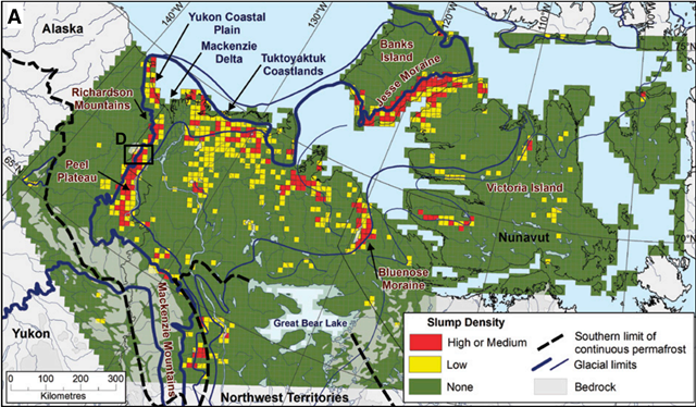
28 February 2017 (InsideClimate News) – Huge slabs of Arctic permafrost in northwest Canada are slumping and disintegrating, sending large amounts of carbon-rich mud and silt into streams and rivers. A new study that analyzed nearly a half-million square miles in northwest Canada found that this permafrost decay is affecting 52,000 square miles of that vast stretch of earth—an expanse the size of Alabama. According to researchers with the Northwest Territories Geological Survey, the permafrost collapse is intensifying and causing landslides into rivers and lakes that can choke off life downstream, all the way to where the rivers discharge into the Arctic Ocean. Similar large-scale landscape changes are evident across the Arctic including in Alaska, Siberia and Scandinavia, the researchers wrote in a paper published in the journal Geology in early February. The study didn’t address the issue of greenhouse gas releases from thawing permafrost. But its findings could help quantify the immense global scale of the thawing, which will contribute to more accurate estimates of carbon emissions. Permafrost is land that has been frozen stretching back to the last ice age, 10,000 years ago. As the Arctic warms at twice the global rate, the long-frozen soils thaw and decompose, releasing the trapped greenhouse gases into the air. Scientists estimate that the world’s permafrost holds twice as much carbon as the atmosphere. The new study was aimed at measuring the geographical scope of thawing permafrost in northwest Canada. Using satellite images and other data, the team studied the edge of the former Laurentide Ice Sheet, a vast expanse of ice that covered two-thirds of North America during the last ice age. The disintegration of the permafrost was visible in 40- to 60-mile wide swaths of terrain, showing that, “extensive landscapes remain poised for major climate-driven change.” “Things have really taken off. Climate warming is now making that happen. It’s exactly what we should expect with climate change,” said Steven V. Kokelj, lead scientist on the Canadian mapping project. “And the maps that we produced clearly indicated it’s not just a random pattern. We’re sort of connecting dots here for the scientific community.” [more]
Massive Permafrost Thaw Documented in Canada, Portends Huge Carbon Release
ABSTRACT: Ice-marginal glaciated landscapes demarcate former boundaries of the continental ice sheets. Throughout circumpolar regions, permafrost has preserved relict ground ice and glacigenic sediments, delaying the sequence of postglacial landscape change that transformed temperate environments millennia earlier. Here we show that within 7 × 10⁶ km2 of glaciated permafrost terrain, extensive landscapes remain poised for major climate-driven change. Across northwestern Canada, 60–100-km-wide concentric swaths of thaw slump–affected terrain delineate the maximum and recessional positions of the Laurentide Ice Sheet. These landscapes comprise ~17% of continuous permafrost terrain in a 1.27 × 10⁶ km2 study area, indicating widespread preservation of late Pleistocene ground ice. These thaw slump, relict ground ice, and glacigenic terrain associations are also evident at the circumpolar scale. Recent intensification of thaw slumping across northwestern Canada has mobilized primary glacial sediments, triggering a cascade of fluvial, lacustrine, and coastal effects. These geologically significant processes, highlighted by the spatial distribution of thaw slumps and patterns of fluvial sediment mobilization, signal the climate-driven renewal of deglaciation and postglacial permafrost landscape evolution.
Climate-driven thaw of permafrost preserved glacial landscapes, northwestern Canada
