Canada’s 2nd largest fire on record spreading smoke to Europe
By Dr. Jeff Masters
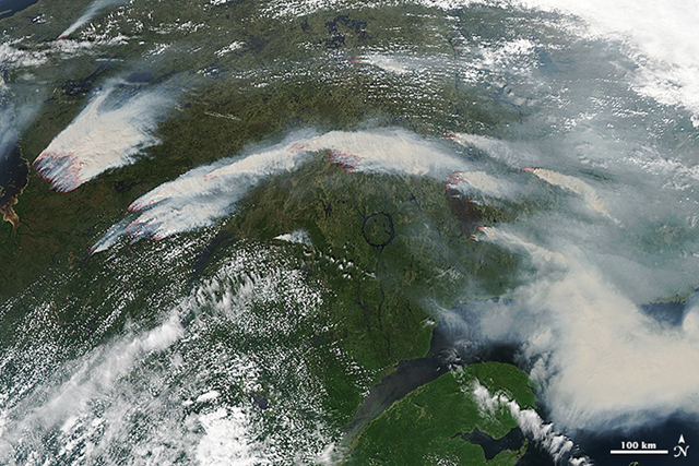
13 July 2013 (wunderground.com) – A massive fire burning in northern Quebec is Canada’s second largest fire since fire records began in 1959, according to the Canadian Forest Service. The fire was more than twice the size of Rhode Island on Tuesday–1,621,000 acres. Called the Eastmain fire, the near-record blaze was ignited by lightning on May 25, and was burning along a 100-km front near the east shore of James Bay by the village of Eastmain. At times, the fire spread at 19 mph (30 kph). The fire cut power to Montreal’s subway system and to 10% of the population of Quebec (500,000 customers) on July 4, when smoke from the fire ionized the air by key hydroelectric power lines, causing a cascade failure. The largest fire in Canadian history was the 2,119,000 acre fire that burned in 1979 in the Northwest Territories. For comparison, the total acreage burned by wildfires in the U.S. as of 4 July 2013 was 1.9 million acres, so the Eastmain fire by itself has burned almost as large an area. The fire’s spread is being limited by the Opinaca Reservoir on its east, and by areas burned in 2002 to the south. The fire spread rapidly last week into a patch along its northern and northeastern sides that burned in 1989 (click here to see the very impressive spread of the fire between 16:45 UTC and 18:22 UTC last Thursday from the Suomi NPP VIIRS shortwave IR instrument; look on the northeastern front of the fire, which is inside the former 1989 fire patch–it spreads extraordinarily rapidly at approximately 10 mph.) While cool and relatively wet weather is expected in Quebec during the coming week, keeping fire danger low, there is speculation by some Canadian fire experts that the Eastmain fire will burn the entire summer unless there are a significant number of consecutive rainy days. Smoke from this summer’s fires in Quebec have crossed the Atlantic and reached Scandanavia, according to ScienceDaily.com. The smoke also passed over Greenland when the crowd source-funded DarkSnow Project was taking samples of the Greenland ice. The DarkSnow Project was designed to see if forest fires are significantly darkening the Greenland Ice Sheet, contributing to melt. [more]
Canada’s 2nd Largest Fire on Record Spreading Smoke to Europe
By Adam Voiland
4 July 2013 On 4 July 2013, the Moderate Resolution Imaging Spectroradiometer (MODIS) on NASA’s Aqua satellite captured this image of wildfires burning in western Quebec near James Bay. Red outlines indicate hot spots where MODIS detected unusually warm surface temperatures associated with fire. The image is centered at 65° West longitude and 55° North latitude. MODIS also observed smoke from the fires moving across the Atlantic Ocean on July 5, July 6, and July 7. By July 8, smoke was drifting over Scandinavia.
