Graph of the Day: Australia rainfall deficiencies, 1 April 2012 – 31 January 2013
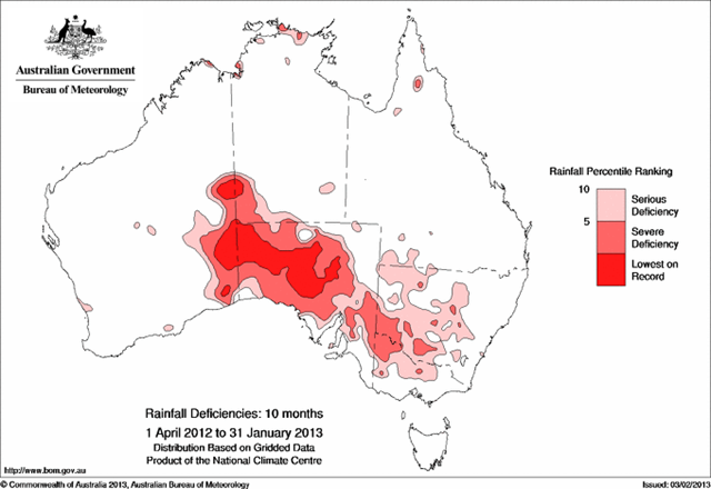
5 February 2013 (National Climate Centre) – Severe rainfall deficiencies for the 6 month (August 2012 to January 2013) period have expanded in central Australia and in large parts of the inland southeast of Australia following below average January rainfall. Severe deficiencies now cover most of South Australia (where August to January rainfall was the lowest on record), large areas of western New South Wales and Victoria, and the southwest corner of the Northern Territory. Temperatures during this 6 month period have also been unusually hot, which is likely to have exacerbated the impact of the below average rainfall. The Australian mean maximum temperature was a record +1.70 °C above average over this period, some 0.21 °C hotter than the previous record set over the same period in 2009/2010. Heavy rainfall associated with ex-tropical cyclone Oswald eased rainfall deficiencies along the immediate east coast of Queensland, but pockets of serious to severe deficiency have emerged over areas inland of the Great Dividing Range. Severe rainfall deficiencies continue in southwest Queensland, as do deficiencies in patches along the north coast of the Northern Territory. Rainfall deficiencies for the 10-month (April 2012 to January 2013) period have expanded over South Australia; an area of lowest on record stretches across much of the pastoral districts and into eastern Western Australia. Areas of severe deficiency have also expanded into western and central New South Wales and Victoria, including the Riverland. [more]
Rainfall deficiencies expand in southern Australia, but ease along the east coast