NASA satellites find record snow didn’t offset Southwest U.S. groundwater loss – “In years like the 2022-23 winter, I expected that the record amount of snowfall would really help to replenish the groundwater supply. But overall, the decline continued.”
By James R. Riordon
17 June 2024
(NASA GSFC) – Record snowfall in recent years has not been enough to offset long-term drying conditions and increasing groundwater demands in the U.S. Southwest, according to a new analysis of NASA satellite data [Snowfall Replenishes Groundwater Loss in the Great Basin of the Western United States, but Cannot Compensate for Increasing Aridification –Des].
Declining water levels in the Great Salt Lake and Lake Mead have been testaments to a megadrought afflicting western North America since 2000. But surface water only accounts for a fraction of the Great Basin watershed that covers most of Nevada and large portions of California, Utah, and Oregon. Far more of the region’s water is underground. That has historically made it difficult to track the impact of droughts on the overall water content of the Great Basin.
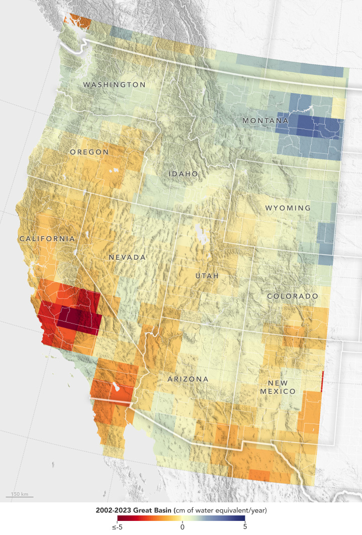
A new look at 20 years of data from the Gravity Recovery and Climate Experiment (GRACE) series of satellites shows that the decline in groundwater in the Great Basin far exceeds stark surface water losses. Over about the past two decades, the underground water supply in the basin has fallen by 16.5 cubic miles (68.7 cubic kilometers). That’s roughly two-thirds as much water as the entire state of California uses in a year and about six times the total volume of water that was left in Lake Mead, the nation’s largest reservoir, at the end of 2023.
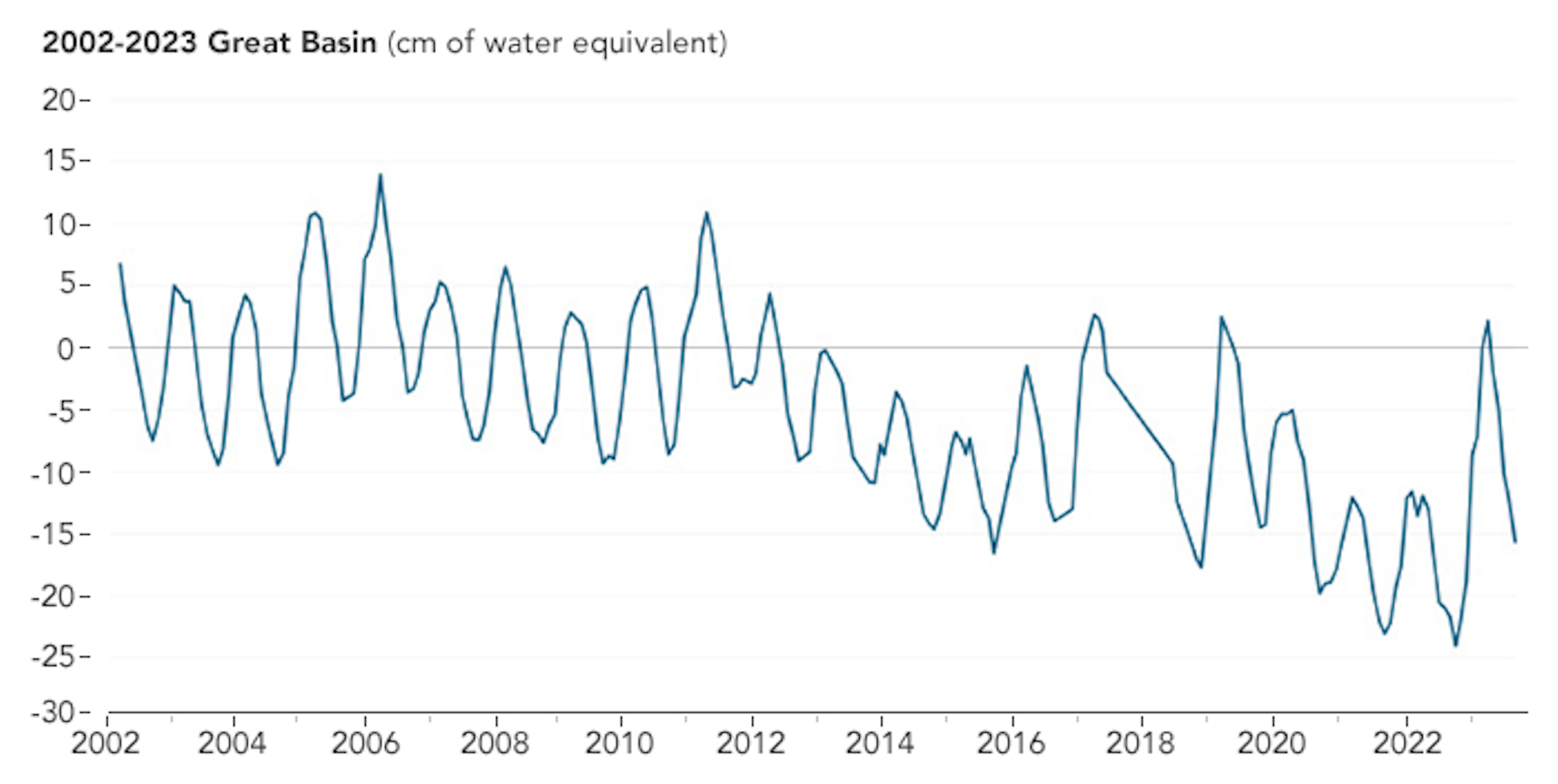
While new maps show a seasonal rise in water each spring due to melting snow from higher elevations, University of Maryland earth scientist Dorothy Hall said occasional snowy winters are unlikely to stop the dramatic water level decline that’s been underway in the U.S. Southwest.
The finding came about as Hall and colleagues studied the contribution of annual snowmelt to Great Basin water levels. “In years like the 2022-23 winter, I expected that the record amount of snowfall would really help to replenish the groundwater supply,” Hall said. “But overall, the decline continued.” The research was published in March 2024 in the journal Geophysical Research Letters.
“A major reason for the decline is the upstream water diversion for agriculture and households,” Hall said. Populations in the states that rely on Great Basin water supplies have grown by 6% to 18% since 2010, according to the U.S. Census Bureau. “As the population increases, so does water use.”
Runoff, increased evaporation, and water needs of plants suffering hot, dry conditions in the region are amplifying the problem. “With the ongoing threat of drought,” Hall said, “farmers downstream often can’t get enough water.”
While measurements of the water table in the Great Basin — including the depths required to connect wells to depleted aquifers — have hinted at declining groundwater, data from the joint German DLR-NASA GRACE missions provide a clearer picture of the total loss of water supply in the region. The original GRACE satellites, which flew from March 2002 to October 2017, and the successor GRACE–Follow On (GRACE–FO) satellites, which launched in May 2018 and are still active, track changes in Earth’s gravity due primarily to shifting water mass.
GRACE-based maps of fluctuating water levels have improved recently as the team has learned to parse more and finer details from the dataset. “Improved spatial resolution helped in this study to distinguish the location of the mass trends in the Western U.S. roughly ten times better than prior analyses,” said Bryant Loomis, who leads GRACE data analysis at NASA’s Goddard Space Flight Center in Greenbelt, Maryland.
The diminishing water supplies of the U.S. Southwest could have consequences for both humans and wildlife, Hall said. In addition to affecting municipal water supplies and limiting agricultural irrigation, “It exposes the lake beds, which often harbor toxic minerals from agricultural runoff, waste, and anything else that ends up in the lakes.”
In Utah, a century of industrial chemicals accumulated in the Great Salt Lake, along with airborne pollutants from present-day mining and oil refinement, have settled in the water. The result is a hazardous muck that is uncovered and dried as the lake shrinks. Dust blown from dry lake beds, in turn, exacerbates air pollution in the region. Meanwhile, shrinking lakes are putting a strain on bird populations that rely on the lakes as stopovers during migration.
According to the new findings, Hall said, “The ultimate solution will have to include wiser water management.”
NASA Satellites Find Snow Didn’t Offset Southwest US Groundwater Loss
Snowfall Replenishes Groundwater Loss in the Great Basin of the Western United States, but Cannot Compensate for Increasing Aridification
There has been an acceleration of groundwater loss in the Great Basin (GB) of the western U.S. as determined from total water storage (TWS) measurements from the GRACE/FO satellite missions. From 2002 to 2023, there was a loss of TWS in the GB of ∼68.7 km3 which is more than six times the current volume of the Lake Mead Reservoir. In this arid/semi-arid region, groundwater is the primary factor contributing to the decade-scale decline in TWS. Stronger declining trends are found in the western versus the eastern GB. Snow loading is the major cause of seasonal fluctuations of TWS in the GB. Despite annual replenishment of groundwater by snow, the downward trend persists even in notable snow years. Likely causes include declining snow mass, upstream water diversions and increased evaporation/sublimation due to increasing temperatures. Dire consequences for humans and wildlife are associated with this large loss of groundwater.
Key Points
- Snow accumulation in the Great Basin (GB) triggers an increase in total water storage (TWS) while snow ablation triggers a drop in TWS
- There is an 68.7 km3 loss of groundwater in the GB from 2002 to 2023 which is more than six times greater than the current volume of Lake Mead
- The 2002–2023 TWS decline in the GB is more pronounced in the western GB than in the eastern GB
Plain Language Summary
The 21st Century megadrought in the southwestern U.S. caused a dramatic acceleration of groundwater loss in the Great Basin (GB) of the western U.S. as determined from changes in the Earth’s gravity measured by the GRACE satellites. Groundwater is a major component of total water storage (TWS) in the GB, but snowfall and snowmelt are the major causes of seasonal fluctuations of TWS. As a snowpack accumulates or melts, water is redistributed causing a rapid regional change in gravity that can be measured from space. From 2002 to 2023, there is a substantial loss of groundwater in the GB of ∼68.7 km3 which is more than six times the current volume of water in the Lake Mead Reservoir in Arizona/Nevada. Stronger declining trends of groundwater loss are found in the western part of the GB while weaker declining trends are found in the eastern part. Despite annual replenishment by snowfall, even in notable snow years like 2010–2011, 2016–2017, 2018–2019, and 2022–2023, the downward trend of groundwater depletion persists. Likely causes for this decline include declining snow mass, upstream water diversions and increased evaporation/sublimation due to increasing air and surface temperatures. Groundwater depletion is associated with dire consequences for humans and wildlife.