Tulare Lake flooding due to snowpack melt seen from space – “The state has both too much water and not enough”
By Jess Thomson
5 May 2023
(Newsweek) – The long-dried basin of Lake Tulare in California has rapidly refilled in the wake of intense rainfall and snowmelt.
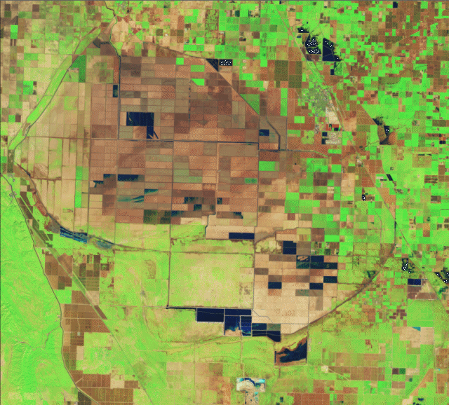
The speed and scale of the southern San Joaquin Valley lake’s return can be seen in images taken from space by the Operational Land Imager (OLI) on NASA‘s Landsat 8 satellite, and the Operational Land Imager-2 (OLI-2) on the Landsat 9 satellite.
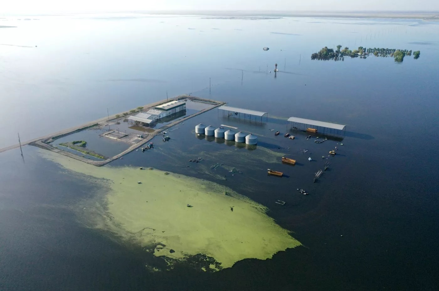
The flooded lakebed has already wreaked havoc across nearby agricultural land, home to, tomatoes, dairy, safflower, pistachios, wheat, and almonds. Further melting of the record-breaking snowpack in the Sierra Nevada mountains is expected to exacerbate the lake’s flooding, as well as the impact on local residents and farmers.
The NASA images are in false color to make the water appear more clearly: vegetation is green, bare ground is brown, and water is dark blue.
Tulare Lake used to be one of the largest freshwater lakes west of the Mississippi River. However, for the past 100 or so years, it has been drained due to the rivers that feed it being dammed and diverted. In the years since, the dried lakebed was overtaken by farms, which grew crops on the fertile lakebed soils.
Now, however, as a result of heavy rainfall across the state due to the several powerful atmospheric rivers that have battered California, and the beginning of the “big melt” from the Sierra snowpack, Tulare has rapidly refilled.
“The story with the flooding in Tulare Lake is that it is a closed basin with no natural outlet,” Nicholas Pinter, professor of applied geosciences and associate director of the Center for Watershed Sciences at the University of California Davis, previously told Newsweek.
“Since draining the lake in the early 1900s, it has been seasonally flooded again in 1938, 1955, 1983, 1997, and 2017. Given the current Sierra snowpack, flooding of the lake is likely to rival and possibly exceed 1983, when 130 square miles of former lakebed were refilled and took 2 years to drain,” he said.
The Lake Tulare region’s agricultural industry is worth around $2 billion, so this flooding will be a massive expense to locals.
“Pastures and dairies have been flooded and cattle have been moved,” United States Department of Agriculture meteorologist, Brad Rippey, previously told Newsweek. “Orchards and fields have been submerged. Trees in orchards that spend time with their roots underwater will soon be lost and will need to be replanted, causing a years-long gap in production for those fruit and nut crops.”
As the record-breaking, four-times average snowpack melts, Tulare isn’t the only area at risk of excess flooding.
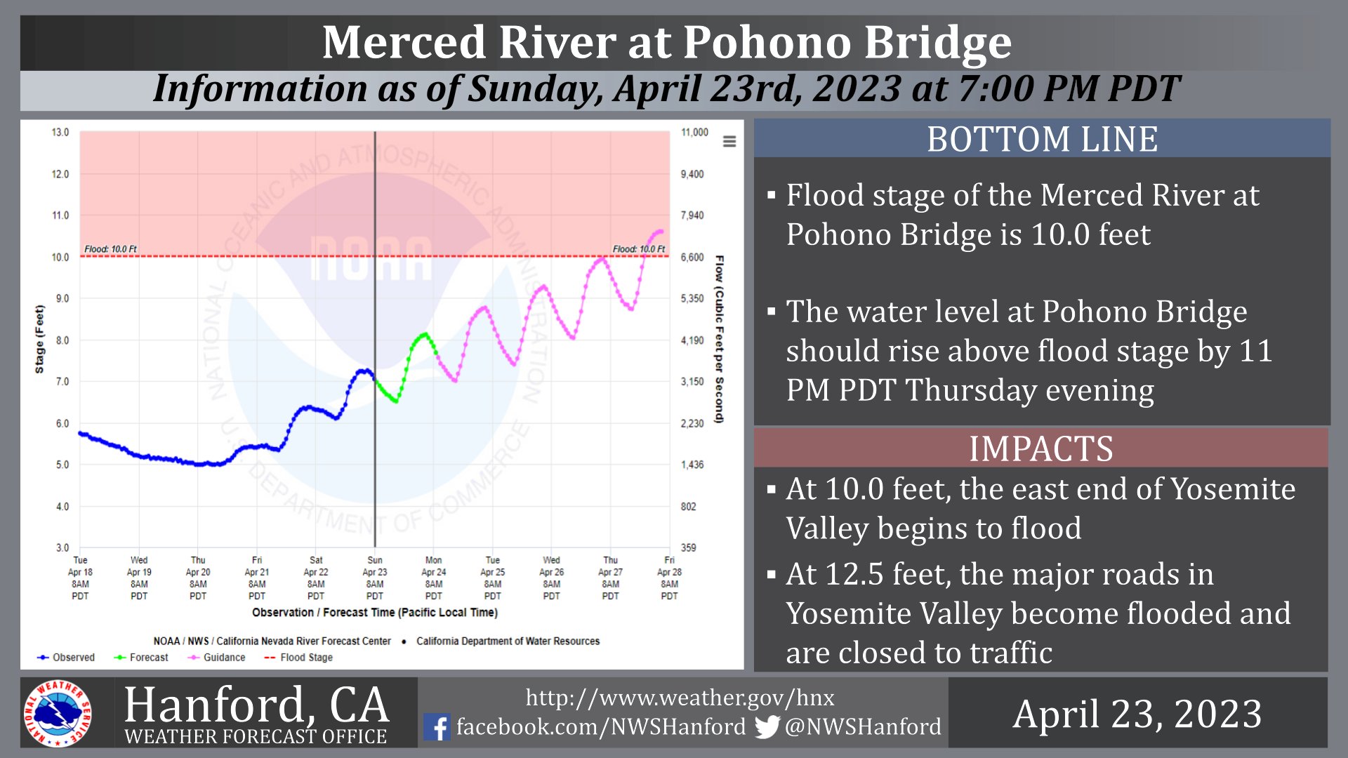
The waterfalls in Yosemite National Park have been flowing at extremely high rates, and there are fears that the Merced River, which flows through Yosemite, may flood during the first week of May. The National Weather Service predicted that the Merced may exceed its 10-foot limit, reaching up to 12.5 feet in some areas. It warned visitors to the park to “use extreme caution anywhere near flowing water; stay back from riverbanks.”
This may be in part due to California’s past two decades in the grip of a megadrought, which has dried out the soil and deplenished the groundwater supplies. This means that the soil struggles to reabsorb water, causing rapidly melting snow to instead run over the ground, leading to flash flooding.
“A recent article [from CalMatters] nicely described this as California’s precipitation paradox: the state has both too much water and not enough,” Keith Musselman, an assistant professor at the Institute of Arctic and Alpine Research at the University of Colorado, Boulder, previously told Newsweek.
“On the one hand, the State has more water than it can handle with more on the way as near-record snowpack in the Sierra Nevada begins to melt. On the other hand, there isn’t enough water to satisfy the State’s long-term needs, and memories of drought stress and wildfire risk are still fresh,” he said. [more]