Super Typhoon Hagibis threatens Tokyo — Massive typhoon could make direct hit on world’s largest metro area
By Bob Henson
9 October 2019
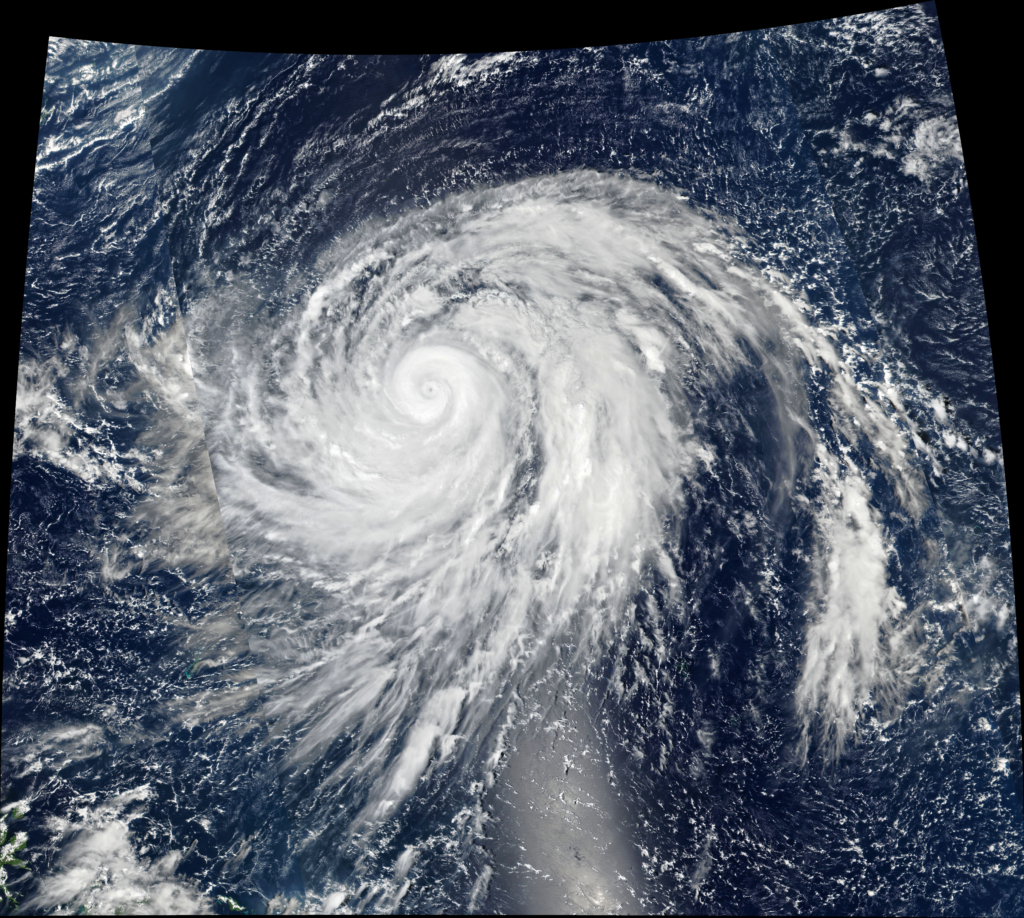
(Weather Underground) – The most intense Northwest Pacific storm of 2019, Super Typhoon Hagibis, is heading toward a potential encounter with the world’s largest metropolitan area, Tokyo. After a slight weakening in Tuesday (from peak winds of 160 to 155 mph), Hagibis was back at Category 5 strength on Wednesday, with top winds of 160 mph as of 8 am EDT.
The speed bump in Hagibis’ strength was the result of an eyewall replacement cycle (ERC), a process that typically dents the peak winds of a tropical cyclone while spreading the core kinetic energy across a larger area. Sometimes, but not always, a storm can rebuild its pre-ERC peak winds within this newly broadened envelope. That was the case with Hagibis, which has drawn on large-scale near-ideal conditions for tropical development.
The very small original eye of Hagibis, only about 5 miles across, was replaced with the new 30-mile-wide eye that was in place on Wednesday. The original eye was encompassed by the new one in a spectacular evolution evident on infrared satellite. The new eye remains surrounded by a solid core of intense thunderstorms (convection), although the shield of strongest convection is now considerably smaller compared to the size of the eye itself. […]
Tokyo may get a late-season hit from Hagibis
Strong typhoons do not typically threaten central Japan as late as mid-October, but Hagibis is an unusual storm. Forecast models are in close agreement on a classic recurving path that will bring the hurricane close to the Tokyo Bay region of Honshu island between Saturday and Sunday local time. The spread among models is more in timing than in track. Because of the angle of approach, though, only a slight shift left or right could result in either a high-impact Tokyo Bay landfall or a glancing brush offshore. […]
The Joint Typhoon Warning Center predicted on Wednesday that the core of Hagibis will move over or near Tokyo Bay around 8 am EDT Saturday as a Category 2 typhoon. This is roughly comparable to the strength of Faxai, which struck Tokyo Bay as a Category 2 typhoon last month, damaging more than 20,000 structures and inflicting as much as $9 billion in damage. One major difference is that Hagibis will be a larger, more long-lived, and more powerful typhoon than Faxai as it approaches Japan, so Hagibis could pack more widespread impacts—including a more significant threat of storm surge—depending on its ultimate trajectory and strength. [more]
Hagibis Threatening Tokyo; New England Facing Prolonged Coastal Storm