Wettest 12 months in U.S. history in April 2019 – “Tremendous rainfall” in southern Texas 300-600 percent of normal May
By Bob Henson
8 May 2019
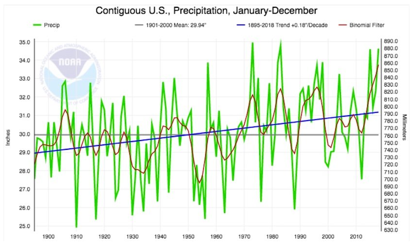
(Weather Underground) – The 12 months ending in April 2019 were the wettest year-long period in U.S. records going back to 1895, according to the monthly U.S. climate summary issued Wednesday by the NOAA National Centers for Environmental Information. Averaged across the contiguous U.S., the total of 36.20” made the period from May 2018 to April 2019 the first year-long span ever to top 36”. The old record for any 12-month period was 35.78”, from April 2015 to March 2016.
Given the fierce drought-related impacts of the 2010s—including multiple deadly wildfire disasters from Tennessee to California—it may seem a bit counterintuitive that the nation has actually been getting wetter overall. Across the contiguous U.S., average yearly precipitation has risen by about 2” over the past century, from around 29” to just over 31” (see Figure 1). For the entire nation, including Alaska and Hawaii, precipitation increased by about 4% in the period from 1901 to 2015, according to the U.S. National Assessment. [more]
Wettest 12 Months in U.S. History
Southern Texas has seen nearly 600% more rainfall than it typically does in early May

By Christina Maxouris
11 May 2019
(CNN) – Golfball-size hail, floods and stranded drivers. This is what May 2019 in Houston is looking like.
The area may have seen a short break in rain but another round of thunderstorms and showers will hammer Houston early Saturday morning through midday, CNN Meteorologist Derek Van Dam said.
With more heavy rain, there’s potential for flash flooding in areas where the ground is already wet, according to the National Weather Service’s Weather Prediction Center. There’s a moderate risk of excessive flooding for southeastern Texas and parts of Louisiana Saturday, the center said.The Upper Texas Coast and the Gulf Coast of western Louisiana has received “tremendous rainfall” in the past week, “300-600% of normal rainfall in that time frame,” the center said.
The region has seen storms moving over the same location for hours at a time — known as training — Van Dam said.
Houstonians will see up to 3 inches of rain Saturday, and areas affected by storms may see heavier showers with up to 5 inches.
Over the weekend, the heavy rain will shift eastward toward Alabama and the southern Appalachians, Van Dam said. As the storm moves east, clusters of storms could produce more flash flood threats, the center said. [more]
Southern Texas has seen nearly 600% more rainfall than it typically does in early May