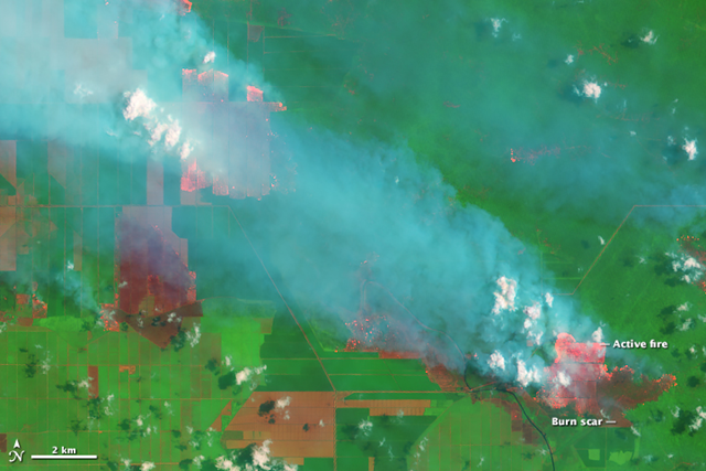
9 October 2015 (Desdemona Despair) – 2015 is likely to be among the worst years for forest fires on record. A lot of this destruction is caused by fires that are intentionally set to clear forests for agriculture. In Sumatra and southern Borneo, rainforest and peatlands are burned to make room for palm oil plantations.  This happens every year, but after extended drought, forests and peatlands in Indonesia are exceptionally susceptible to wildfire. The result is that agricultural business-as-usual is creating a carbon disaster, as deep peat burns, releasing long-sequestered carbon back into the atmosphere. On 5 September 2015, the Operational Land Imager on the Landsat 8 satellite acquired this image of smoke billowing from fires in Jambi Province on the Indonesian island of Sumatra. The fact that the fires burned within well-defined rectangular grids suggests that these were agricultural fires intentionally set by growers. According to land-use maps published by Global Forest Watch, the fires are burning within a palm oil plantation. Photo: Joshua Stevens / NASA / USGS On 5 September 2015, the Operational Land Imager on the Landsat 8 satellite acquired this image of smoke billowing from fires in Jambi Province on the Indonesian island of Sumatra. The fact that the fires burned within well-defined rectangular grids suggests that these were agricultural fires intentionally set by growers. According to land-use maps published by Global Forest Watch, the fires are burning within a palm oil plantation. Photo: Joshua Stevens / NASA / USGS
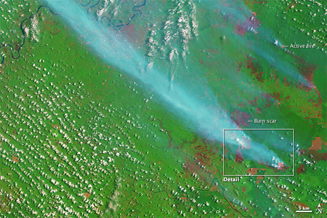
These fires in Jambi province, seen on 5 September 2015, burned within well-defined rectangular grids, showing that these were agricultural fires intentionally set by growers. According to land-use maps published by Global Forest Watch, the fires are burning within a palm oil plantation. Smoke and Fires in Sumatra

  Satellite view of smoke and fires in southern Sumatra and Borneo, 22 September 2015. Photo: NASA Aqua / MODIS 22 September 2015   Smoke from burning rainforest darkens skies over Pontianak, the capital of West Kalimantan, Indonesia, 22 September 2015. Photo: Greenpeace

Smoke from burning rainforest darkens skies over Pontianak, the capital of West Kalimantan, Indonesia, on 22 September 2015. Indonesia forest fires compilation

  As seen in this 24 September 2015 image from the Moderate Resolution Imaging Spectroradiometer (MODIS) on NASA's Terra satellite, peat fires burn in Indonesia as farmers engage in 'slash and burn agriculture.' Red outlines indicate hot spots where the sensor detected unusually warm surface temperatures associated with fires. Thick gray smoke hovers over both islands and has triggered air quality alerts and health warnings in Indonesia and neighboring countries. Visibility has plummeted. Photo: Adam Voiland and Jeff Schmaltz As seen in this 24 September 2015 image from the Moderate Resolution Imaging Spectroradiometer (MODIS) on NASA's Terra satellite, peat fires burn in Indonesia as farmers engage in 'slash and burn agriculture.' Red outlines indicate hot spots where the sensor detected unusually warm surface temperatures associated with fires. Thick gray smoke hovers over both islands and has triggered air quality alerts and health warnings in Indonesia and neighboring countries. Visibility has plummeted. Photo: Adam Voiland and Jeff Schmaltz 24 September 2015   Forest and peatland fires on the border of Gunung Palung National Park, West Kalimantan, September 2015. This forest is orang-utan habitat. Photo: Greenpeace

Forest and peatland fires on the border of Gunung Palung National Park, West Kalimantan, September 2015. This forest is orang-utan habitat. Indonesia forest fires compilation

  Satellite view of smoke and fires in southern Sumatra, 4 October 2015. Photo: NASA Aqua / MODIS 4 October 2015   Satellite view of smoke and fires in southern Sumatra and Borneo, 5 October 2015. Photo: NASA Aqua / MODIS 5 October 2015   Forest and peatland fires on the border of the palm oil concession, Ketapang Regency, West Kalimantan, September 2015. This forest is Orang-utan habitat. Photo: Greenpeace

Forest and peatland fires on the border of the palm oil concession, Ketapang Regency, West Kalimantan, September 2015. This forest is orang-utan habitat. Indonesia forest fires compilation

  Orang-utans living in Kalimantan forest. Photo: Greenpeace Orang-utans living in Kalimantan forest. Indonesia forest fires compilation