Global warming may have amplified record-breaking Texas deluge – Floods are a preview of future extreme weather events
By Elizabeth Harball, Scott Detrow
27 May 2015 (Scientific American) – Large swaths of Houston were underwater yesterday after more than 10 inches of rain fell on the city during a 24-hour window. The bulk of the rain came during intense Monday night thunderstorms, bringing America’s fourth-largest city to a standstill by yesterday morning. Major highways were flooded, schools and mass transit systems were shut down, rivers were swollen above flood stage, and the city’s Emergency Operations Center had declared a Level 1 emergency for the first time since Hurricane Ike struck in 2008. Houston Mayor Annise Parker proclaimed a state of disaster for the city yesterday afternoon. Austin, San Antonio and several other central Texas communities also faced severe flooding over the weekend after several days of intense rain. Texas Gov. Greg Abbott (R) described flooding along the Blanco River between Wimberley and San Marcos as a “tsunami-style” flood. “This huge tidal wave of water just completely wiped out neighborhoods,” he said yesterday. Abbott has now declared a state of disaster in 46 counties or, as he put it, “literally from the Red River to the Rio Grande.” Even before the worst of the Houston flooding, Abbott characterized the flooding as “absolutely massive.” “This is the biggest flood this area of Texas has ever seen,” he said Monday. At least 17 people are dead in Texas and neighboring Oklahoma, according to the Associated Press, with dozens more still missing. Speaking at the White House yesterday, President Obama pledged federal support for what he called “devastating, record-breaking floods.” He noted that Federal Emergency Management Agency personnel had already been deployed to Texas. A state of emergency was declared for 44 Oklahoma counties as of Monday evening, and yesterday Obama made federal disaster aid available in the state. The National Weather Service on Sunday reported a record for total monthly rainfall set at Oklahoma City’s Will Rogers World Airport at 18.19 inches, shattering the previous record of 14.66 inches set in June of 1989. The National Weather Service also reported that multiple daily maximum precipitation records were broken in a number of Texas cities over the long weekend. As of yesterday morning, the agency had recorded over 10 inches of rain in multiple locations in Harris County, where Houston is located, as well as in neighboring Fort Bend County. [more]
Climate Change May Have Souped Up Record-Breaking Texas Deluge
By James Gerken
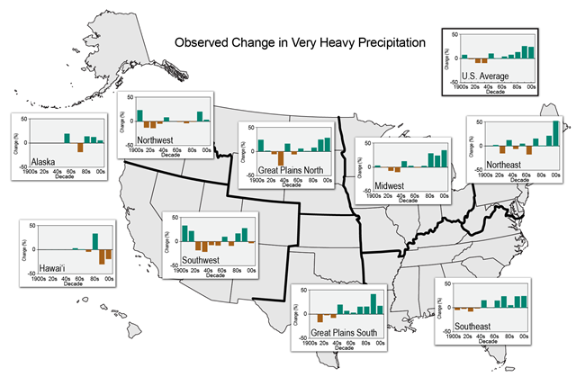
26 May 2015 (The Huffington Post) – Devastating and deadly storms have struck parts of Texas and Oklahoma in recent days, bringing record rainfall and widespread floods that have damaged or destroyed more than 1,000 homes and left at least 16 people dead. “This is the biggest flood this area of Texas has ever seen,” Gov. Greg Abbott (R) said on Monday, according to Reuters. “It is absolutely massive — the relentless tsunami-type power of this wave of water.” The historic and anomalous nature of the flooding raises an important question: Is this climate change in action? At minimum, the recent downpours in Texas probably offer a glimpse of what certain parts of the U.S. can look forward to in the coming decades. As the planet continues to get hotter, in large part due to human activity, warmer air in the atmosphere will hold more moisture. This is expected to alter weather patterns and lead to more frequent and more intense instances of extreme precipitation. For Texas, Oklahoma, and Kansas, the annual amount of precipitation that fell during the heaviest 1 percent of events was up nearly 20 percent last decade compared to the average between 1901 and 1960, according to the most recent National Climate Assessment from the federal government. “Increases in the frequency and intensity of extreme precipitation events are projected for all U.S. regions,” the NCA’s authors warn. In its latest report, the United Nations’ Intergovernmental Panel on Climate Change said that heavy precipitation events in North America and Europe appear to have been growing more frequent and more severe. Furthermore, the panel said, it’s “very likely” that these precipitation events will get worse and surface air temperatures will continue to rise in the coming century. “Overall, we haven’t seen much of a change in annual average rainfall in Texas,” climate scientist and Texas Tech University Professor Katharine Hayhoe wrote in a Facebook post on Sunday. “We expect the future to look much the same, on average. But averaging can drown out the fact that, across the U.S. and Texas, our precipitation is getting more variable — feast or famine, flood or drought.” [more]
Texas Flooding Could Be A Preview Of Future Extreme Weather Events

It will all be attributed to acts of God no matter how bad it gets.
Extreme weather? God did it.
Texans won't admit to global warming at all. Neither will Oklahomans (just look at that idiot Inhofe).
However, God might be responsible. After all, everything that happens is up to him. Right?
It's God's will that we go on polluting the atmosphere and destroying the planet. That's exactly what you hear from most pulpits in the country.