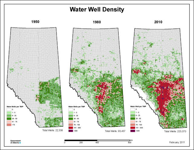
Graph of the Day: Water well density in Alberta, Canada, 1950-2010
4 March 2014 (Alberta ESRD) – Why is this indicator important? Water wells are used to supply groundwater to domestic, agricultural, municipal, industrial and other users in the province. Water wells were first drilled in Alberta in the late 1800s; since then over 220,000 water wells have been drilled and reported. More than 90 per cent of rural Albertans depend on water wells for their water supply. Active water wells pump water from underground aquifers, increasing the demand and putting pressure on our groundwater resources. Unsustainable pumping rates will cause groundwater levels to decline over time as aquifers are depleted. Wells screened* or perforated over multiple aquifers can cause groundwater to drain from one aquifer to another, even when these wells are not in use. Not only will this potentially deplete at least one aquifer, but cross-contamination to other aquifers can occur if the draining aquifer has groundwater of a different or lesser quality. Additionally, water wells that have not been properly constructed or maintained, or wells that are inactive or abandoned, pose significant threats to groundwater resources as they provide a direct conduit for surface contamination to reach our aquifers. *Screened refers to the intake portion at the bottom of the water well casing, which allows groundwater to flow into the well.
What does this indicator show?
The graph below shows the number of reported water wells in Alberta over the past century. This includes water wells reported to Alberta Environment and Sustainable Resource Development through submission of a water well drilling report, as well as those documented in past surveys and inventories. Drilling reports are available through the Alberta Water Well Information Database. Submission of drilling reports was not mandatory until 1978, so the actual number of water wells in the province may be greater than shown below. This graph includes wells that have been abandoned or reclaimed since being reported. The graph shows that while the total number of wells drilled and reported continues to climb at a considerable rate, the actual number of wells reported since 1990 has decreased compared to previous decades. This is attributed to a number of factors such as population trends, increasing portion of rural residents accessing other water sources (e.g., cisterns, municipal supplies) and improved well rehabilitation practices. Water well density is shown below for 1950, 1980 and 2010, showing a significant increase in water wells drilled over time. The number of wells per township illustrates the distribution of water wells across the province. Most wells are concentrated within and around the Edmonton – Calgary corridor, where most of the population and associated development occurs. Higher density areas are where potential impacts to groundwater quantity and quality will be the greatest.
What actions are being taken?
Knowing the density and distribution of water wells is one of the first steps in identifying potential pressures on Alberta’s aquifers. Recent actions taken to address this pressure include initiation of the Edmonton-Calgary Corridor project under the Provincial Groundwater Inventory Program to better understand groundwater resources in this highly developed and populated area. Additionally, the Working Well program launched in 2008, educates landowners on responsible management of their water wells, including decommissioning (plugging) of inactive and unused wells.

