Video: Projected increase in potential evaporation in North America through 2100
9 August 2013 (NASA) – This animation shows the projected increase in potential evaporation through the year 2100, relative to 1980, based on the combined results of multiple climate models. The maximum increase across North America is about 1 mm/day by 2100. This concept, potential evaporation, is a measure of drying potential or “fire weather.” An average increase of 1 mm/day over the whole year is a big change, one we can put in specific terms: We consider a 1 mm/day increase in PE to be an “Extreme” event for fires, something like 2012 in Colorado. By these projections, fire years like 2012 would be the new normal in regions like the western US by the end of the 21st century.
Video: Potential evaporation in North America through 2100 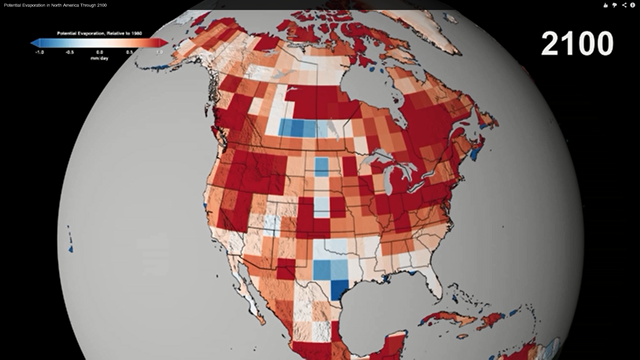
By Kelsey Campbell-Dollaghan
10 August 2013 (Gizmodo) – It’s been a terrible few years for fires, with thousands of homes lost every summer. NASA is using its two earth-monitoring satellites, Terra and Aqua, to help monitor forest fires from space—and to find out how much worse it’s going to get. There are plenty of reasons fires have gotten worse. For one thing, more Americans are building homes in fire-prone areas. And the changing climate has brought pine beetles—which turn living trees into dead kindling—to the Rockies by the droves. But there are also bigger, underlying shifts that are stoking the flames: The increasing dryness of land across the country. NASA describes this concept as “potential evaporation,” a way to gauge how dry the land will be on any given day. Using satellite data going back to 1980, they’ve created a new projection for potential evaporation in America over the next 90 years, releasing the results of the study on YouTube yesterday. As you can see, it doesn’t look great. Using a maximum increase of one millimeter of evaporation per day, their projection shows how “fire country” is set to absorb new parts of the US. “We consider a 1 mm/day increase in potential evaporation to be an ‘Extreme’ event for fires, something like 2012 in Colorado,” NASA’s scientists explain on YouTube. “By these projections, fire years like 2012 would be the new normal in regions like the western US by the end of the 21st century.” [more]
NASA Predicts How Common Forest Fires Will Be By 2100
By Rani Gran
10 August 2013 (Phys.org) – The Black Forest wildfire this June was one of the most destructive in Colorado history, in terms of homes lost. It started close to houses and quickly spread through the ponderosa pine canopies on the rolling hills near Colorado Springs. The wildfire destroyed 500 homes in the first 48 hours and killed two people. Hot, dry and windy weather played a role in that wildfire, said Don Smurthwaite, spokesperson with the National Interagency Fire Center (NIFC) in Boise, Idaho. “Fire seasons are getting longer, western regions are getting drier, and more people are living closer to fire-prone areas.” Fire scientists have observed those conditions becoming more prevalent across the United States. As the western United States enters what is typically the most active time of its fire season, scientists, firefighters and residents are keeping close watch on what’s burning – not just this year, but over the long term. As temperatures warm and weather patterns change, scientists from NASA, universities and other government agencies are putting their satellite observation and computer modeling capabilities to work. They are grappling with what the future landscape of fire will look like in the American West. “Over the last 30 years we have seen an increase in hot and dry conditions that promote fire activity,” said Doug Morton, a scientist at NASA’s Goddard Space Flight Center, Greenbelt, Md. “And across the western U.S. and Alaska, satellites show an increase in the area that burns each year over that same time period.” As of Aug. 8 this year, wildfires have burned more than 2.5 million acres in the United States. Large wildfires are mainly driven by natural factors including the availability of fuel (vegetation), wind, and ignition sources from lightning and humans. For more than a decade, instruments on Terra and Aqua, two of NASA’s flagship Earth-observing satellites, have scanned the surface of our planet for fires. An instrument on both satellites, the Moderate Resolution Imaging Spectroradiometer (MODIS), has revolutionized what scientists know about fire’s role in land cover change, ecosystem processes and the global carbon cycle by allowing researchers to map characteristics of the global distribution of fires in remarkable detail. [more]