Record rainfall in Little Rock, Hanover, Melbourne
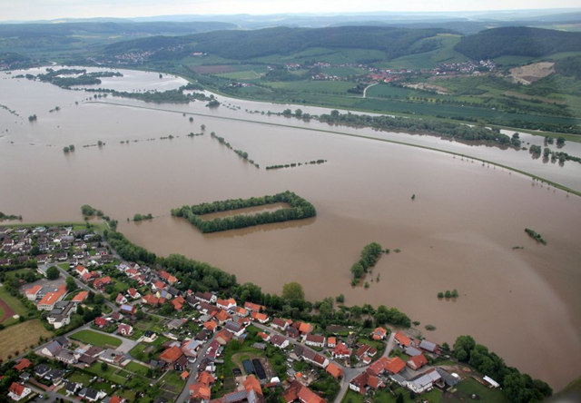
[A warmer world is a wetter world: record rains on three continents. –Des] 31 May 2013 (Spiegel) – Rain, rain and, yes, more rain. Welcome to Germany! For weeks, rain has been pounding Germany, whose serotonin-sapped residents are straining to hold on to the last vestiges of hope after already having suffered through the darkest winter in over four decades. But, save for a few soon-forgotten days of sunshine, most of Germany’s vitamin-D-deprived residents have had to live through endless days of gray drizzle and downpour this spring. Though summer is officially just around the corner, refrains of “Can you believe this (insert expletive) weather?” have given way to silent, knowing looks and forlorn sighs. Indeed, April showers have only been followed by more showers in May, when 178 percent more rain fell than the year before, according to estimates of Germany’s National Meteorological Service (DWD). What’s worse, the DWD says that — except for in a lucky few parts of northwestern Germany — Mother Nature has no plans to turn off the spigots anytime soon. The DWD issued extreme weather warnings on Friday for the southern states of Bavaria and Baden-Württemberg as well as regions of Thuringia, Saxony-Anhalt and Hesse, saying that up to 70 liters (18.5 gallons) of rain could fall per square meter (10.7 square feet). The rains could also spread to parts of Hesse and Lower Saxony. Already for days, areas in the northern state of Lower Saxony have been fighting floods caused by overflowing rivers. A cyclist drowned in the capital city of Hanover on Thursday when she fell while riding on a closed, flooded highway and was washed away by the current. Police reports said that water levels were only slightly receding on Friday. Similar flooding has been seen in many other German locations, where waters are filling basements, trapping inhabitants, closing small and major roads, and felling trees. “The weakened earth can no longer hold tree roots,” said one police spokesman, adding that the rains have caused several landslides that blocked streets. The culprit behind the current round of misery is a low dubbed “Dominik.” On Friday, the depression was east of the Alps and drawing air from the north. The DWD says that a low over Central Europe has been strengthening the weather effects for weeks. As a result, clouds are being pulled over Germany from north to south, where they climb up the Alps, cool off and then dump heavy rain. Although the pattern is not atypical, the DWD says, it usually doesn’t last for weeks. Between early Saturday and early Sunday, meteorologists are expecting to see up to 100 more liters of rain per square meter in the Alps. In certain spots of heavy congestion, this could even rise to 150 liters per square meter — or more than typically falls in an entire month. In fact, the DWD says that, from Germany’s northern coastlines to the Alps, the earth is wetter than it has been in 50 years. This broad swath of muddy soil is causing major problems for the agricultural industry, the DWD reports, making it impossible to drive on 40 percent of fields, use machinery or spray against pests, diseases, molds or weeds. Vegetable growers are getting the worst of it. In some fields of Lower Saxony, the water almost completely hides the raised rows of dirt in which the country’s beloved asparagus is grown. The waters could also severely damage the upcoming harvest of early potatoes. “Even if they haven’t already rotted in the ground, now you can’t harvest them,” said a DWD spokesman. [more]
Rain, Rain, Go Away: Germany Drowns in Endless Downpour 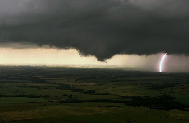
By Suzi Parker
31 May 2013 LITTLE ROCK, Arkansas (Reuters) – The National Weather Service issued a tornado watch for parts of Oklahoma on Friday, describing weather conditions as “particularly dangerous” a day after more than a dozen reported twisters ripped through the region. Forecasters said several intense tornadoes were likely, along with storms bringing up to 4-inch hail and damaging wind gusts that could reach 80 miles per hour. “An extremely unstable air mass has developed across much of Central (and) Eastern Oklahoma,” the weather service said in an advisory. “This will likely result in rapid development of severe thunderstorms this afternoon and evening.” Forecasters said the winds would pose an increasing threat through the evening and urged residents to watch for severe weather. “This is a particularly dangerous situation,” the advisory said. Storms in Oklahoma and Arkansas on Thursday left an Arkansas county sheriff dead and at least one man missing in an attempted water rescue, while at least seven other people were injured elsewhere, officials said. Brian Smith, a National Weather Service forecaster in North Little Rock, said damage assessment teams were surveying several counties on Friday after the reports of several tornadoes. Several storms produced straight-line wind damage and heavy repeated rain, causing flash flooding across Arkansas, he said. Little Rock received more than 3 inches (7.6 cm) of rain in an hour, breaking the hourly record for the state capital, with more thunderstorms and heavy rain possible on Friday, he said. [more]
More severe weather and tornadoes forecast for Oklahoma 
OKLAHOMA CITY, 1 June 2013 (Associated Press) – Nine people have died in the Oklahoma City area after a violent burst of tornadoes and thunderstorms overnight. Amy Elliott with the Oklahoma Medical Examiner’s Office said this morning that nine fatalities have been confirmed, including two children and seven adults. The previous overall total was seven deaths. Hospital officials said at least 75 people were hurt during Friday night’s storms that hit at rush hour. Emergency officials set out this morning to see how much damage a violent burst of thunderstorms and tornadoes caused as it swept across the Midwest overnight, killing at least nine and injuring dozens. The storm toppled cars and left commuters trapped on an interstate highway as it bore down during Friday’s evening rush hour near Oklahoma City. The National Weather Service reported “several” tornadoes rolled in from the prairie, terrifying towns along their paths. The storms brought another tense day for a region still reeling from the recent top-of-the-scale EF5 tornado that struck the Oklahoma City suburb of Moore on May 20, killing 24 and decimating neighborhoods. Many said they took severe weather warnings issued during the day Friday seriously. […] Storm chasers with cameras in their cars transmitted video showing a number of funnels dropping from the supercell thunderstorm as it passed south of El Reno and into Oklahoma City just south of downtown. As the cell advanced, police urged motorists to leave Interstate 40 and seek a safe place. Violent weather also moved through the St. Louis area. Early aerial images of the storm’s damage showed homes with porches ripped away, roofs torn off and piles of splintered wood scattered across the ground for blocks. Officials in St. Charles County also reported that local schools suffered some damage. Among the nine dead in Oklahoma were a mother and a baby found in a vehicle. Amy Elliott, a spokeswoman for the state medical examiner, said today that the death toll was up to seven adults and two children. At least 75 people were hurt, five critically, hospital officials said. Meteorologists had warned about particularly nasty weather Friday but said the storm’s fury didn’t match that of the tornado that struck Moore. The Friday storm, however, brought with it much more severe flooding. It dumped around 8 inches of rain on Oklahoma City in the span of a few hours and made the tornado difficult to spot for motorists trying to beat it home, said Bruce Thoren, a meteorologist with National Weather Service in Norman. “Some tornadoes are wrapped in rain, so it’s basically impossible to see, which is extremely dangerous,” Thoren said. “Somebody driving along really not familiar with what’s going on can basically drive into it.” The heavy rain and hail hampered rescue efforts in Oklahoma City. Frequent lightning roiled the skies well after the main threat had moved east. Highways and streets were clogged late into the night as motorists worked their way around flooded portions of the city. Roads all around Oklahoma City were inundated with muddy water this morning. Will Rogers World Airport was slowly reopening and some flights were resuming. But the airport reported significant damage to the roof of the terminal, and flooding damage to walls, counters and floors. Emergency officials reported that numerous injuries occurred in the area along I-40, and Randolph said there were toppled and wrecked cars littering the area. Standing water was several feet deep, and in some places it looked more like a hurricane had passed through than a tornado. More than 86,000 utility customers were without power. […] National Weather Service meteorologists said today that it’s unclear how many tornadoes touched down as part of the Friday evening storm system. Dozens of tornado warnings were issued for central Oklahoma and parts of Missouri, especially near St. Louis, they said, but crews must assess the damage before determining whether it was caused by tornadoes or severe thunderstorms. [more]
Death toll in Okla. storms rises to 9 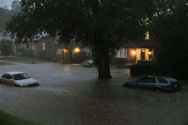
OKLAHOMA CITY, 1 June 2013 (Associated Press) – The Oklahoma City area is experiencing flooding in the wake of Friday’s storms that inundated the region with several inches of rain.
Aerial images show muddy water covering roadways around Oklahoma City and El Reno, about 30 miles west of Oklahoma City. National Weather Service meteorologist Rick Smith said Saturday that parts of the Oklahoma City area received 8 inches of rain overnight. The Oklahoma County Sheriff’s Office said Saturday in a news release that several areas are flooded and that deputies helped with more than 10 high-water rescues overnight. The sheriff’s office is also searching for a man whose vehicle was found washed off the road.
Oklahoma City area flooding after heavy rain 
By Barclay Nettleford
June 01, 2013 (AAP) – Record rainfall in Melbourne has petered out, but more downpours are expected to drench Victoria’s northeast.
Five Melbourne drivers had to be rescued after becoming stranded in floodwaters, with rain causing minor damage as fierce thunderstorms and lightning shook the city on Friday night. Bureau of Meteorology duty forecaster Michael Halfpenny said by 9am (AEST) on Saturday, the city had received 48.6 millimetres of rain in 24 hours. As the 24-hour period ends at 9am on June 1, it will be counted as June rainfall, and makes it a record for a June day. The entire June average is 49.2 millimetres, with the previous June record standing at 44.2 millimetres in 1904. “We’ve received a month’s June rain in 24 hours. It’s extremely unusual,” Mr Halfpenny told AAP. He said since 9am the city received only 0.6 millimetres of rain with isolated showers to continue into the weekend.
“If you include the 0.6, we’ve equalled the June average,” Mr Halfpenny said. Melbourne’s northern suburbs were soaked overnight with Epping, Preston, Somerton, and Blackburn receiving between 100 and 110 millimetres of rain. Rain is expected to continue to hit the northeast of the state, including Victoria’s Alpine region with 20 to 30 millimetres expected on Saturday. […] Severe flood warnings have been issued for Victoria’s Mallee, Wimmera, Northern Country, North East, West and South Gippsland, and East Gippsland districts. [more]
Record rainfall hits Melbourne
At top story, ml has been mis-named as more liters, still amazing rainfall