Typhoon Bolaven hits Okinawa, takes aim at China and Korean peninsula, drags Typhoon Tembin back to Taiwan
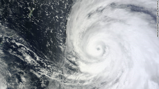
Tokyo (CNN) – A massive typhoon began to make landfall Sunday over Okinawa, bringing winds more ferocious than even the typhoon-weary Japanese island has seen in decades. It will likely be the strongest since 1956, said CNN International meteorologist Tom Sater. With a cloud field of 2,000 kilometers (1,250 miles), Typhoon Bolaven is 20 times larger than Okinawa’s length. “It’s been very, very severe,” said storm chaser James Reynolds, on the northwestern coast of the island. Tree branches were flying through the air amid torrential rain, he said. […] On Sunday evening, Bolaven was carrying sustained winds of 213 kilometers (132 miles) per hour, with gusts reaching 259 kilometers per hour (161 mph) — the highest since Typhoon Naha in 1956. Bolaven was traveling northwest at 15 kilometers per hour (9 mph). The storm is on course to hit China and the Korean peninsula. It’s “roughly the size of France to Poland in land mass,” said Sater. “The typhoon is producing wave heights of 16 meters high, so the possibility is there for a storm surge of 8 to 10 meters high on the coastline. Wind gusts will be strong enough to not only uproot or down trees and power lines, but could flip automobiles. “Okinawa is 100 kilometers (62 miles) long. The size of Bolaven’s eye is roughly 30 kilometers (19 miles) in width. This means many residents could experience the eye passing over them; unfortunately, that means putting up with the strongest winds the storm can produce, followed by a calm period with a brief clearing of the skies overhead, then another chaotic period of damaging winds that will be blowing in the opposite direction of the previous winds.” Rainfall totals could top 500 mm (20 inches) in 24 hours, said Sater. Storm surges are expected to be a major problem for Okinawa. Highways on low-lying barrier islands could be completely washed out, with surges at the coast expected at about 8 meters (26 feet) high. More than 400,000 people in the area live in elevations less than 50 meters (164 feet). Some low-lying areas have been evacuated. “The storm will continue with typhoon strength into the East China Sea, then into the Yellow Sea with its eyes on the Korean Peninsula,” Sater said. Taiwan could be in for a pounding due to something called the Fujiwhara effect, he said. Typhoon Tembin made landfall in southern Taiwan a few days ago, and was expected to work its way toward Hong Kong. But Bolaven, which is much stronger, has stopped Tembin’s movement toward Hong Kong and has been spinning it around. Tembin is likely to make a second landfall in southern Taiwan. “As Typhoon Bolaven moves northward towards the Yellow Sea, it will drag Tembin toward the China coast very near Shanghai,” said Sater. “That’s an amazing change in direction.”
Massive Typhoon Bolaven slamming Okinawa, heads for Koreas 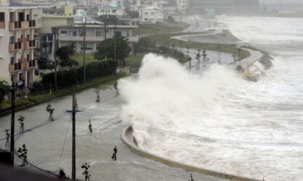
TOKYO (AP) – A powerful typhoon lashed the southern Japanese island of Okinawa and surrounding areas Sunday, injuring four people and cutting off power to about 57,000 households. Weather officials had warned that Typhoon Bolaven would be the strongest to hit the region in several years, but its gusts weren’t as powerful as feared. Disaster authorities reported no major damage as of early Monday aside from the blackouts. The center of slow-moving storm, the 15th of the season, passed over the island late Sunday and was expected to move northwest into the East China Sea on Monday, possibly affecting coastal areas of South Korea by Tuesday, weather officials said. The Japan Meteorological Agency said wind speeds near the center of the typhoon were about 180 kilometers per hour (112 mph), with gusts reaching 252 kph (155 mph), possibly equaling or surpassing past records for the area. Public broadcaster NHK had warned that such strong winds could overturn cars and knock over telephone poles. But NHK reported that the gusts measured on the island of Amami, north of Okinawa, reached just 140 kph (87 mph). “The winds weren’t as strong as expected. We’re glad there’s no major damage so far,” said Yoshimitsu Matsusaki, an official with the Okinawa government’s disaster prevention and crisis management division. Authorities also scaled back the amount of rainfall expected over the most intense 24 hours to about 350 millimeters (14 inches) from 500 millimeters (20 inches) earlier. About 43,000 households on Amami island were without electricity, and 14,000 households on Okinawa also lost power, NHK reported. Video footage from Naha, the prefectural capital, showed trees thrashed by the high winds and driving rain in largely empty streets. On Amami island, some 2,450 households were ordered to evacuate to public shelters. Okinawa disaster authorities said four people were hurt. All domestic and international flights in and out of Naha Airport were canceled. […]
Powerful typhoon lashes Japan’s Okinawa island 
By Tim Culpan
26 August 2012 Taiwan maintained a sea warning as Typhoon Tembin reapproached after already passing through, the Central Weather Bureau said on its website today. Tembin was centered 430 kilometers west-southwest of Taiwan’s southern tip at 11:00 p.m. local time today, heading east and shifting to east-northeast at 6 kilometers to 12 kilometers per hour, it said. Meteorology officials lifted a land warning yesterday. Agricultural damage in Taiwan from Tembin exceeded NT$168 million as of 10 a.m. today, the Council of Agriculture said on its website.
hi,
super typhoon bart of 22nd sept 1999 ( cat 5 ) , was stronger than typhoon bolaven ( cat 2 ).
after that comes super typhoon vera ( cat 5 ) on 26th sept 1959.
punch into google search TYPHOON BOLAVEN VERSUS SUPER TYPHOON BART- VADAKAYIL.
capt ajit vadakayil
..