Massive landslide in Alaska sweeps over glacier, possibly the largest landslide ever recorded in North America
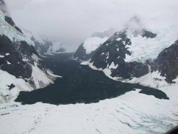
ANCHORAGE, Alaska, 12 July 2012 (AP) – Even by Alaska standards, the rock slide in Glacier Bay National Park was a huge event. It was a monumental geophysical event that was almost overlooked until a pilot happened to fly over where the cliff collapsed and snapped some photographs nearly a month later. When the cliff collapsed in the national park in southeast Alaska on June 11, it sent rock and ice coursing down a valley and over a lovely white glacier in what perhaps was the largest landslide recorded in North America. The rumbling was enough so that it showed up as a 3.4-magnitude earthquake in Alaska. The seismic event also was recorded in Canada. The massive landslide occurred in a remote valley beneath the 11,750-foot Lituya Mountain in the Fairweather Range about six miles from the border with British Columbia. “I don’t know of any that are bigger,” Marten Geertsema, a research geomorphologist for the provincial Forest Service in British Columbia, said Thursday, when comparing the landslide to others in North America. […] Despite the extraordinary size of the landslide, which was estimated at a half-mile wide and 5 1/2 miles long, it went virtually unnoticed until air taxi pilot Drake Olson flew over it on July 2. The landslide, which rolled over the glacier, is not very noticeable to the thousands of cruise ship passengers that visit Glacier Bay National Park near Juneau each summer. That is because it is about 12 to 15 miles up the glacier from the bay. While this one was huge by North American standards, bigger ones have occurred, including a September 2002 landslide in Russia that extended for 20 miles, Geertsema said. […] Scientists also are looking at the role of climate change. “We are seeing an increase in rock slides in mountain areas throughout the world because of permafrost degradation,” Geertsema said. Permafrost is ground that stays perpetually frozen. Geertsema said Swiss scientists are becoming increasingly convinced that climate change is playing a role in the frequency of rock slides after looking at data from instruments measuring temperature and the widening and narrowing of gaps in the rocks in the Alps. “It plays an important role,” Geertsema said, of climate change. “I think we have been underestimating the role it might play.” […]
Massive landslide in Alaska sweeps over glacier 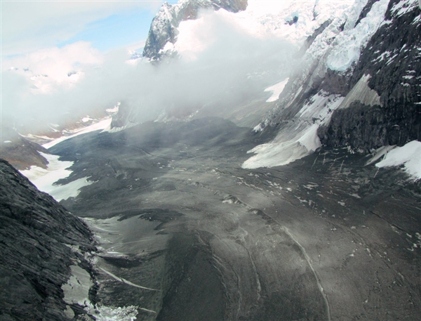
By Miguel Llanos, msnbc.com
13 July 2012 A massive landslide sent tons of rock and debris tumbling more than five miles down a glacier in Alaska, the National Park Service reported in an event that could be yet another sign of a warming world.
Located in a remote area of Glacier Bay National Park, the slide was so big it registered on earthquake monitors as a magnitude 3.4 event. Officials noticed the monitor blip on June 11 but it wasn’t until July 2 that a pilot passing over the site took photos that showed just how large it was, Glacier Bay National Park announced on its Facebook page. “It’s certainly the largest that we’re aware of” inside the park, Glacier Bay ecologist Lewis Sharman told msnbc.com. Larger landslides have happened over geologic time, Marten Geertsema, a natural hazards researcher for the Forest Service in nearby British Columbia, told msnbc.com, but it definitely was “one of the longest runout landslides on a glacier in Alaska and Canada in recent times.” […] Officials ruled out an earthquake as the trigger that caused part of the nearly 12,000-foot Lituya Mountain to give way, smothering the ice-white Johns Hopkins Glacier with dark rock and debris over an area a half-mile wide and 5.5 miles long.
Many areas of mountain permafrost have been thawing in recent decades as temperatures warm, and some experts are becoming convinced that thawing is a factor in the frequency of rock slides, Geertsema said, pointing to data by Swiss scientists studying the Alps. “It plays an important role,” Geertsema said of climate change. “I think we have been underestimating the role it might play.” Sharman, the park ecologist, echoed that sentiment, saying he’s heard from experts that “they would not be surprised” to see more such landslides inside the national park if temperatures continue to warm. “Certainly we are seeing an increase in large landslides over the past decades,” Geertsema said, citing his 2006 study that found between 1973 and 2003 the average in northern British Columbia increased from 1.3 large landslides per year to 2.3. Moreover, he said, most of the slides in northern British Columbia are happening in the warmest years. […]
5-mile-long landslide in Alaska national park; warming eyed as possible culprit