Tropics continue to assault Australia with storms
By Evan Duffey, Meteorologist
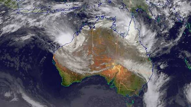
17 March 2012 Tropical Cyclone Lua (17S) made landfall today near Port Hedland in Western Australia, bringing torrential rain and damaging winds. And while Lua is now dissipating, another tropical system is developing, and already bringing impacts to land. Lua brought hurricane-force winds and torrential rains to the coast. Luckily the cyclone went onshore in a relatively lightly populated area. Much of the population of Western Australia is well to the south of where Lua made landfall. Tropical Cyclone Lua’s main impacts going forward will be from drenching rains. Flooding will be a concern across the region, with flash flooding likely in the normally bone dry Gibson and Great Sandy Deserts inland. A new threat is continuing to develop in the Gulf of Carpentaria. With low shear and warm waters to work with, a low pressure system is slowly gaining strength in the Gulf. The only inhibitor to this near stationary system is its interaction with land on nearly all sides. However, the system will most likely be named sometime of the next few days. Even if the system never develops into a tropical cyclone, it will wreak havoc on the region, nonetheless. Heavy rainfall will pound the coast of the gulf over the next few days. The system will not leave the region until late week, meaning flooding will be a concern for yet another part of the the continent.