50 doomiest images of 2011
While collecting doom-laden images for 2011, Desdemona experienced a bit of déjà vu: another year of record flooding in the Philippines, and another year of record flooding in Pakistan. The Texas drought stretched on through all of 2011, causing record agricultural losses and depopulating the center of the state. Again, record-breaking wildfires swept through North America, and Russia’s forest fires exceeded even last year’s record-breaking 1 million hectares burned. Drought and food insecurity in the Horn of Africa expanded. Climate disaster in 2011 was a re-run of 2010, only worse. 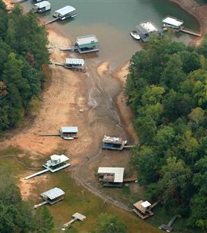 Paradoxically, world attention to these matters waned: international aid to Pakistan flood victims is a mere fraction of what’s necessary, and the Russia fires were barely noticed by news media. The year’s biggest technogenic disaster, the meltdowns at the Fukushima Daiichi nuclear plant, did get a lot of press, but by the end of 2011, coverage had fallen off greatly. Now begins the long, futile “cleanup” effort and the unglamorous wait for casualties to accrue. [Update: Looks like we didn’t have to wait for long: Fukushima: A woman speaks out about health problems – ‘Until this summer, my teeth were healthy’.] The world financial system continued to crumble, which might be viewed as another sort of slow-motion technogenic catastrophe. Desdemona is fascinated by the most visible artifacts of the peak, the uninhabited structures that were constructed out of pure speculative frenzy in China, the Persian Gulf nations, and the United States. Consider how those resources might have been usefully spent, say for moving cities away from inexorably rising seas; consider how much natural habitat might have been spared. For Desdemona, there are a few images from 2011 that are iconic: the ghostly outlines of irradiated dandelions from Fukushima; satellite views of Cyclone Yasi poised to hit the Queensland coast of Australia; the 600-year-old tsunami warning stones along the coast of Japan. Sometimes, Desdemona hopes that this blog will serve a similar function for future generations. For now, Des shares the frustration of Mansour N’Diaye, chief of cabinet at the Secretariat of the U.N. Convention to Combat Desertification:
Like everyone, we are very much moved by the image and news that we are seeing from not only Somalia, but also the whole Horn of Africa. … No one can say that we didn’t know. It was known, including by policymakers. The fact of the matter is that perhaps priorities were given to something else. And therefore, one has to face the fact that policy failures are here very much at stake.
- 2013 doomiest graphs, images and stories
- 2012 doomiest graphs, images, and stories
- 2011 doomiest graphs, images, and stories
- 2010 doomiest graphs, images, and stories
— 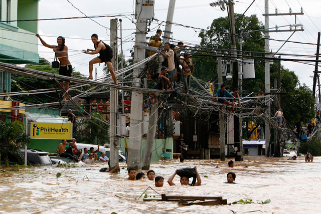 People walk on power lines above a flooded street in the Philippines, 14 January 2011. boncherry.com — Philippine flood, landslide death toll rises to 71
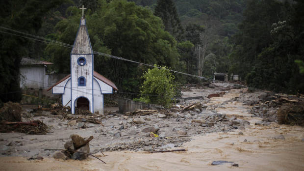
A church is surrounded by debris and floodwaters after a landslide in Teresopolis, Rio de Janeiro state. Felipe Dana / AP
Photo gallery: Flooding and mudslides in Brazil – Deadliest natural disaster in a century — 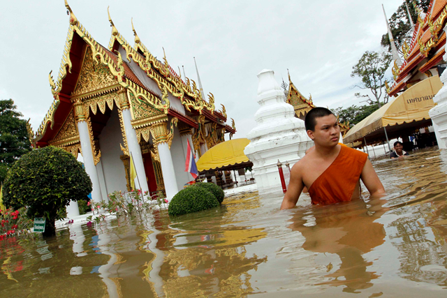
A Buddhist monk wades through waist-deep flood water near a temple in Thailand, 8 October 2011. Photo: abc.net.au United Nations officials say the capitals of Thailand and Cambodia are at risk as the worst flooding in modern times sweeps through the Mekong Basin. Kirsten Mildren, spokeswoman for the U.N.’s humanitarian affairs agency, told VOA Tuesday that officials in Bangkok are taking urgent measures as the floodwaters bear down on the city. “We’ve had four back-to-back typhoons that went through Philippines, and then that brought along heavy rain which, on top of that, the usual monsoon rain, basically has flooded the Mekong Basin. And that’s brought a whole lot of water all the way down to Thailand, Vietnam, Cambodia and Laos. And this is why you see what is being called, you know, some of the worst flooding on record in modern times.”
Record Mekong flooding threatens Bangkok, Phnom Penh — 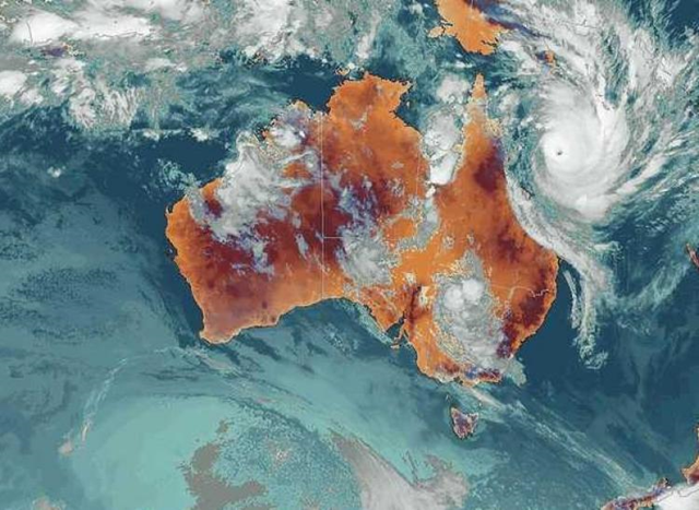
Tropical Cyclone Yasi, pictured on the upper right portion of the map, is heading toward northern Queensland. It was upgraded to a category 5 on 1 February 2011. Australia Bureau of Meteorology / theepochtimes.com Cyclone Yasi which devastated large swathes of northern Queensland has come on the heels of a raft of extreme weather conditions in Australia and around the world which scientists say will increase in frequency and intensity unless there is domestic and global action on pollution and climate change, The Climate Institute said today. “Our thoughts are with all those affected by the recent devastating cyclone but sadly Australia must prepare for more of these types of catastrophic events and ‘super storms’ as climate change drives more frequent and more intense wild weather. “While there are questions around direct links to individual weather events there is no question that the impacts of climate change is driving up the cost of living and working in Australia through warmer and wilder weather.”
Climate Institute: Cyclone Yasi reminder of climate risks and costs — 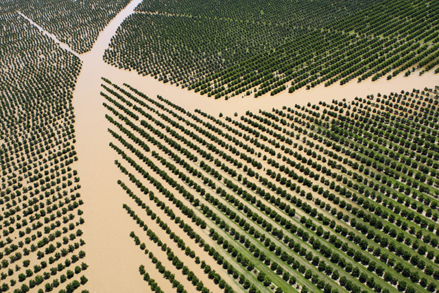
In this Tuesday, Jan. 4, 2011 photo, crops are inundated by the rising floodwaters west of Rockhampton, Australia. AP / Janie Barrett Deadly floodwaters that have swamped huge parts of Australia will cost the nation 1 billion Australian dollars ($990 million) in agricultural losses and billions more in lost coal exports, the nation’s treasurer said Friday, 28 January 2011.

Aerial view of submerged cars at the Honda car factory in Ayutthaya province, Thailand, 18 October 2011. NARONG SANGNAK / EPA Thailand’s flood disaster has been made worse by government corruption, business leaders have complained, a news report said Sunday. Thai Chamber of Commerce chairman Pongsak Assakul was quoted by the Bangkok Post as saying the flooding was one of the worst crises ever to hit the kingdom. ‘And state corruption made it worse,’ he said.
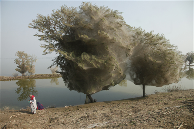
Trees cocooned in spiders webs, an unexpected side effect of the flooding in Sindh, Pakistan. By Russell Watkins / DFID – UK Department for International Development An unexpected side-effect of the flooding in parts of Pakistan has been that millions of spiders climbed up into the trees to escape the rising flood waters. Because of the scale of the flooding and the fact that the water has taken so long to recede, many trees have become cocooned in spiders webs. People in this part of Sindh have never seen this phenomenon before – but they also report that there are now less mosquitos than they would expect, given the amount of stagnant, standing water that is around.
Trees cocooned in spiders webs, an unexpected side effect of the flooding in Sindh, Pakistan — 
The storm heading toward Melbourne, after Cyclone Yasi, 6 February 2011. Nick McGrath VICTORIANS have been warned to prepare for more wild weather as flash flooding and storms wreaked havoc across the state, ripping roofs from buildings, tearing up trees and closing roads, schools and churches. Bureau of Meteorology forecaster Terry Ryan said the ”unprecedented” movement of cyclone Yasi inland to the Northern Territory, combined with a longer cloud band caused by ex-cyclone Anthony, had produced a humid and unstable air mass over Victoria. ”We’ve never seen anything like it in Australia,” he said.
Victoria swamped: Storm wreaks havoc – ‘We’ve never seen anything like it in Australia’ — 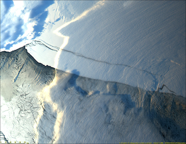
A massive iceberg, known as B-15, broke off the Ross Ice Shelf near Roosevelt Island in Antarctica in mid-March 2000. Among the largest ever observed, the B-15 iceberg is approximately 300 km long and 40 km wide an area about twice the size of the state of Delaware. The iceberg was formed from glacier ice moving off the Antarctic continent. The ice calved along pre-existing cracks in the Ross Ice Shelf. Photo: Jacques Descloitres, MODIS Land Science Team
Emergency airlift from Antarctica bases as Ross Ice Shelf breaks up — 
Early in February 1902, Captain Robert Falcon Scott sailed into McMurdo Sound and docked his ship, the Discovery, in a small, sheltered bay at the tip of a rocky peninsula on Ross Island. Eager to begin a year exploring one of Earth’s last untouched places, Scott and his men immediately set to work building a hut to serve as the base for the 47 men on the expedition. The peninsula became Hut Point Peninsula. While the men were taking scientific measurements and scouting the alien landscape, sea ice formed over McMurdo Sound, trapping the Discovery. The following summer, Scott discovered that sea ice around Hut Point Peninsula does not disappear every year. In fact, if Scott had made his expedition in 1998, he would only now be free. In 2011, sea ice in McMurdo Sound reached its lowest extent since 1998, reported the United States Antarctic Program. It is the first time that the Moderate Resolution Imaging Spectroradiometer (MODIS) sensor, which launched on NASA’s Terra satellite in late 1999, has seen the tip of Hut Point Peninsula free of ice.
Image of the Day: Retreat of Sea Ice in McMurdo Sound, Antarctica, 2003-2011 — 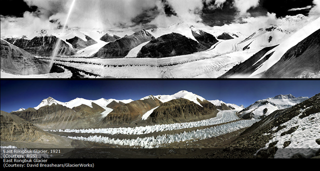
East Rongbuk Glacier, 1921 (above) and 2011 (below). Geographical Society and GlacierWorks Stunning images from high in the Himalayas – showing the extent by which many glaciers have shrunk in the past 80 years or so – have gone on display at the Royal Geographical Society in central London. Between 2007 and 2010, David Breashears retraced the steps of early photographic pioneers such as Major E O Wheeler, George Mallory and Vittorio Sella – to re-take their views of breathtaking glacial vistas.
Photo gallery: Vanishing Glaciers of the Greater Himalaya — 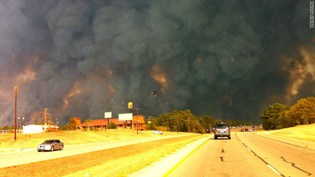
Smoke billows from a wildfire in Bastrop County, Texas, on Sunday, 5 September 2011. Wendy Moore / CNN Firefighters from across the state swarmed into Central Texas on Labor Day to combat devastating wildfires that left hundreds homeless and prompted Gov. Rick Perry to abruptly return from a scheduled East Coast political appearance. Fire-fighter and emergency rescue teams from across the state poured into the area throughout the day, many of them fresh from battling grassfires elsewhere in Texas. Capt. Dan White of the DFW Airport Fire Rescue said his team of about 20 personnel had dealt with wildfires in Palo Pinto County and the Ennis area before arriving Bastrop County at mid-day Monday. “It’s the worst thing I’ve ever seen,” White said after seeing the wall of gray and white smoke.
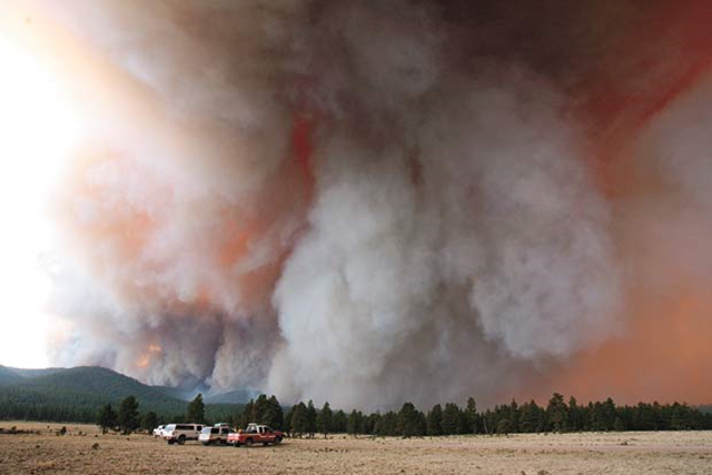
Fire crew trucks along Forest Route 24 are dwarfed by large plumes of smoke from the Wallow Fire burning in the Bear Wallow Wilderness southwest of Alpine Wednesday June 1. The 40,000 acre Wallow fire is burning 12 miles southwest of Alpine. There is no containment of the fire, which ignited Sunday, 29 May 2011. AP Photo / Arizona Daily Star, Greg Bryan
Photo gallery: Arizona wildfires, 2011 — 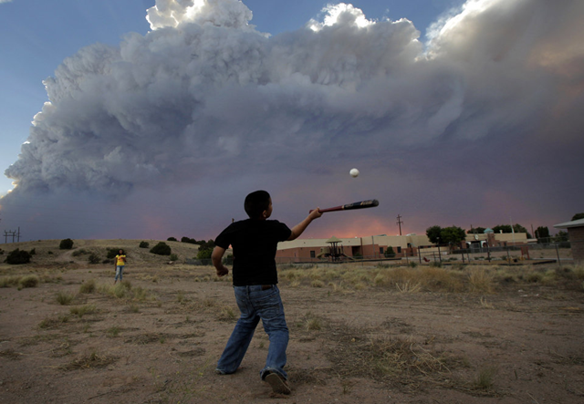
Alex Lopez, center, plays baseball with his sister Sugey while smoke generated by the Las Conchas fire covers the sky in Espanola, N.M., Wednesday, June 29, 2011. As crews fight to keep the wildfire from reaching the country’s premier nuclear-weapons laboratory and the surrounding community, scientists are busy sampling the air for chemicals and radiological materials. AP Photo / Jae C. Hong
June ties record with no rain in Prescott, Arizona; numerous fire bans in place — 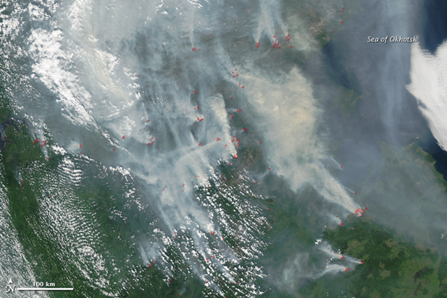
This image, taken by the Moderate Resolution Imaging Spectroradiometer (MODIS) on the Aqua satellite, shows fires burning in parts of Khabarovsk, Amur, and Sakha (Yahkutiya) on 28 July 2011. The fires are marked in red. The Russian government reported 19 large fires in this region on July 28, and RIA Novosti, a Russian news agency, reported 41 fires on July 29. NASA image courtesy Jeff Schmaltz, MODIS Rapid Response Team at NASA GSFC
Russia forests burn for second successive year, breaking last year’s record 1 million hectares — 
Aerial view of homes destroyed by a wildfire in the town of Slave Lake, Alberta, 17 May 2011. Photograph by: Ed Kaiser, Edmonton Journal Spurred by warm temperatures and gusting winds, 100 wildfires are burning in Alberta, with 23 considered out of control in a fire season unlike any seen before. “We are facing something largely unprecedented,” Colin Lloyd, executive director of the Alberta Emergency Management Agency, told reporters. “The situation overall is very dangerous.” The worst damage is concentrated in the Lesser Slave Lake region of northern Alberta, about 200 km (125 miles) north of the provincial capital of Edmonton. There, fires destroyed 40 percent of the town of Slave Lake on the weekend, forcing officials to evacuate most of the 10,000 residents of the oil, gas and forestry hub.
Oil output cut as Alberta wildfires rage – ‘We are facing something largely unprecedented’ — 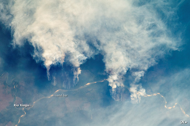
Slash-and-burn forest clearing along the Rio Xingu (Xingu River) in the state of Matto Grasso, Brazil. The photo was taken from the International Space Station on 17 September 2011. NASA/JSC
Image of the Day: Slash-and-burn fires in Amazonia viewed from orbit — 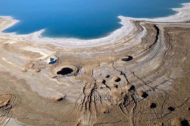
SEA IN RETREAT: The surface of the Dead Sea, already 424 meters below sea level, is falling by a meter a year. Jordanians to the east, Israelis to the west, and Syrians and Lebanese to the north are pumping so much freshwater from the Jordan River that almost none reaches the sea any more. Israel and Jordan are also siphoning water from the lake to extract valuable minerals, hastening the decline. Eitan Haddok / scientificamerican.com
Photo gallery: The Dead Sea Is Disappearing, But Could be Saved — 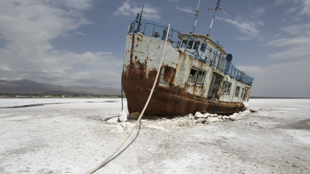
From a hillside, Kamal Saadat looked forlornly at hundreds of potential customers, knowing he could not take them for trips in his boat to enjoy a spring weekend on picturesque Oroumieh Lake, the third largest saltwater lake on earth. “Look, the boat is stuck. It cannot move anymore,” said Saadat, gesturing to where it lay encased by solidifying salt and lamenting that he could not understand why the lake was fading away. The long popular lake, home to migrating flamingos, pelicans and gulls, has shrunken by 60 per cent and could disappear entirely in just a few years, experts say — drained by drought, misguided irrigation policies, development and the damming of rivers that feed it.
Iran’s largest lake turning to salt — 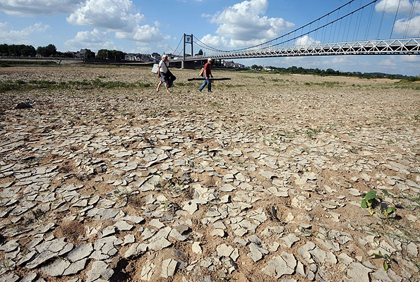
People walk across a dried riverbed in France. The spring of 2011 was France’s driest in decades and hottest in a century, drying up reservoirs and killing crops. FRANK PERRY / AFP / Getty Images
Climate of denial: Can science and the truth withstand the merchants of poison? — 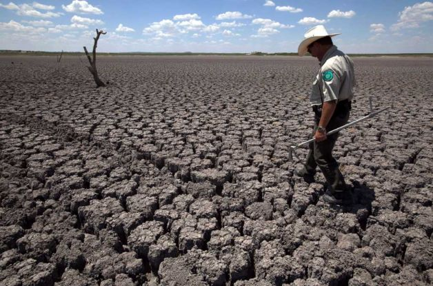
Texas State Park police officer Thomas Bigham walks across the cracked lake bed of O.C. Fisher Lake Wednesday, 3 August 2011, in San Angelo, Texas. A bacteria called Chromatiaceae has turned the 1-to-2 acres of lake water remaining the color red. A combination of the long periods of 100 plus degree days and the lack of rain in the drought-stricken region has dried up the lake that once spanned over 5400 acres. Photo: Tony Gutierrez / AP
‘Severe’ drought triggers Stage 3 water restrictions for more than 1 million in North Texas — 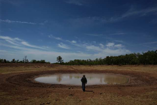
A nearly drained stock tank in West Texas, summer 2011. Genaro Molina / Los Angeles TimesWell before the contagion of wildfires was sparked in September, the state had been experiencing a weather catastrophe. Texas has seen its driest consecutive months since record-keeping began in 1895. Parts of the state have had no measurable rain in nearly a year. The drought, warn officials from the National Weather Service, may continue into next year. A brutal heat wave has tormented residents, with some cities experiencing 100-plus degree weather for more than a month. Texas Gov. Rick Perry, a GOP presidential candidate, scoffs at the notion of human-induced climate change, even suggesting recently on the campaign trail that scientists are manipulating data to make money. He also has declared a weather-related state of emergency every month since December. Meanwhile, Texas’ state climatologist has warned that his fellow citizens should get used to this new climate of extremes.
Texas wildfires: Is drought the new climate? — 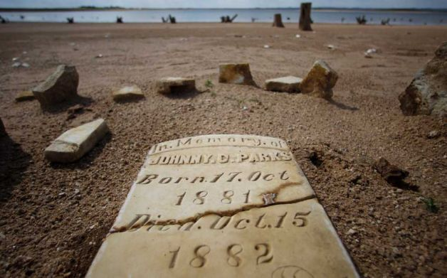
In this 5 October 2011 photo, a child’s grave site, normally at least 20 to 30 feet underwater, has joined other remnants of old Bluffton, Texas, resurfacing on the now dry, sandy lake near Bluffton, as the Texas drought shrinks the state’s largest inland lake. Eric Gay / AP
Depleted Texas lakes expose ghost towns, graves — 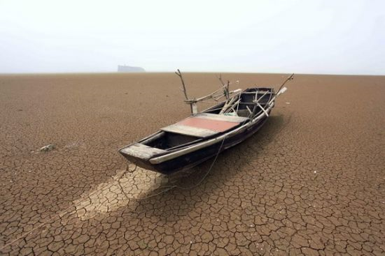
A fishing boat is stranded on the cracked bed of Poyang Lake in Jiujiang, East China’s Jiangxi province, 4 May 2011. Poyang Lake is at its lowest level in more than 50 years. The lake is drying up because of less rainfall this year and an historic drought. Xinhua Photo / Zhang JunThe monsoon rains that usually flood southern China’s middle Yangtze river in spring did not come this year, and officials say rainfall in Hubei, Jiangxi, Anhui, Jiangsu and Zhejiang is at its lowest level in more than 50 years. “Such large-scale scarcity in southern China is very serious and the scale is much larger than before,” said Zhang Ximing, a water resources specialist at the World Bank who recently returned from drought-stricken Jiangxi. While droughts are not uncommon in China, water shortages have steadily worsened during the past decade, as increased agricultural irrigation and worsening water contamination have hit supplies. China’s available water per capita is just a quarter of the world average and the lowest of any large economy, according to the World Bank.
China faces worst drought in 50 years – ‘All the rice fields have dried up’ — 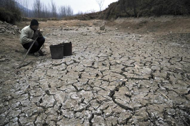
In this photo taken on 28 January 2011, a Chinese farmer smokes near a dried up pond in the village of Danuanzhang in Rizhao in eastern China’s Shandong province. Months of dry weather have given China’s key wheat-growing province of Shandong its worst drought in at least 40 years. AP
China says drought eased after snow, rain — 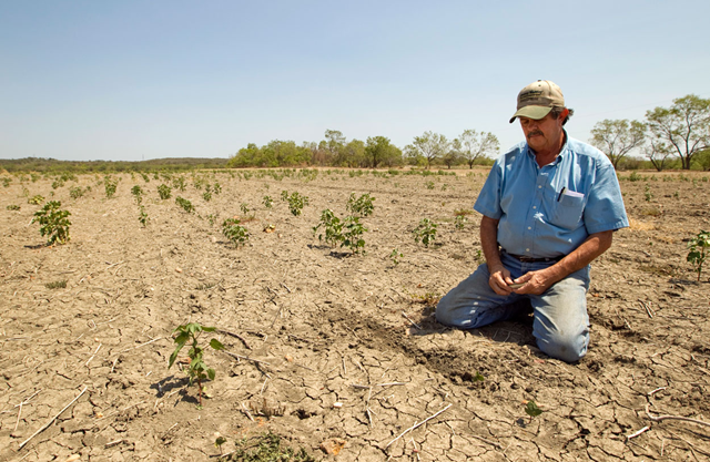
Terry Hash pauses after searching in the cracked soil for cotton seeds in his 175-acre cotton field in Garfield, Texas on 18 August 2011. Hash planted 800 acres of cotton, corn, wheat and sorghum, and almost all of it was destroyed by the drought. Despite having insurance, Hash said he worries about how he is going to pay his farm loans and borrow more money for next season’s crops. ‘Lots of sleepless nights,’ Hash said. ‘You lay in bed wondering what the hell you’re going to do.’ Jay Janner / statesman.com
In the world’s breadbasket, changing climate feeds worry — 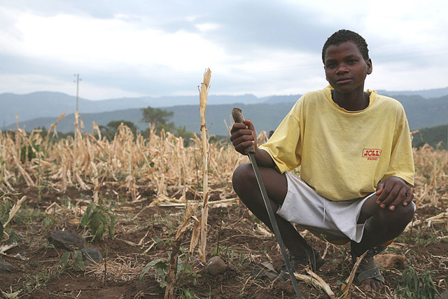
An Ethiopan boy works a field of crops that’s been withered by the 2011 drought, 21 July 2011. USAID / wikipedia.orgExperts say there was plenty of warning that the Horn of Africa was likely to experience severe drought. Nevertheless, millions of people are now at risk. Scientific experts have been saying for years that the Horn of Africa was vulnerable. The warning came with recommendations to prevent drought or lessen its effects. But to a large extent, those recommendations remained just that — recommendations. “Like everyone, we are very much moved by the image and news that we are seeing from not only Somalia, but also the whole Horn of Africa,” said Mansour N’Diaye, chief of cabinet at the Secretariat of the UNCCD – the United Nations Convention to Combat Desertification. He described what’s happening in the Horn as “an illustration of regret.” “Regret that most of the knowledge that has been accumulated over years, not only from the UNCCD, but also from other relevant international organizations, about drought and how to address the issue of drought. All those. We are unfortunate to say that they are not very much put to the attention of policymakers for them to take preventive measures. “So no one can say that we didn’t know. It was known, including by policymakers. The fact of the matter is that perhaps priorities were given to something else. And therefore, one has to face the fact that policy failures are here very much at stake,” he said.
Warnings of Africa drought came early from climate scientists – ‘No one can say that we didn’t know’ — 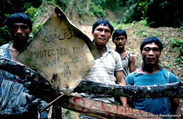
Tribespeople in Sarawak, in the Malaysian part of Borneo, blockade a road. Under Taib’s rule, the Penan have mounted countless blockades to stop their forest being destroyed. © Andy Rain / Nick Rain / SurvivalThe Sarawak, in the Malaysian part of Borneo, say the 30-year rule of Chief Minister Taib Mahmud has ‘raped’ their land, destroyed their rainforests and brought ‘hardship and suffering’. The Penan tribe have seen logging companies, licensed by Taib Mahmud’s government, devastate huge tracts of the forests they rely on. One Penan woman told Survival, ‘Our land and our river have been destroyed by the logging company, by the oil palm plantation. Everything has been destroyed – our sago, our fish, our river – all the jungle’s produce that we depend on has been destroyed. It brings hardship and suffering to our land.’
Borneo tribes: 30-year regime ‘has destroyed everything’ — 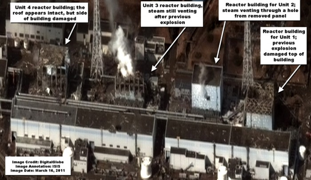
DigitalGlobe released a satellite image of the Fukushima Daiichi Nuclear site in Japan taken at 9:35AM local time on March 16, 2011. Damage to the Unit 1 reactor building from a previous explosion can still be seen. Damage to the Unit 3 reactor building from an explosion can be seen as well. Steam can still be seen emitted from the top of the damaged building. The angle of this new image, however, shows what appears to be more extensive damage to the Unit 3 reactor building than can be seen in previous satellite imagery. The image also shows damage to the reactor building for Unit 4 from an explosion. Steam can be seen venting out of a hole in the side of the reactor building for Unit 2. Workers likely removed a panel in the side of the building to vent the steam.
Image of the Day: Satellite View of Fukushima Daiichi Nuclear Site, 16 March 2011 — 
Autoradiograph of dandelion leaves from Fukushima, May 2011. From the blog of Professor Bin Mori of Tokyo University Graduate School of Agricultural and Life Sciences.Professor Mori says the pictures show that radioactive materials have been absorbed from the roots and distributed throughout the plants. He thinks the dark dots on the dandelion leaves are where the radioactive materials landed on the leaves.Professor doesn’t recommend tempura made out of these spring delicacies.
Autoradiographs of radioactive dandelion and horsetail from Fukushima — 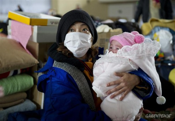
Refugees at Yonezawa Gymnasium in Japan. A mother holds her baby at Yonezawa gymnasium, which provided a shelter for 504 people who either lost their homes by the Tsunami or live near Fukushima nuclear Power Station. Greenpeace
‘Permanent relocation’ of villages around Fukushima Daiichi nuclear plant — 
A worker checks a mother and baby for radiation near Fukushima, Japan, 14 March 2011.

A large hole blasted in the south-side wall of the 4th floor of the Fukushima nuclear power plant Unit 4 building, 10 June 2011. The hole was caused by the March 15th explosion. The mangled piping is necessary to restore cooling to the spent fuel pool. TEPCO

Smoke from one of the Fukushima nuclear plant explosions billows over the sea. crawlcraft.com
26 March 2011 (Asahi Shimbun) – Fukushima No. 1 nuclear plant, crippled by the Great East Japan Earthquake of March 11, has discharged more radiation than the infamous Three Mile Island nuclear plant in the United States, according to calculations by the central government. It has already reached a level 6 serious accident on the International Nuclear and Radiological Event Scale (INES). Separately, calculations made by experts place the level of soil contamination in some locations at levels comparable to those found after the Chernobyl accident in 1986. With the Fukushima plant continuing to release radiation, there is the danger that the contaminated land will be unusable for many years.
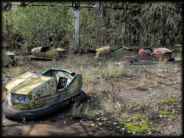
Bumper cars in Pripyat, 2011. In 2011, 25 years after the town of Pripyat was abandoned, the area surrounding Chernobyl still looks like a ghost town. Fan of TotallyCoolPix David Schindler went to Chernobyl and took these amazing photos, which will take you right back into time to 1986. David Schindler
Chernobyl study says health risks linger — 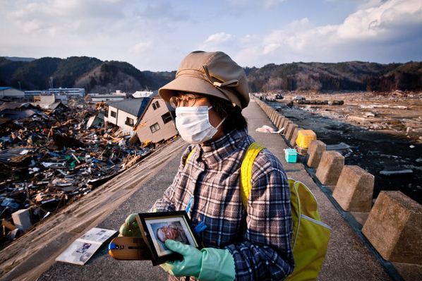
‘For us, the seawall was a source of pride, an asset, something that we believed in,’ said Eiko Araya, 58, the principal of Taro No. 3 Elementary School. Like several other tsunami survivors, Ms. Araya was walking atop the inner wall late Wednesday afternoon, peering down at the ruins of Taro. ‘We felt protected, I believe. That’s why our feeling of loss is even greater now.’ Ko Sasaki
In Japan, seawall offered a false sense of security — 
Modern sea walls failed to protect coastal towns from Japan’s destructive tsunami in March. But in the hamlet of Aneyoshi, a single centuries-old tablet saved the day. “High dwellings are the peace and harmony of our descendants,” the stone slab reads. “Remember the calamity of the great tsunamis. Do not build any homes below this point.” Hundreds of such markers dot the coastline, some more than 600 years old. Collectively they form a crude warning system for Japan, whose long coasts along major fault lines have made it a repeated target of earthquakes and tsunamis over the centuries.
Tsunami-hit towns forgot warnings from ancestors — 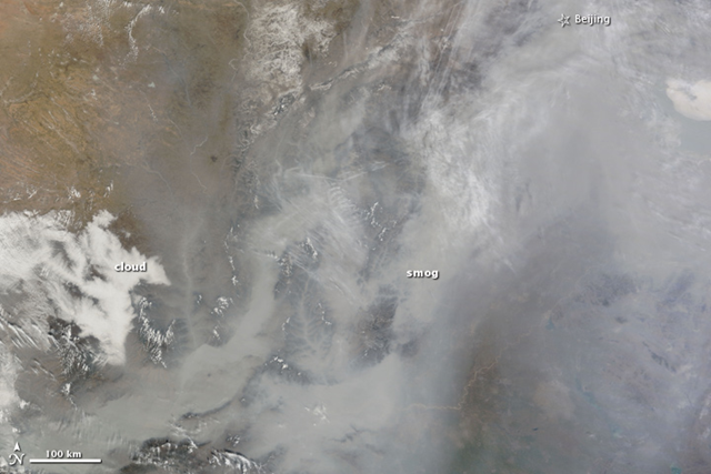
Dense smog settled over the North China Plain on 20 February 2011. The featureless gray-brown haze is so thick that the ground is not visible in parts of this photo-like image taken at 11:35 a.m. by the Moderate Resolution Imaging Spectroradiometer (MODIS) on NASA’s Terra satellite. At that time, a weather station at Beijing’s airport reported visibility of 1.9 miles (3.1 kilometers). Visibility dropped as low as 1.1 miles (1.8 km) later in the afternoon.
Image of the Day: Haze over China Viewed from Orbit, 20 February 2011 — 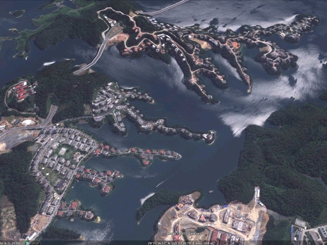
China plans to build 20 cities a year for the next 20 years. The unacknowledged problem is finding buyers for those hundreds of millions of new homes. Last year we published images of ghost cities based on a report from Forensic Asia Limited. This week we asked analyst Gillem Tulloch what has happened in the past six months. “China built more of them,” Tulloch said. “China consumes more steel, iron ore and cement per capita than any industrial nation in history. It’s all going to railways that will never make money, roads that no one drives on and cities that no one lives in.” “It’s like walking into a forest of skyscrapers, but they’re all empty,” he said of Chenggong.
Photo gallery: Satellite images of the ghost cities of China, 2011 — 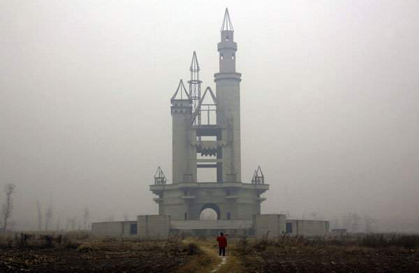
The unfinished replica of the tower at the entrance to Disneyland rises from empty fields in China’s abandoned fake Disneyland, 14 December 2011. David Gray / Reuters
China’s deserted fake Disneyland — 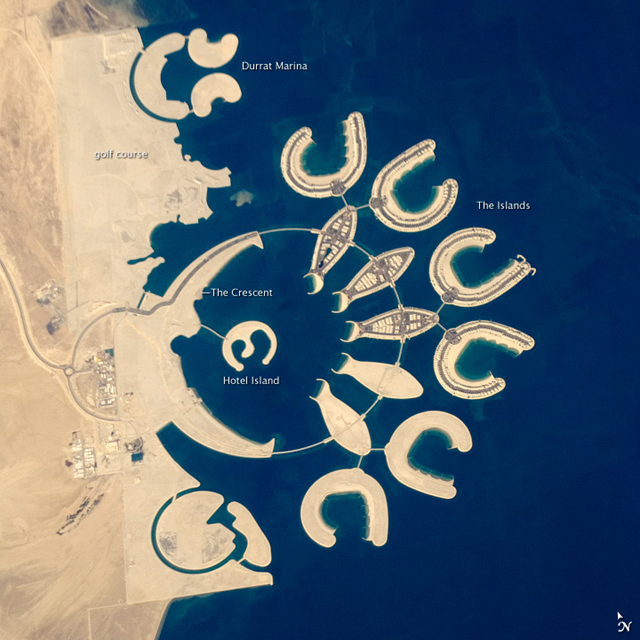
At the southern end of Bahrain Island, at the furthest point from the cities of the kingdom, a new complex of 14 artificial islands has risen out of the sea. Designed for residential living and tourism, and aimed at a cosmopolitan clientele, the Durrat Al Bahrain includes 21 square kilometers (8 square miles) of new surface area for more than 1,000 residences, luxury hotels, and shopping malls. The complex has been designed to include: The Islands (six “atolls” leading off five fish-shaped “petals”), The Crescent, Hotel Island, and Durrat Marina in the north.
Image of the Day: The 14 Artificial Islands of Durrat Al Bahrain Viewed from Orbit — 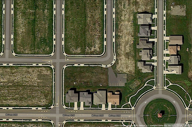
Satellite view of an abandoned housing development in Rio Vista, California, 2011. google.com In 2008, Zimbio hosted a nice photo gallery named “Town Of Rio Vista Nears Bankruptcy, As Foreclosure Crisis Spreads,” which introduced us to a development in Rio Vista, California. Only a handful of the planned 750 homes were built before the global financial bubble burst. Construction halted on November 20, 2008. Desdemona has seen the revival of a few apparently doomed developments in the Seattle area, so it seemed plausible that the Rio Vista development might have received an infusion of new capital. But as these satellite images from 2010 and 2011 show, it hasn’t happened.
Photo gallery: Abandoned Rio Vista housing development in 2008, 2010, and 2011 — 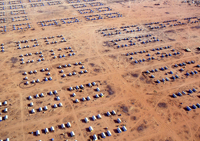
Dadaab refugee camps in Kenya, March 2011. The world’s biggest refugee complex, set up at the start of Somalia’s civil war in 1991, now also counts Sudanese and Ethiopians among its population of more than 300,000. T Bolstad / UNHCRWhile the people of East Africa are accustomed to drought periods, the current and long-lasting drought is unusual. A study this year in Climate Dynamics found that dry conditions in East Africa would likely continue due to climate change. “Global temperatures are predicted to continue increasing, and we anticipate that average precipitation totals in Kenya and Ethiopia will continue decreasing or remain below the historical average,” said USGS scientist Chris Funk. “The decreased rainfall in eastern Africa is most pronounced in the March to June season, when substantial rainfall usually occurs. Although drought is one reason for food shortages, it is exacerbated by stagnating agricultural development and continued population growth.”
Worst drought in 60 years brings starvation fears to East Africa — 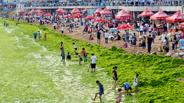
Massive green algae bloom and tourists on the beach in Qingdao, China, 25 July 2011. The green algae threatens marine life as it sucks oxygen from the water. CNNAlmost 200 square miles (500 square kilometers) of the Yellow Sea off China are covered by a massive bloom of green algae, according to a report from China’s Xinhua news service. The bloom has spread to almost 7,400 square miles (19,050 square kilometers) in total and is expected to grow, Xinhua reported, citing the North China Sea Marine Forecasting Center of State Oceanic Administration. Tons of the green algae had to be removed in 2008 to make way for sailing events at the Summer Olympics.
Massive algae bloom covers Yellow Sea — 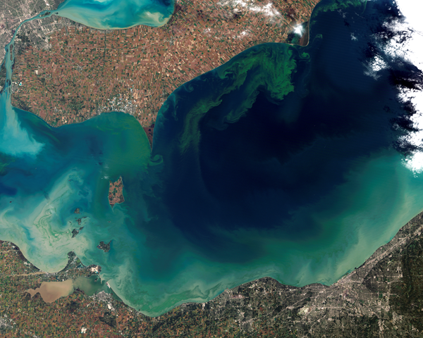
The green scum shown in this image is the worst algae bloom Lake Erie has experienced in decades. The Landsat-5 satellite acquired the top image on October 5, 2011. Vibrant green filaments extend out from the northern shore. The bloom is primarily microcystis aeruginosa, an algae that is toxic to mammals. Landsat image created for NASA’s Earth Observatory by Jesse Allen and Robert Simmon, using data provided courtesy of USGS. MODIS Rapid Response imagery provided courtesy of Jeff SchamltzThe green scum shown in this image is the worst algae bloom Lake Erie has experienced in decades. Such blooms were common in the lake’s shallow western basin in the 1950s and 60s. Phosphorus from farms, sewage, and industry fertilized the waters so that huge algae blooms developed year after year. The blooms subsided a bit starting in the 1970s, when regulations and improvements in agriculture and sewage treatment limited the amount of phosphorus that reached the lake. But in 2011, a giant bloom spread across the western basin once again. The reasons for the bloom are complex, but may be related to a rainy spring and invasive mussels.
Image of the Day: Satellite View of Toxic Algae Bloom in Lake Erie — 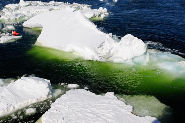
The emerald green waters of a polynya algae bloom in Antarctic sea ice. David Munroe, USAP / nationalgeographic.com “Crazy green” pools teeming with life have been found among remote Antarctic sea ice, scientists say—and they may be a global warming boon. Observed in the little-studied Amundsen Sea (see map), the brilliant blooms owe their colors to chlorophyll, a pigment in various types of phytoplankton, or tiny algae. Algae-eating zooplankton, small crustaceans called krill, and fish and shrimp larvae also thrive in the area. A recent scientific expedition studied the blooms while plying the Amundsen Sea’s polynya, a region of seasonally open water surrounded by sea ice. Such a discovery “exceeds all expectations,” wrote Patricia Yager, chief scientist for the Amundsen Sea Polynya International Research Expedition (ASPIRE), in a preliminary research report. It’s “the greenest water I’ve seen in the world,” she said. It’s not unusual to find high amounts of chlorophyll in the Amundsen Sea, according to Maria Vernet, a research biologist at Scripps Institution of Oceanography in La Jolla, California. That’s because polynyas’ waters are regularly infused with fresh water from melting sea ice, and they receive plentiful sunlight—both fruitful conditions for life. For instance, algae often thrive in freshwater “lenses”—layers of fresh water up to 130 feet (40 meters) deep that sometimes sit on top of denser seawater. But “seeing something more than 30 [micrograms of chlorophyll] is exceptional, and seeing something more than 40 is very exceptional,” said Vernet, who was not involved in the expedition. “I’ve only seen it a few times.”
‘Crazy green’ algae pools seen in Antarctic Sea — 
The debris from the stomach of a green sea turtle. Hundreds of shards reveal the threat to wildlife from debris floating in our seas. independent.co.uk Humans currently produce 260 million tons of plastic a year. When those products are pulled into the sea’s currents, the plastics do not biodegrade but are broken into smaller pieces which are consumed by marine life at the bottom of the food chain. An examination of gastrointestinal obstruction in a green turtle found off Florida discovered that, over the course of a month, the animal’s faeces had contained 74 foreign objects, including “four types of latex balloons, different types of hard plastic, a piece of carpet-like material and two 2-4mm tar balls.”
Image of the Day: The plastic found in a single turtle’s stomach — 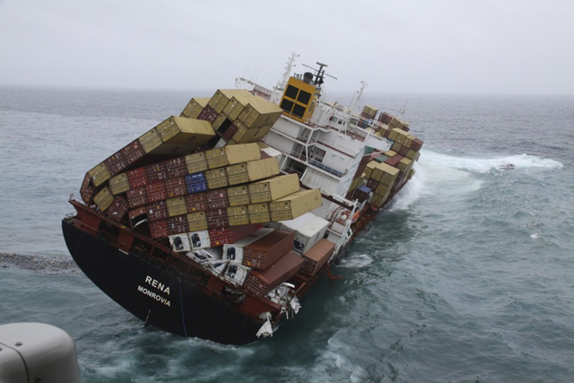
The 47,230 tonne Costamare-owned MV Rena lists in heavy swells, about 12 nautical miles (22 km) from Tauranga, on the east coast of New Zealand’s North Island, 12 October 2011, a week after hitting the Astrolabe Reef. ReutersEnvironment Minister Nick Smith said the situation was going to get “significantly worse” in coming days. “This event has come to a stage where it is New Zealand’s most significant maritime environmental disaster,” he told a news briefing in Tauranga.
MV Rena update: Cargo vessel remains intact in bad weather – Fresh charges filed against Filipino captain; Oil spill is New Zealand’s ‘worst maritime environmental disaster’ — 
An endangered black rhino is airlifted to safety from poachers. The seventh black rhino population established by the WWF Black Rhino Range Expansion Project, was recently released after an epic 1500 kilometer trip across the country. 19 of the critically endangered animals were moved from the Eastern Cape to a new location in Limpopo province. Green Renaissance / www.greenrenaissance.co.za
Critically endangered black rhinos airlifted to safety from poachers — 
Stomata are structures that allow plants to exchange gases with the air. Contemporary plants in Florida (right) have fewer stomata than their ancestors did a few decades ago. Credit: Emmy LammertsmaAs carbon dioxide levels have risen during the last 150 years, the density of pores that allow plants to breathe has dwindled by 34 percent, restricting the amount of water vapor the plants release to the atmosphere, report scientists from Indiana University Bloomington and Utrecht University in the Netherlands in an upcoming issue of the Proceedings of the National Academy of Sciences. [cf. Huge parts of world are drying up: Land evapotranspiration taking unexpected turn]
Rising carbon dioxide is causing plants to have fewer pores, reducing transpiration
I had not seen the radiographic leaf print from Fukishima.
That is something that anyone can do. A very easy test for radiation.
great post Desdemona. My God, it's hard to get your head around sometimes isn't it?
thanks for all you do to keep these issues out there.
pamela