Graph of the Day: Deepwater Channel Beneath Pine Island Glacier, 2009
Caption by Kathryn Hansen and Michael Carlowicz
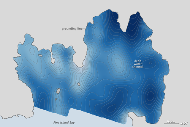
January 19, 2011 In October 2009, a series of flights over Antarctica led to the discovery of a hidden feature beneath a floating ice shelf. Scientists participating in NASA’s Operation IceBridge mapped the water depth and seafloor topography beneath Pine Island Glacier and found a deepwater channel—a likely pathway for warm water to reach the glacier’s underbelly and melt it from below. This image shows the topography—the height and depth of the ocean floor—beneath Pine Island Glacier. The deepest regions (navy blue) descend about 1,200 meters (3,900 feet) below sea level, while elevated seamounts and shoals (pale blue to white) are mostly 200 meters (650 feet) below sea level. … The newly discovered channel might help explain a lot of recent changes to the glacier, which drains more than 79 cubic kilometers (19 cubic miles) of ice per year from the West Antarctic Ice Sheet. Warm, deep-ocean water has a clear path through the channel, where it can penetrate to the grounding line and weaken the ice shelf. It’s unclear how or when the channel formed, or how many other ice shelves have similar features lurking below. But the new map should help scientists make better predictions about ice dynamics and how melting ice might contribute to sea level rise.
Most all our changes ahead will be gradual and imperceptibly incremental. Pine Island Glacier is one of the few dynamic AGW catastrophic events that will be breaking loose… and fairly soon