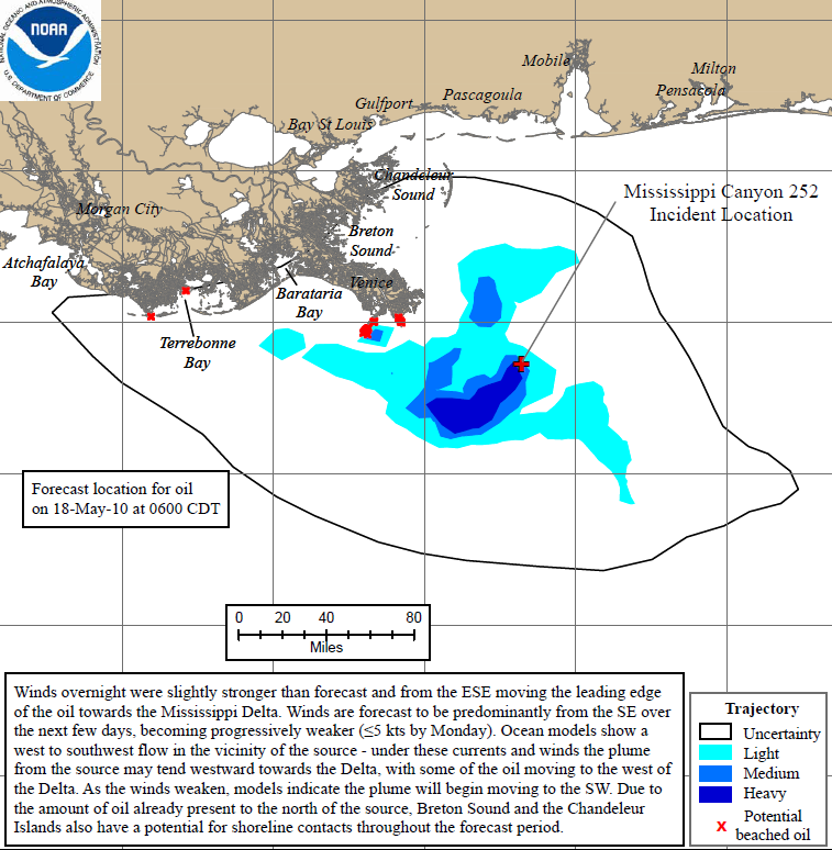
Graph of the Day: Projected Oil Spill Path to 18 May 2010
NOAA continues to provide scientific support including: modeling the trajectory and location of the oil, getting pre-impact shoreline samples surveys and baseline measurements, and planning for open water and shoreline remediation. NOAA’s National Centers for Coastal Ocean Science and NOAA Fisheries Southeast Fisheries Science Center are conducting bottlenose dolphin studies in Mississippi and Louisiana. The samples will be used to evaluate baseline levels of exposure to oil and other environmental contaminants. The team is working near Grand Isle, La., and in Mississippi Sound. The NOAA Research funded cruise of the R/V Pelican is back at the spill site with six scientists from National Institute for Undersea Science and Technology. Scientists are currently engaged in two efforts to learn more about subsurface oil. NOAA Shoreline Cleanup and Assessment Teams (SCAT) surveyed 19 miles of Dauphin Island, Ala., and the Jackson County shoreline with minimal tarball findings. An additional five teams were deployed to Bon Secour National Wildlife Refuge (Ala.) to recover tarballs. NOAA also flew missions for marine mammal surveys, coastal photography and mapping purposes. Today NOAA Modified Commercial and Recreational Fishing Closure in the Oil-Affected Portions of the Gulf of Mexico — All commercial and recreational fishing including catch and release is prohibited in the closed area; however, transit through the area is allowed.

Planetresource.net has a Eco friendly solution to clean up the tragedy British Petroleum has created, please watch the video animation:
http://www.youtube.com/watch?v=60bdQQQ3iVw and pass this along to as many people as you know.
One person can still make a difference in this world, is that simple interactions have a rippling effect. Each time this gets pass along, the hope in cleaning our planet is passed on.