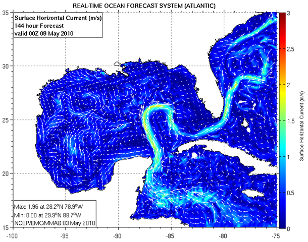
Graph of the Day: Projected Gulf Loop Current, Today + 144 Hours
This is a map of the magnitude of the horizontal velocity of the seawater at the indicated depth. Units are meters per second. RTOFS (Atlantic) is a basin-scale ocean forecast system based on the HYbrid Coordinate Ocean Model (HYCOM). RTOFS (Atlantic) is described in the following paper (PDF): “A Real Time Ocean Forecast System for the North Atlantic Ocean” by Mehra and Riven, Terr. Atmos. Ocean. Sci., Vol. 21, No. 1, 211-228, February 2010 The model is run once a day, completing at about 1400Z. Each run starts with a 24 hour assimiliation hindcast and produces ocean surface forecasts every hour and full volume forecasts every 24 hours from the 0000Z nowcast out to 120 hours. RTOFS (Atlantic) model data is available after 1400 UTC (9 AM EST).
Nowcast/Forecast graphics are updated around 1600 UTC (11 AM EST).
Atlantic Real-Time Ocean Forecast System (RTOFS) Graphic Nowcasts/Forecasts

Hey, your blog is great! What a pleasure to see our gruesome reality so unflinchingly enblogged! Cheers!
http://www.justseeds.org/artists/roger_peet/
Thanks, I try to keep it fresh.
Love your art!