Image of the Day: Record Low Rio Negro Viewed from Orbit
Rio Negro, 9 December 2008 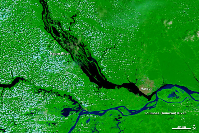 Rio Negro, 10 December 2010
By Holli Riebeek
December 11, 2010 Widespread, severe drought gripped much of the Amazon Basin in 2010, straining the network of water that makes up the Amazon River. By December 3, one of the Amazon’s largest tributaries, the Negro River, reached a record-low 13.63 meters at the port in Manaus. These images, taken by the Moderate Resolution Imaging Spectroradiometer (MODIS) on NASA’s Terra satellite, illustrate the extent of the change in the river system. The top image is from December 9, 2008, while the lower image was taken on December 10, 2010. The images include both infrared and visible light in a combination that highlights the presence of water of the ground. Clear water is black, while sediment-laden water, such as the Amazon River, is dark blue. Clouds are pale blue and plant-covered land is green. The city of Manaus is light tan. The Negro River is significantly smaller in 2010 than in 2008. The most notable difference is in the braided channels northwest of Manaus. Many of the channels disappeared in 2010, and all are shrunken. The main body of the river near Manaus is narrower. Every body of water in the scene, including the Amazon River, also changed. Tan islands dot the Amazon where water had been in 2008. According to news reports, the drop in the water level stranded villages that rely on the rivers for transportation and caused food and water shortages. The record low at the Negro River comes just 16 months after the river set a record high of 29.77 meters, flooding Manaus. The 2010 drought occurred on the heels of a similar “once-in-a-century” drought in 2005. In both cases, the dry weather was connected to water temperatures in the tropical Atlantic Ocean, which were much warmer than normal through most of 2010. The warm water altered weather patterns, pulling rain to the north and keeping the Amazon dry. Low humidity and high temperatures accompanied the drought, leading to extensive fires and poor air quality.
Brazil’s Negro River Reaches Record Low