Arctic sea ice at record low for July
Contact NSIDC User Services or call +1 303.492.6199
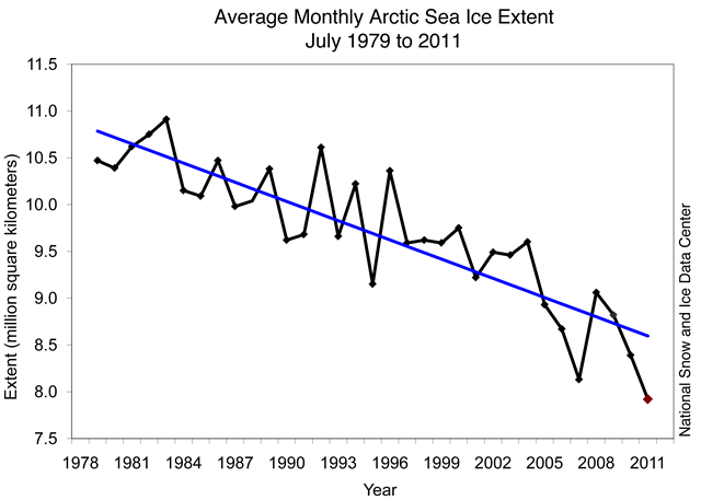
3 August 2011 Arctic sea ice extent averaged for July 2011 reached the lowest level for the month in the 1979 to 2011 satellite record, even though the pace of ice loss slowed substantially during the last two weeks of July. Shipping routes in the Arctic have less ice than usual for this time of year, and new data indicate that more of the Arctic’s store of its oldest ice disappeared. Average ice extent for July 2011 was 7.92 million square kilometers (3.06 million square miles). This is 210,000 square kilometers (81,000 square miles) below the previous record low for the month, set in July 2007, and 2.18 million square kilometers (842,000 square miles) below the average for 1979 to 2000. On July 31, 2011 Arctic sea ice extent was 6.79 million square kilometers (2.62 million square miles). This was slightly higher than the previous record low for the same day of the year, set in 2007. Sea ice coverage remained below normal everywhere except the East Greenland Sea. During the first half of July, Arctic sea ice extent declined at a relatively fast pace (see July 18 post). But ice loss slowed substantially over the latter half of the month as the weather changed. Through July, sea ice declined at an average pace of 90,200 square kilometers (34,800 square miles) per day, which is slightly faster than the average for 1979 to 2000 of 84,400 square kilometers (32,600 square miles) per day. Ice loss slowed towards the end of July as a high-pressure cell centered over the northern Beaufort Sea broke down and a series of low-pressure systems moved over the central Arctic Ocean. This change brought cooler conditions and likely pushed the ice apart into a thinner but more extensive ice cover. […]