Oil and Nature: A Landscape Reconfigured
By EMMA BRYCE
25 September 2012 In the stark white space of the Aperture Gallery in Chelsea, billboard-size photographs present an array of haunting scenes. A chemical plant with a cemetery in the foreground. An empty basketball court alongside a turreted oil refinery. A lush swamp filled with trees, one of which has a Shell Oil sign nailed to it. The exhibition, “Petrochemical America,” and an accompanying book of the same title are the product of a collaboration between the photographer Richard Misrach and the landscape architect Kate Orff, an assistant professor at Columbia University’s Graduate School of Architecture, Planning and Preservation. Together, they chronicle the history and the environmental and social impacts of the petrochemical industry in the Mississippi River Corridor in Louisiana, between Baton Rouge and New Orleans. Louisiana has the highest density of oil and gas operations in the Western Hemisphere, partly as a result of tax policies favorable to the industry, Mr. Misrach and Ms. Orff show. Many of them are clustered in economically disadvantaged areas. With Mr. Misrach’s photographs and Ms. Orff’s throughlines – explanatory displays that collate data, maps and images to tell a story – the two make the case that petrochemicals have irrevocably shaped the region and the nation and are deeply embedded in American culture. “No where else in the world is there such a juxtaposition of everyday life and the enormous scale of this industry,” Ms. Orff said in an interview.
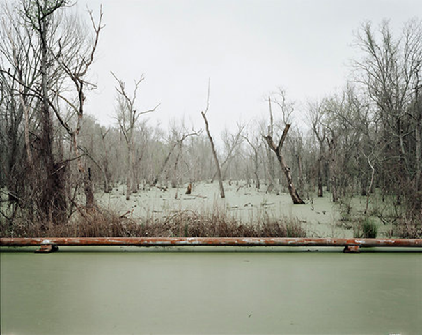
While oil refineries dot the the banks of the Mississippi in the corridor — known to some as Cancer Alley — the bulk of the industry revolves around chemical plants that feed off the network of pipes funneling gas and oil from the Gulf of Mexico. Since the 1930’s, one photo caption explains, roughly 26,000 miles of pipeline have been threaded through southern coastal wetlands. (Roughly 40 percent of the nation’s wetlands lie in Louisiana.) This intermingling of nature and industry is a theme that wends its way through the show. A man fishes at nighttime as a gargantuan light-spangled oil tanker drifts by; plants flourish along the river’s banks as a refinery looms in the background. Between the photographs, Ms. Orff presents explanatory markers about oil reserves in the gulf, the spread of oil rigs and pipelines and how gas is refined into isolated chemicals. “I think Americans think oil and gasoline is what we put in our gas tanks,” she said. “But a huge part of the picture” is “disposable waste.” Her throughlines also delve into social impacts like the displacement of poorer communities as the petrochemical industry advanced through the region. Inhabitants of towns with forgotten names — Reveilletown, Sunrise, Morrisonville — were relocated either as industries moved in or as environmental contamination intensified. […]