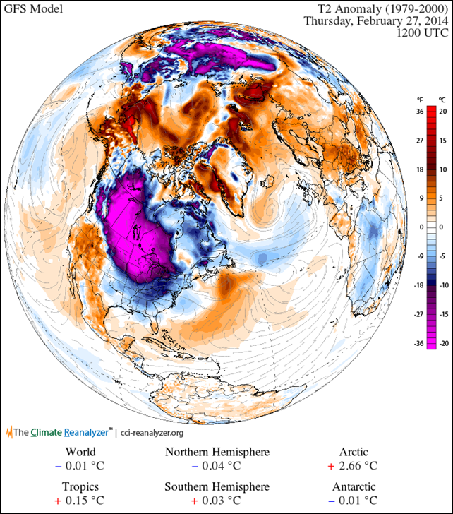
Graph of the Day: Northern Hemisphere temperature anomaly map forecast for 27 February 2014
20 February 2014
By Sean Birkel (climatereanalyzer.org) – Today’s 7-day forecast from the GFS model shows another sizable bubble of cold air that will develop and waft down from the Arctic over the North American middle latitudes (Figure 1). Relatively warm air will invade the Arctic in its place. At first glance, it appears this latest cold-air outbreak could rival that of early January. Another attack of the Polar Vortex, I suppose. Bear in mind that a polar vortex is the circulation of air at upper levels over the polar regions. The term has been in meteorological and atmospheric science literature for several decades. As meteorologist Stu Ostro of The Weather Channel explains in detail, there has been a bit of confusion in the media about the physical meaning of a polar vortex. One might instead prefer to call these events cold waves, because they result most directly from deep troughs (equatorward long waves) in the jet stream. Climate implications? Cold waves, and the opposite, heat waves, form out of natural weather variability. However, as the climate system seeks equilibrium with ever-changing boundary conditions (e.g., rise in greenhouse gases, stratospheric ozone depletion, deforestation, solar changes), seasonal atmospheric circulation patterns will continue to evolve. This complex relationship is highlighted in a recent study that articulates how the dramatic decline of Arctic sea ice over the past three decades (Figure 2) appears to be driving a slowdown of the Northern Hemisphere westerlies (i.e., jet stream). We know from satellite measurements and from a vast array of long-term station data that the Arctic is warming at rapid pace, much more quickly than anywhere else (e.g., Figure 3). This means that the equator-pole thermal gradient is decreasing, and in turn slowing down the westerly winds. A slow jet stream has longer waves than a fast one, bringing greater likelihood for the development of atmospheric blocking patterns. A striking example of this new circulation regime is the Summer-In-March event of 2012 when a particularly intense ridge of warm, moist air developed over the central and eastern U.S. leading to century-old high temperature records being shattered by as much as 20 °F. In contrast, the much-hyped “polar vortex” event of last January is comparable to cold-air outbreaks typical of the 1980s and 1990s. [more]
