New data show annual rate of deforestation in Brazilian Amazon is up for first time in five years
By Amel Ahmed
11 September 2014 (Al Jazeera) – The rate of destruction blighting the world’s largest rain forest spiked by nearly a third last year, according to new data released by the Brazilian government. Satellite data showed that 2,315 square miles of forest had been cleared from the Brazilian Amazon in the 12 months through July 2013, up 29 percent from the previous year. It reflects a reversal in the downward trend since 2009. Despite the increased destruction in 2013, the Brazilian report showed that the area cleared is still the second-lowest annual figure since the government began tracking deforestation in 2004. In that year, almost 11,580 square miles of forest were lost. Still, an estimated 17 percent of the Amazon has been lost in the last 50 years, mostly because of forest conversion for cattle ranching — a trend that has concerned environmentalists, given that it is home to an estimated quarter of all known land species. The Amazon also serves as a giant carbon sink, helping stabilize the planet’s climate. Aside from agricultural expansion, factors driving the rise in deforestation include illegal logging and the invasion of public lands adjacent to big infrastructure projects, such as roads and hydroelectric dams, according to World Wide Fund for Nature (WWF). According to the government report, the states of Pará and Mato Grosso — where most of Brazil’s agricultural expansion is taking place — showed the greatest increases in deforestation. More than 390 square miles have been cleared in those states. Curbing deforestation worldwide is an integral part of reducing climate change because deforestation accounts for 15 percent of all annual greenhouse gas emissions, according to WWF. Globally, forests are depleted by up to 58,000 square miles every year — equivalent to 36 football fields every minute, according to the WWF. As well as the cost to curbing climate change, deforestation threatens a wide range of plant and animal species.
Destruction of Brazilian Amazon spikes by almost a third
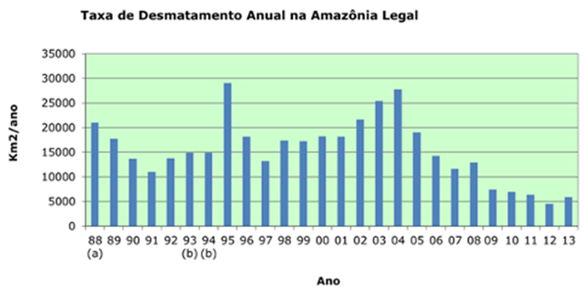
15 September 2014 (INPE) – [Translation by Bing] The National Institute for space research (INPE) has completed the mapping and calculating the rate of deforestation in the Legal Amazon for the period August/July 2012/2013, activities carried out under the Project of monitoring the deforestation in the Legal Amazon (PRODES). The final result of the study showed a rate of 5,891 km2/year. This value represents the second lowest rate of deforestation recorded in Legal Amazon since INPE began to measure it, in 1988. The PRODES computes how deforestation areas larger than 6.25 hectares where complete removal of forest cover – the clear cut. The value of the consolidated rate, obtained after the mapping of the American satellite Landsat scenes 216 8/OLI, is approximately 1% higher than estimated by the INPE in December 2013, which was of 5,843 km2, calculation generated based on satellite images of the same 86 and that covered the area in which they were registered more than 90% of deforestation in the previous period (August/July 2011/2012) and also the 43 municipalities referred to in Federal Decree 6,321/2007 and updated in 2009. The current result points exist effectiveness in combating deforestation, particularly from the creation, in 2004, the plan of action for the prevention and Control of deforestation in the Legal Amazon (PPCDAm over), coordinated by the Ministry of environment and the Civil House of the Presidency of the Republic, with a 79% reduction since 2004, as shown in the following historic series. The table below presents the distribution of the rate of deforestation in the States that comprise the Legal Amazon:
| ESTADO | DESMATAMENTO (KM2) |
| ACRE | 221 |
| AMAZONAS | 583 |
| AMAPÁ | 23 |
| MARANHÃO | 403 |
| MATO GROSSO | 1139 |
| PARÁ | 2346 |
| RONDÔNIA | 932 |
| RORAIMA | 170 |
| TOCANTINS | 74 |
| AMAZÔNIA LEGAL | 5891 |
INPE divulga resultado final do PRODES 2013
