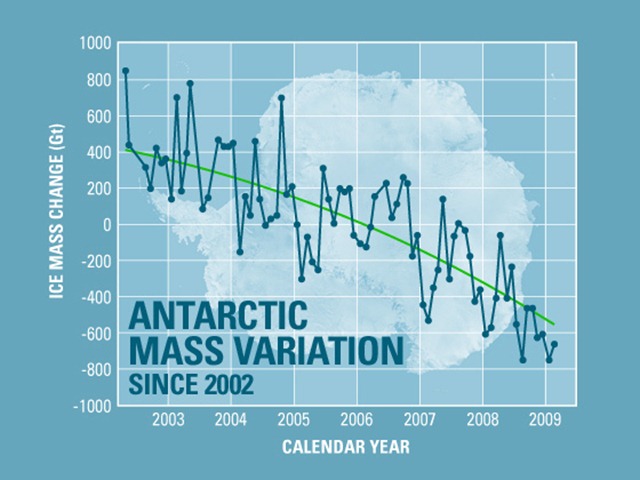
Graph of the Day: Antarctic Ice Mass Loss, 2002-2009
The continent of Antarctica has been losing more than 100 cubic kilometers (24 cubic miles) of ice per year since 2002. Measurements from the Grace satellites confirm that Antarctica is losing mass 11. Isabella Velicogna of JPL and the University of California, Irvine, uses Grace data to weigh the Antarctic ice sheet from space. Her work shows that the ice sheet is not only losing mass, but it is losing mass at an accelerating rate. “The important message is that it is not a linear trend. A linear trend means you have the same mass loss every year. The fact that it’s above linear, this is the important idea, that ice loss is increasing with time,” she says. And she points out that it isn’t just the Grace data that show accelerating loss; the radar data do, too. “It isn’t just one type of measurement. It’s a series of independent measurements that are giving the same results, which makes it more robust.”

how about this as graph of the day?
http://twitpic.com/y290d/full
from the California State Parks system (as forwarded by RPauli):
> >
> >ALERT:
> >***
> >Update
> >Currently, the strong El Nino is reaching its peak in the Eastern
Pacific, and now finally appears to be exerting an influence on our
weather. The strong jet has been apparent for quite some time out over
the open water, but the persistent block had prevented it from reaching
the coast. Now that the block has dissolved completely, a 200+ kt [this
means approximately 230 miles per hour] jet is barreling towards us.
Multiple large and powerful storm systems are expected to slam into CA
from the west and northwest over the coming two weeks, all riding this
extremely powerful jet stream directly into the state.
> >
> >The jet will itself provide tremendous dynamic lift, in addition to
directing numerous disturbances right at the state and supplying them
with an ample oceanic moisture source. The jet will be at quite a low
latitude over much of the Pacific, so these storms will be quite cold,
at least initially. Very heavy rainfall and strong to potentially very
strong winds will impact the lower elevations beginning late Sunday and
continuing through at least the following Sunday.. This will be the case
for the entire state, from (and south of) the Mexican border all the way
up to Oregon. Above 3000-4000 feet, precipitation will be all snow, and
since temperatures will be unusually cold for a precipitation event of
this magnitude, a truly prodigious amount of snowfall is likely to occur
in the mountains, possibly measured in the tens of feet in the Sierra
after it’s all said and done.
> >
> >But there’s a big and rather threatening caveat to that (discussed
below).Individual storm events are going to be hard to time for at least
few more days, since this jet is just about as powerful as they come (on
this planet, anyway). Between this Sunday and the following Sunday, I
expect categorical statewide rainfall totals in excess of 3-4 inches.
That is likely to be a huge underestimate for most areas. Much of NorCal
is likely to see 5-10 inches in the lowlands, with 10-20 inches in
orographically-favored areas. Most of SoCal will see 3-6 inches at lower
elevations, with perhaps triple that amount in favored areas.
here's the rest that wouldn't fit:
This is where things get even more interesting, though. The models
are virtually unanimous in “reloading” the powerful jet stream and
forming an additional persistent kink 2000-3000 miles to our southwest
after next Sunday. This is a truly ominous pattern, because it implies
the potential for a strong Pineapple-type connection to develop. Indeed,
the 12z GFS now shows copious warm rains falling between days 12 and 16
across the entire state. Normally, such as scenario out beyond day seven
would be dubious at best. Since the models are in such truly remarkable
agreement, however, and because of the extremely high potential impact
of such an event, it’s worth mentioning now. Since there will be a
massive volume of freshly-fallen snow (even at relatively low elevations
between 3000-5000 feet), even a moderately warm storm event would cause
very serious flooding. This situation will have to monitored closely.
Even if the tropical connection does not develop, expected rains in the
coming 7-10 days will likely be sufficient to cause flooding in and of
themselves (even in spite of dry antecedent conditions).
> >
> >In addition to very heavy precipitation, powerful winds may result
from very steep pressure gradients associated with the large and deep
low pressure centers expected to begin approaching the coast by early
next week. Though it’s not clear at the moment just how powerful these
winds may be, there is certainly the potential for a widespread damaging
wind event at some point, and the high Sierra peaks are likely to see
gusts in the 100-200 mph range (since the 200kt jet at 200-300 mb will
essentially run directly into the mountains at some point). The details
of this will have to be hashed out as the event(s) draw closer.
> >
> >In short, the next 2-3 weeks (at least) are likely to be more active
across California than any other 2-3 week period in recent memory. The
potential exists for a dangerous flood scenario to arise at some point
during this interval, especially with the possibility of a heavy
rain-on-snow event during late week 2. In some parts of Southern
California, a whole season’s worth of rain could fall over the course of
5-10 days. This is likely to be a rather memorable event. Stay tuned.
> >***