How record-breaking Hurricane Beryl is a sign of a warming world – “What makes Beryl particularly notable is that it intensified the fastest from a tropical depression to a hurricane of any Atlantic hurricane in June or early July”
By Mark Poynting
4 July 2024
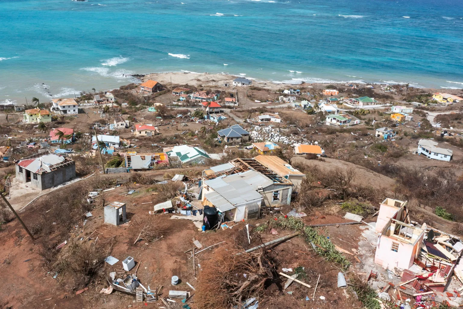
(BBC News) – Hurricane Beryl is wreaking havoc in parts of the Caribbean – and putting the role of climate change under the spotlight.
With maximum sustained wind speeds of more than 160mph (257km/h), it became the earliest category five Atlantic hurricane in records going back around 100 years.
In fact, there has only been one previous recorded case of a category five Atlantic hurricane in July – Hurricane Emily, on 16 July 2005.
The causes of individual storms are complex, making it difficult to fully attribute specific cases to climate change.
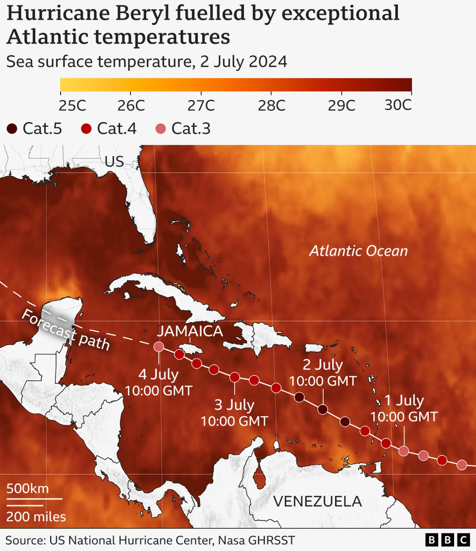
But exceptionally high sea surface temperatures are seen as a key reason why Hurricane Beryl has been so powerful.
Usually, such strong storms only develop later in the season, after the seas have heated up through the summer.
Hurricanes generally need the sea surface to be at least 27C in order to have a chance of developing. As the map below shows, waters along Hurricane Beryl’s path have been much warmer than this.
All else being equal, warmer seas mean more powerful hurricanes, because the storms can pick up more energy, enabling higher wind speeds.
“We know that as we warm the planet, we’re warming our sea surface temperatures as well,” explains Andra Garner, an assistant professor at Rowan University in the US.
“And we know that those warm ocean waters are a critical fuel source for hurricanes.”
In the main Atlantic hurricane development region, the ocean heat content – the energy stored throughout the water column – is at levels not usually seen until September.
That is when the Atlantic hurricane season is usually at its most active, as the sea surface is typically at its warmest at the end of summer.
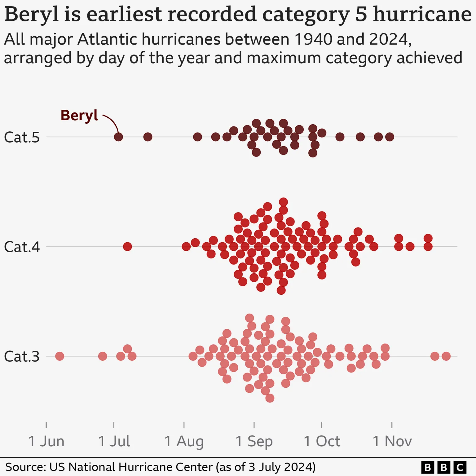
This is illustrated by the chart below, where a dot represents a major hurricane between 1940 and 2024. As you can see, most major hurricanes happen in late August and September, and earlier ones are very rare.
While a category five hurricane is unheard of this early in the season, its strength fits into the broader picture of how these storms are changing in a warming world.
The number of hurricanes has not been increasing, but a higher proportion of them are expected to reach the highest categories globally as temperatures rise.
“Although it is uncertain to what extent climate change contributed to the early formation of Hurricane Beryl, our climate models suggest that the mean intensity of hurricanes will increase in the future due to enhanced global warming,” explains Hiroyuki Murakami, research scientist at NOAA’s Geophysical Fluid Dynamics Laboratory. […]
Rapid intensification
Meteorologists and climate scientists have also remarked about how quickly Hurricane Beryl strengthened.
It took just 42 hours to go from a tropical depression – with maximum sustained wind speeds of 38mph or less – to a major hurricane (meaning above 111mph).
“What makes Beryl particularly notable is that it […] intensified the fastest from a tropical depression to a hurricane [of any Atlantic hurricane in June or early July],” explains Shuyi Chen, professor of atmospheric science at the University of Washington.
Hurricane Beryl is an example of “rapid intensification” – where maximum wind speeds increase very quickly. It can be especially dangerous, because communities have less time to prepare.
The frequency and magnitude of these rapid intensification events in the Atlantic appears to have increased in recent decades.
“Unprecedented as Beryl is, it actually very much aligns with the kinds of extremes we expect in a warmer climate,” Dr Garner says.
“As we’re warming the planet, we’re essentially ‘stacking the deck’ of extreme events against ourselves, making events like Hurricane Beryl not only possible, but more likely.”
“It’s up to us to reduce our emissions to change that story.” [more]
How record-breaking Hurricane Beryl is a sign of a warming world