Amazon deforestation in April 2022 increased by 54 percent, making it the worst April in the last 15 years
11 May 2022 (Imazon) – The Amazon is getting closer and closer to suffering from a new annual record for deforestation. However, there is still time to reduce forest loss before the so-called “deforestation calendar” closes at the end of July. And the time to act must be now, because in May begins the dry season in the region, when most of the devastation of the year is usually recorded.
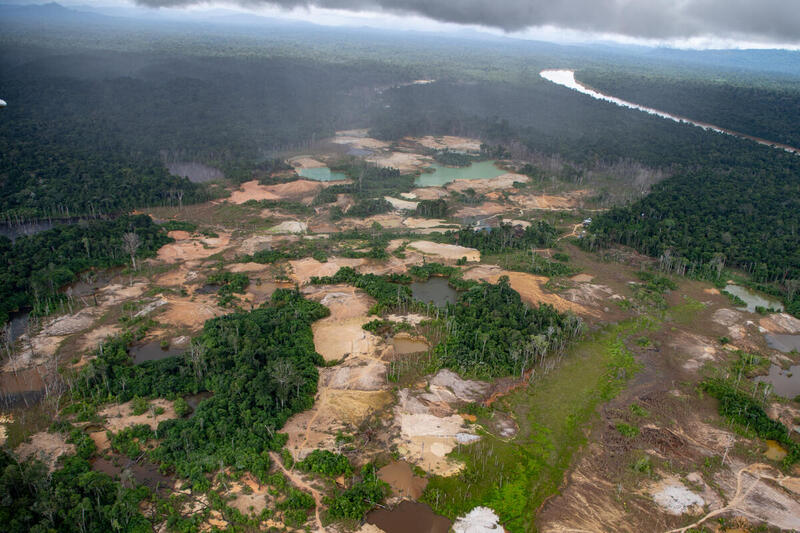
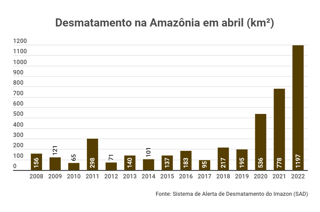
Only in April, the last month of the “rainy season”, the so-called “Amazonian winter”, an area of forest the size of the city of Rio de Janeiro was put down in the biome. Data from the Deforestation Alert System (SAD) of the Institute of Man and the Environment of the Amazon (Imazon) detected a loss of 1,197 km², 54 percent more than that recorded in the same month of 2021. As a result, the region had the worst April in the last 15 years since the institute began satellite monitoring in 2008.
These data serve as a sign of urgency for actions to be implemented before the estimated 15,000 km² felled between August 2021 and June 2022 becomes a reality. The forecast is the artificial intelligence platform PrevisIA, which has been proving to be an assertive tool in indicating the areas at greatest risk of deforestation in the Amazon.
That’s because, of the entire area of forest felled in the last nine months, 75 percent were within a radius of up to 4 km from the point estimated by the platform. To assess this assertion, researchers from Imazon, the institution responsible for generating PrevisIA data, crossed the areas that the tool indicated were at risk of devastation between August 2021 and July 2022 with deforestation already detected by SAD between August and April.
“This analysis showed us that the platform can help a lot to prevent the felling of the forest and still generate savings of resources and time for public agencies that have the mission to protect the Amazon, because it assertively indicates where to direct prevention efforts. We hope that PrevisIA will make a mistake, because we want its data to help guide effective actions to prevent deforestation. Unfortunately, but unfortunately, we are seeing the prediction come true,” said Carlos Souza Jr., a researcher at Imazon.
And this, remembering that SAD data and other monthly monitoring generate a conservative estimate of deforestation, because they need to use the images of the month analyzed, which can suffer more from cloud interference. PrevisIA estimates the number of the Prodes system of the National Institute of Space Research (Inpe), which makes an annual reading of the forest felling, being able to choose images with less cloud interference than the monthly systems.
Yanomami territory tops risk rankings
Indigenous land where residents have called for actions against the invasions of prospectors and denounced a series of crimes of which are being victims, Yanomami, located in the states of Roraima and Amazonas, occupies the top of previsia’s risk ranking. And in April, it was the second most deforested indigenous territory in the Amazon according to the SAD, with an area of forest felled equivalent to 100 soccer fields.
In relation to the states, Mato Grosso was the most deforested for the fourth consecutive month, with 372 km² knocked down, 31% of all destruction recorded in the region. In second place was the Amazon, with 348 km² deforested (29%), and third pará, with 243 km² (20%).
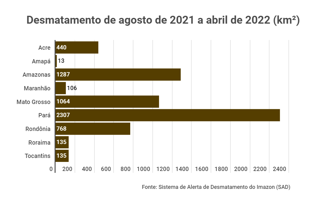
However, if we take into account the period from August 2021 to April 2022, the first nine months of the so-called “deforestation calendar” of the Amazon, which runs from August from one year to July of the following year, it is Pará that leads with 38 percent of accumulated deforestation. In the state, there is a serious problem regarding the increased devastation within protected areas.
“In April, for example, 40 percent of all the devastation recorded in Pará occurred only within five conservation units: 95 km². Therefore, it is necessary to intensify the protection actions in these territories, which were created precisely for the forest to be conserved, which is not happening”, warns researcher Larissa Amorim.
About PrevisIA
With a methodology developed from research in the area of risk prediction of Imazon, published in international scientific journals, PrevisIA analyzes several variables to point out the areas at greatest risk of deforestation in the Amazon. Among them are topography, territory category, deforestation history, urban infrastructure, distance to roads and socioeconomic data. In addition, the tool relies on an artificial intelligence algorithm created by Imazon to detect and monitor open roads in the Amazon, which have a great weight in analyzing the risk of devastation.
Launched last year from a partnership between the institute, Microsoft and Fundo Vale, the platform estimated deforestation of 15,000 km² for the period from August 2021 to July 2022. This area was divided into a map with five risk ratings: very low, low, medium, high and very high. [Translation by Bing]
Deforestation in the Amazon grows 54 percent and reaches worst April in the last 15 years