Tropical Storm Dorian heads for Puerto Rico, Bahamas and Florida could be next

By Bob Henson
27 August 2019
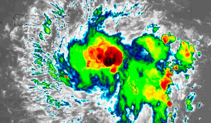
(Weather Underground) – Nudged on all sides by a grab bag of influences, Tropical Storm Dorian has held its own, working its way into the eastern Caribbean after passing near Barbados and over St. Lucia. Dorian is likely to move across Puerto Rico as a tropical storm on Wednesday afternoon and evening, and longer-range models point toward a track that could angle across The Bahamas and westward into Florida. Dorian’s strength by later this week remains a big question mark, but a hurricane on Florida’s East Coast over Labor Day weekend is a distinct possibility.
As of 8 pm EDT Tuesday, Dorian was centered about 300 miles southeast of Ponce, Puerto Rico, moving west-northwest at 13 mph. Dorian’s small core was disrupted when it passed directly over the high terrain of St. Lucia, and a new center formed about 60 miles to the north on Tuesday afternoon. As of 7 pm EDT Tuesday, the heaviest rains from Dorian in the Weather Underground PWS network were 4.1” on Martinique. The heavy rains led to widespread flash flooding on the island, as reported by weather.com. […]
Dorian’s impacts on Puerto Rico
The relocated center of Dorian means that the storm’s projected track has shifted slightly north and east, enough to raise the odds that the storm will make landfall in Puerto Rico. The NHC forecast has Dorian passing across the central and western parts of the island late Wednesday. Widespread rains of 4-6” with pockets of 8” can be expected, especially on south-facing slopes. Mudslides will be a threat, especially where soils have been destabilized by the loss of trees in Hurricane Maria. Sustained tropical-storm force winds will most likely be limited to a small area near and just east of Dorian’s center, but these could be enough to bring down trees and power lines. [more]
Tenacious Dorian Heads for Puerto Rico; Bahamas and Florida Could Be Next


