Amazon deforestation in June 2019 is 57 percent higher than in the same month of 2018
3 July 2019 (Folha de São Paulo) – Deforestation in the Amazon in June was about 57% higher than in the same month last year, according to DETER, the deforestation alert system of the National Institute for Space Research (INPE). [Translation by Google.]
The data from last month, for the time being, only go until the 28th – which may still cause changes in the growth rate of deforestation.
In the month of June, about 769 km² were deforested, according to DETER. By 2018, the value was approximately 488 km².
The rates pointed out by DETER, however, are different from the level of consolidated deforestation published annually through Prodes , also of INPE. […]
According to Imazon’s analysis of the DETER data, from August of last year until June of this year, there was an increase in deforestation of around 8% when compared to the same period last year.
The deforestation in the Amazon has shown a growth trend since 2012, year in which it reached its lowest historical value.
Last year (considering the period between 2017 and 2018), the destruction of the Amazon reached the highest level of the last decade, with 7,900 km² of forest felled. [more]
Desmatamento da Amazônia em junho é 57% maior do que no mesmo mês de 2018
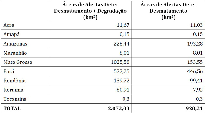
São José dos Campos-SP, 4 July 2019 (INPE) – The areas of alert for deforestation and degradation in the Amazon rainforest totaled 2,072.03 km² in June 2019, according to data recorded by DETER, the Real Time Deforestation Detection System (DETER) of the National Institute for Space Research (INPE). Based on images from Earth observation satellites, the DETER system is designed to guide field inspection by the competent bodies. Considering only the deforestation type alerts, where forest cover has already been removed, the areas mapped in June amount to 920.21 km². The distribution of alert areas by status is shown below. [Translation by Google.]
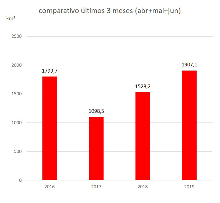
The areas of clearcut deforestation in the last three months (April, May and June / 2019) accumulate a total of 1,907.1 km 2 . In 2018, 1,528.2 km 2 were registered in the same period, that is, an increase of 24.8%. When analyzing the calendar year of deforestation – August / 2018 to June / 2019 – DETER points to 4,574.9 km 2 , 15.1% higher than the August / 2017 to June / 2018, which was 3,975.5 km 2 . These comparisons are presented in the following graphs: [more]